 |
|
Location
& QuickFacts
|
FAA
Information Effective: |
2006-09-28 |
|
Airport
Identifier: |
CT70 |
|
Longitude/Latitude: |
071-52-46.2580W/42-00-50.3490N
-71.879516/42.013986 (Estimated) |
|
Elevation: |
400 ft / 121.92 m (Estimated) |
|
Land: |
0 acres |
|
From
nearest city: |
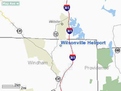
1 nautical miles W of Wilsonville, CT |
|
Location: |
Windham County, CT |
|
Magnetic Variation: |
15W (1985) |
Owner
& Manager
|
Ownership: |
Privately owned |
|
Owner: |
Tilcon Connecticut Inc. |
|
Address: |
P.o. Box 1357
New Britain, CT 06050 |
|
Phone
number: |
203-223-3651 |
|
Manager: |
Albert F Paolini |
|
Address: |
P.o. Box 1357
New Britain, CT 06050 |
|
Phone number: |
203-223-3651 |
Airport
Operations and Facilities
|
Airport
Use: |
Private |
|
Wind
indicator: |
Yes |
|
Segmented
Circle: |
No |
|
Control
Tower: |
No |
|
Attendance
Schedule: |
10/MON-FRI/0800-1700 |
|
Landing
fee charge: |
No |
|
Sectional
chart: |
New York |
|
Region: |
ANE - New England |
|
Boundary
ARTCC: |
ZBW - Boston |
|
Tie-in
FSS: |
BDR - Bridgeport |
|
FSS
on Airport: |
No |
|
FSS
Phone: |
866-293-5149 |
|
FSS
Toll Free: |
1-800-WX-BRIEF |
|
Runway Information
Helipad H1
|
Dimension: |
130 x 100 ft / 39.6 x 30.5 m
TRIANGULAR AREA 130 X 100 X 100'. |
|
Surface: |
ASPH-GRVL, |
| |
Runway H1 |
Runway |
|
Traffic
Pattern: |
Left |
Left |
|
Radio Navigation
Aids
|
ID |
Type |
Name |
Ch |
Freq |
Var |
Dist |
|
ORW |
FAN MARKER |
Canton |
|
|
15W |
33.6 nm |
|
SFZ |
NDB |
Central |
|
241.00 |
15W |
18.4 nm |
|
IHM |
NDB |
Mansfield |
|
220.00 |
16W |
30.5 nm |
|
FIT |
NDB |
Fitchburg |
|
365.00 |
15W |
32.7 nm |
|
ORE |
NDB |
Orange |
|
205.00 |
15W |
37.9 nm |
|
TAN |
NDB |
Taunton |
|
227.00 |
16W |
39.4 nm |
|
HF |
NDB |
Lomis |
|
244.00 |
15W |
40.4 nm |
|
SKR |
NDB |
Shaker Hill |
|
251.00 |
16W |
41.0 nm |
|
LQ |
NDB |
Lyndy |
|
382.00 |
16W |
48.5 nm |
|
FFF |
NDB |
Plymouth |
|
257.00 |
16W |
49.2 nm |
|
NZW |
TACAN |
South Weymouth |
061X |
|
15W |
42.8 nm |
|
PUT |
VOR/DME |
Putnam |
121X |
117.40 |
14W |
3.9 nm |
|
ORW |
VOR/DME |
Norwich |
037X |
110.00 |
14W |
28.0 nm |
|
HFD |
VOR/DME |
Hartford |
096X |
114.90 |
13W |
37.4 nm |
|
GON |
VOR/DME |
Groton |
45Y |
110.85 |
14W |
41.8 nm |
|
PVD |
VORTAC |
Providence |
103X |
115.60 |
14W |
26.6 nm |
|
CEF |
VORTAC |
Westover |
87X |
114.00 |
14W |
30.9 nm |
|
GDM |
VORTAC |
Gardner |
043X |
110.60 |
14W |
32.9 nm |
|
BDL |
VORTAC |
Bradley |
027X |
109.00 |
14W |
36.4 nm |
|
BAF |
VORTAC |
Barnes |
077X |
113.00 |
14W |
38.4 nm |
|
BOS |
VORTAC |
Boston |
074X |
112.70 |
16W |
44.7 nm |
|
ORH |
VOT |
Worcester |
|
108.20 |
|
15.2 nm |
|
PVD |
VOT |
Providence |
|
108.20 |
|
26.7 nm |
|
BDL |
VOT |
Bradley Intl |
|
111.40 |
|
36.2 nm |
|
BED |
VOT |
Laurence G Hanscom Fld |
|
110.00 |
|
37.9 nm |
|
HFD |
VOT |
Hartford |
|
108.20 |
|
38.4 nm |
|
GON |
VOT |
Groton |
|
110.25 |
|
42.1 nm |
|
BOS |
VOT |
Boston Logan Intl |
|
111.00 |
|
44.0 nm |
Remarks
Wilsonville Heliport
Address:
Windham County, CT
Tel:
203-223-3651
Images
and information placed above are from
http://www.airport-data.com/airport/CT70/
We
thank them for the data!
| General
Info |
| Country |
United
States |
| State |
CONNECTICUT
|
| FAA ID |
CT70
|
| Latitude |
42-00-50.349N
|
| Longitude |
071-52-46.258W
|
| Elevation |
400 feet
|
| Near City |
WILSONVILLE
|
We don't guarantee the information is fresh and accurate. The data may
be wrong or outdated.
For more up-to-date information please refer to other sources.
|
|


