 |
|
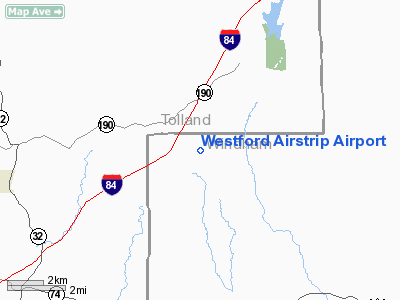
Westford Airstrip Airport |
|
|
Location
& QuickFacts
|
FAA
Information Effective: |
2006-09-28 |
|
Airport
Identifier: |
CT74 |
|
Longitude/Latitude: |
072-10-53.2780W/41-57-02.3480N
-72.181466/41.950652 (Estimated) |
|
Elevation: |
900 ft / 274.32 m (Estimated) |
|
Land: |
0 acres |
|
From
nearest city: |
2 nautical miles N of Ashford/westford, CT |
|
Location: |
Windham County, CT |
|
Magnetic Variation: |
15W (1985) |
Owner
& Manager
|
Ownership: |
Privately owned |
|
Owner: |
Charles J. Woytik |
|
Address: |
77 Waterfall Rd.
Stafford Springs, CT.06076 |
|
Phone
number: |
203-684-4559
OR 203-684-3010 |
|
Manager: |
Charles J. Woytik |
|
Address: |
77 Waterfall Rd.
Stafford Springs, CT.06076 |
|
Phone number: |
203-684-4559
OR 203-684-3010 |
Airport
Operations and Facilities
|
Airport
Use: |
Private |
|
Wind
indicator: |
Yes |
|
Segmented
Circle: |
No |
|
Control
Tower: |
No |
|
Attendance
Schedule: |
UNATNDD |
|
Landing
fee charge: |
No |
|
Sectional
chart: |
New York |
|
Region: |
ANE - New England |
|
Boundary
ARTCC: |
ZBW - Boston |
|
Tie-in
FSS: |
BDR - Bridgeport |
|
FSS
on Airport: |
No |
|
FSS
Phone: |
866-293-5149 |
|
FSS
Toll Free: |
1-800-WX-BRIEF |
|
Runway Information
Runway N/S
|
Dimension: |
1300 x 200 ft / 396.2 x 61.0 m |
|
Surface: |
TURF, |
| |
Runway N |
Runway S |
|
Traffic
Pattern: |
Left |
Left |
|
Radio Navigation
Aids
|
ID |
Type |
Name |
Ch |
Freq |
Var |
Dist |
|
ORW |
FAN MARKER |
Canton |
|
|
15W |
47.6 nm |
|
HF |
NDB |
Lomis |
|
244.00 |
15W |
27.5 nm |
|
SFZ |
NDB |
Central |
|
241.00 |
15W |
31.0 nm |
|
ORE |
NDB |
Orange |
|
205.00 |
15W |
37.4 nm |
|
MMK |
NDB |
Meriden |
|
238.00 |
14W |
39.3 nm |
|
FIT |
NDB |
Fitchburg |
|
365.00 |
15W |
40.7 nm |
|
IHM |
NDB |
Mansfield |
|
220.00 |
16W |
44.1 nm |
|
PUT |
VOR/DME |
Putnam |
121X |
117.40 |
14W |
15.1 nm |
|
HFD |
VOR/DME |
Hartford |
096X |
114.90 |
13W |
24.8 nm |
|
ORW |
VOR/DME |
Norwich |
037X |
110.00 |
14W |
25.1 nm |
|
GON |
VOR/DME |
Groton |
45Y |
110.85 |
14W |
37.7 nm |
|
CTR |
VOR/DME |
Chester |
098X |
115.10 |
13W |
39.9 nm |
|
MAD |
VOR/DME |
Madison |
041X |
110.40 |
13W |
44.6 nm |
|
CEF |
VORTAC |
Westover |
87X |
114.00 |
14W |
21.4 nm |
|
BDL |
VORTAC |
Bradley |
027X |
109.00 |
14W |
22.7 nm |
|
BAF |
VORTAC |
Barnes |
077X |
113.00 |
14W |
27.0 nm |
|
GDM |
VORTAC |
Gardner |
043X |
110.60 |
14W |
36.2 nm |
|
PVD |
VORTAC |
Providence |
103X |
115.60 |
14W |
36.3 nm |
|
BDL |
VOT |
Bradley Intl |
|
111.40 |
|
22.4 nm |
|
ORH |
VOT |
Worcester |
|
108.20 |
|
23.6 nm |
|
HFD |
VOT |
Hartford |
|
108.20 |
|
24.7 nm |
|
PVD |
VOT |
Providence |
|
108.20 |
|
36.5 nm |
|
GON |
VOT |
Groton |
|
110.25 |
|
38.1 nm |
Remarks
Based Aircraft
|
Aircraft
based on field: |
2 |
|
Single
Engine Airplanes: |
1 |
|
Ultralights: |
1 |
Westford Airstrip Airport
Address:
Windham County, CT
Tel:
203-684-4559,
203-684-3010
Images
and information placed above are from
http://www.airport-data.com/airport/CT74/
We
thank them for the data!
| General
Info |
| Country |
United
States |
| State |
CONNECTICUT
|
| FAA ID |
CT74
|
| Latitude |
41-57-02.348N
|
| Longitude |
072-10-53.278W
|
| Elevation |
900 feet
|
| Near City |
ASHFORD/WESTFORD
|
We don't guarantee the information is fresh and accurate. The data may
be wrong or outdated.
For more up-to-date information please refer to other sources.
|
|


