 |
|
| Robertson Field |
| IATA: none – ICAO: none – FAA LID: 4B8 |
| Summary |
| Airport type |
Public |
| Owner |
Town of Plainville |
| Operator |
Interstate Aviation, Inc. |
| Location |
Plainville, Connecticut |
| Elevation AMSL |
200 ft / 61 m |
| Coordinates |
41°41′25″N 072°51′53″W / 41.69028°N 72.86472°W / 41.69028; -72.86472 |
| Runways |
| Direction |
Length |
Surface |
| ft |
m |
| 2/20 |
3,612 |
1,101 |
Asphalt |
| Helipads |
| Number |
Length |
Surface |
| ft |
m |
| H1 |
30 |
9 |
Asphalt |
| Statistics (2006) |
| Aircraft operations |
59,200 |
| Based aircraft |
110 |
| Source: Federal Aviation Administration |
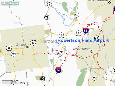
Robertson Field (FAA LID: 4B8), also known as Robertson Airport, is a public use airport located two miles (3 km) north of the central business district of Plainville, a town in Hartford County, Connecticut, United States. It is owned by the Town of Plainville.
The Town of Plainville purchased the airport from Tomasso Brothers, Inc. for a price of $7.7 million USD on December 30, 2009. Previously, the town had explored a purchase of the airport beginning in 1995. It was appraised by Tomasso at $6.5 million, double its tax assessment by the town. In July 2007, the town received a $116,850 federal grant to further study buying the airport.
Robertson Airport is primarily used for charter flights and flight training. History
Opened in 1911, Robertson Field is the oldest airport in Connecticut.
John H. Trumbull, a Plainville native and Connecticut's Governor from 1925 to 1931, is known to have used the airfield. He was dubbed "The Flying Governor".
In 1990 the Tomasso family completed renovation and expansion of the 3,600-foot (1,100 m) runway.
Facilities and aircraft
Robertson Field covers an area of 39 acres (16 ha) which contains one runway and one helipad:
- Runway 2/20: 3,612 x 75 ft. (1,101 x 23 m), Surface: Asphalt
- Helipad H1: 30 x 30 ft. (9 x 9 m), Surface: Asphalt
For the 12-month period ending July 31, 2006, the airport had 59,200 aircraft operations, an average of 162 per day: 97% general aviation, 3% air taxi and <1% military. There are 110 aircraft based at this airport: 90% single engine, 8% multi-engine, and 2% Jet.
The above content comes from Wikipedia and is published under free licenses – click here to read more.
Location
& QuickFacts
|
FAA
Information Effective: |
2006-09-28 |
|
Airport
Identifier: |
4B8 |
|
Longitude/Latitude: |
072-51-53.3610W/41-41-25.3560N
-72.864822/41.690377 (Estimated) |
|
Elevation: |
200 ft / 60.96 m (Surveyed) |
|
Land: |
39 acres |
|
From
nearest city: |
2 nautical miles N of Plainville, CT |
|
Location: |
Hartford County, CT |
|
Magnetic Variation: |
14W (2000) |
Owner
& Manager
|
Ownership: |
Privately owned |
|
Owner: |
Tomasso Brothers, Inc |
|
Address: |
Po Box 3040
New Britain, CT 06050 |
|
Phone number: |
203-224-9977 |
|
Manager: |
Wm O'leary |
|
Address: |
62 Johnson Avenue
Plainville, CT 06062 |
|
Phone number: |
203-747-5519 |
Airport
Operations and Facilities
|
Airport
Use: |
Open to public |
|
Wind
indicator: |
Yes |
|
Segmented
Circle: |
No |
|
Control
Tower: |
No |
|
Attendance
Schedule: |
OCT-APR/ALL/0630-2000,MAY-SEP/ALL/0730-2000 |
|
Lighting
Schedule: |
DUSK-DAWN
ACTVT MIRL RY 02/20 - CTAF. REIL RYS 02 & 20 OPR WHEN
RY LGTS ON HIGH INTST. |
|
Beacon
Color: |
Clear-Green (lighted land airport) |
|
Landing
fee charge: |
No
LANDING FEE FOR COMMERCIAL AND CORPORATE ACFT ONLY. |
|
Sectional
chart: |
New York |
|
Region: |
ANE - New England |
|
Traffic
Pattern Alt: |
800 ft |
|
Boundary
ARTCC: |
ZBW - Boston |
|
Tie-in
FSS: |
BDR - Bridgeport |
|
FSS
on Airport: |
No |
|
FSS
Phone: |
866-293-5149 |
|
FSS
Toll Free: |
1-800-WX-BRIEF |
|
NOTAMs
Facility: |
BDR (NOTAM-d service avaliable) |
|
Federal Agreements: |
N |
Airport
Communications
|
CTAF: |
122.800 |
|
Unicom: |
122.800 |
Airport
Services
|
Fuel
available: |
100LLA |
|
Airframe
Repair: |
MAJOR |
|
Power
Plant Repair: |
MAJOR |
|
Bottled
Oxygen: |
NONE |
|
Bulk
Oxygen: |
HIGH |
|
Runway Information
Runway 02/20
|
Dimension: |
3612 x 75 ft / 1100.9 x 22.9 m |
|
Surface: |
ASPH, Good Condition |
|
Weight
Limit: |
Single wheel: 25000 lbs. |
|
Edge
Lights: |
Medium |
|
|
Runway 02 |
Runway 20 |
|
Traffic
Pattern: |
Left |
Left |
|
Markings: |
Basic, Good Condition |
Basic, Good Condition |
|
Runway
End Identifier: |
Yes |
Yes |
|
Obstruction: |
, 50:1 slope to clear |
15 ft trees, 501.0 ft from runway, 101 ft right
of centerline, 20:1 slope to clear |
|
Helipad H1
|
Dimension: |
30
x 30 ft / 9.1 x 9.1 m |
|
Surface: |
ASPH, Good Condition |
|
|
Runway H1 |
Runway |
|
Traffic
Pattern: |
Left |
Left |
|
Radio Navigation
Aids
|
ID |
Type |
Name |
Ch |
Freq |
Var |
Dist |
|
GBR |
FAN MARKER |
Sheffield |
|
|
13W |
34.5 nm |
|
PSF |
FAN MARKER |
Abyss |
|
|
13W |
48.6 nm |
|
MMK |
NDB |
Meriden |
|
238.00 |
14W |
10.9 nm |
|
HF |
NDB |
Lomis |
|
244.00 |
15W |
11.2 nm |
|
TBY |
NDB |
Waterbury |
|
257.00 |
14W |
15.8 nm |
|
GBR |
NDB |
Great Barrington |
|
395.00 |
14W |
38.2 nm |
|
OP |
NDB |
Old Field Point Light |
|
316.00 |
13W |
44.4 nm |
|
DXT |
NDB |
Dalton |
|
370.00 |
15W |
48.9 nm |
|
PO |
NDB |
Meier |
|
403.00 |
12W |
49.9 nm |
|
HFD |
VOR/DME |
Hartford |
096X |
114.90 |
13W |
14.6 nm |
|
MAD |
VOR/DME |
Madison |
041X |
110.40 |
13W |
23.9 nm |
|
HVN |
VOR/DME |
New Haven |
035X |
109.80 |
13W |
25.7 nm |
|
PWL |
VOR/DME |
Pawling |
090X |
114.30 |
12W |
33.3 nm |
|
BDR |
VOR/DME |
Bridgeport |
25X |
108.80 |
12W |
33.9 nm |
|
CTR |
VOR/DME |
Chester |
098X |
115.10 |
13W |
36.3 nm |
|
ORW |
VOR/DME |
Norwich |
037X |
110.00 |
14W |
39.7 nm |
|
CMK |
VOR/DME |
Carmel |
113X |
116.60 |
12W |
40.6 nm |
|
GON |
VOR/DME |
Groton |
45Y |
110.85 |
14W |
42.5 nm |
|
IGN |
VOR/DME |
Kingston |
123X |
117.60 |
12W |
43.0 nm |
|
CCC |
VOR/DME |
Calverton |
119X |
117.20 |
13W |
45.8 nm |
|
PUT |
VOR/DME |
Putnam |
121X |
117.40 |
14W |
48.4 nm |
|
BDL |
VORTAC |
Bradley |
027X |
109.00 |
14W |
17.0 nm |
|
BAF |
VORTAC |
Barnes |
077X |
113.00 |
14W |
29.1 nm |
|
CEF |
VORTAC |
Westover |
87X |
114.00 |
14W |
34.0 nm |
|
HFD |
VOT |
Hartford |
|
108.20 |
|
9.9 nm |
|
BDL |
VOT |
Bradley Intl |
|
111.40 |
|
17.0 nm |
|
BDR |
VOT |
Bridgeport |
|
109.25 |
|
33.9 nm |
|
GON |
VOT |
Groton |
|
110.25 |
|
42.7 nm |
Remarks
Based Aircraft
|
Aircraft
based on field: |
110 |
|
Single
Engine Airplanes: |
103 |
|
Multi
Engine Airplanes: |
7 |
Operational Statistics
|
Aircraft
Operations: |
163/Day |
|
Air Taxi: |
2.8% |
|
General
Aviation Local: |
79.4% |
|
General
Aviation Itinerant: |
17.7% |
|
Military: |
0.1% |
Robertson Field Airport
Address:
Hartford County, CT
Tel:
203-224-9977, 203-747-5519
Images
and information placed above are from
http://www.airport-data.com/airport/4B8/
We
thank them for the data!
| General
Info |
| Country |
United
States |
| State |
CONNECTICUT
|
| FAA ID |
4B8
|
| Latitude |
41-41-25.356N
|
| Longitude |
072-51-53.361W
|
| Elevation |
200 feet
|
| Near City |
PLAINVILLE
|
We don't guarantee the information is fresh and accurate. The data may
be wrong or outdated.
For more up-to-date information please refer to other sources.
|
|


