|
|
Hartford-brainard Airport |
| Hartford-Brainard Airport |
 |
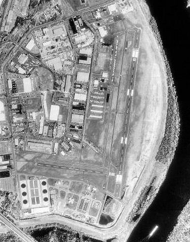
| USGS image as of 23 April 1990 |
| IATA: HFD – ICAO: KHFD – FAA LID: HFD |
| Summary |
| Airport type |
Public |
| Owner |
Connecticut Department of Transportation (ConnDOT) |
| Location |
Hartford, Connecticut |
| Elevation AMSL |
18 ft / 5 m |
| Coordinates |
41°44′12″N 072°38′58″W / 41.73667°N 72.64944°W / 41.73667; -72.64944 |
| Runways |
| Direction |
Length |
Surface |
| ft |
m |
| 2/20 |
4,417 |
1,346 |
Asphalt |
| 11/29 |
2,314 |
705 |
Asphalt |
| NE/SW |
2,309 |
704 |
Turf |
| Helipads |
| Number |
Length |
Surface |
| ft |
m |
| H1 |
70 |
21 |
Asphalt |
| Statistics (2001) |
| Aircraft operations |
120,217 |
| Based aircraft |
144 |
| Source: Federal Aviation Administration |
FAA airport diagram Hartford-Brainard Airport (IATA: HFD, ICAO: KHFD, FAA LID: HFD) is a Class D, towered public airport located three miles (5 km) southeast of downtown Hartford, in Hartford County, Connecticut, United States. It is owned by the Connecticut Department of Transportation (ConnDOT). Facilities and aircraft
Hartford-Brainard Airport covers 201 acres (81 ha) which contains three runways and one helipad:
- Runway 2/20: 4,417 x 150 ft (1,346 x 46 m), Surface: Asphalt
- Runway 11/29: 2,314 x 71 ft (705 x 22 m), Surface: Asphalt
- Runway NE/SW: 2,309 x 150 ft (704 x 46 m), Surface: Turf (Closed during winter months from November 2 to April 30 except for Ski-Equipped aircraft or helicopter training.)
- Helipad H1: 70 x 77 ft (21 x 23 m), Surface: Asphalt
For the 12-month period ending June 12, 2001, the airport had 120,217 aircraft operations, an average of 329 per day: 99% general aviation, 1% air taxi and <1% military. There are 144 aircraft based at this airport: 87% single engine, 10% multi-engine, 1% jet aircraft, 1% helicopters and 1% gliders.
The above content comes from Wikipedia and is published under free licenses – click here to read more.
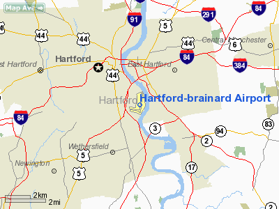
Location
& QuickFacts
|
FAA
Information Effective: |
2006-09-28 |
|
Airport
Identifier: |
HFD |
|
Longitude/Latitude: |
072-38-58.0000W/41-44-12.2000N
-72.649444/41.736722 (Estimated) |
|
Elevation: |
18 ft / 5.49 m (Surveyed) |
|
Land: |
201 acres |
|
From
nearest city: |
3 nautical miles SE of Hartford, CT |
|
Location: |
Hartford County, CT |
|
Magnetic Variation: |
15W (1995) |
Owner
& Manager
|
Ownership: |
Publicly owned |
|
Owner: |
State Of Connecticut |
|
Address: |
Po Box 317546
Newington, CT 06131 |
|
Phone number: |
860-594-2529 |
|
Manager: |
Kenneth Milano |
|
Address: |
251 Maxim Road
Hartford, CT 06114 |
|
Phone number: |
860-566-7037 |
Airport
Operations and Facilities
|
Airport
Use: |
Open to public |
|
Wind
indicator: |
Yes |
|
Segmented
Circle: |
Yes |
|
Control
Tower: |
Yes |
|
Attendance
Schedule: |
ALL/MON-FRI/ALL,ALL/SAT-SUN/0600-2300 |
|
Lighting
Schedule: |
DUSK-DAWN
WHEN ATCT CLSD ACTVT HIRL RY 02/20 & REIL RYS 02 &
20 - CTAF. |
|
Beacon
Color: |
Clear-Green (lighted land airport) |
|
Landing
fee charge: |
No
LANDING FEE FOR BUSINESS/CORPORATE & REVENUE PRODUCING
ACFT. |
|
Sectional
chart: |
New York |
|
Region: |
ANE - New England |
|
Traffic
Pattern Alt: |
1000 ft |
|
Boundary
ARTCC: |
ZBW - Boston |
|
Tie-in
FSS: |
BDR - Bridgeport |
|
FSS
on Airport: |
No |
|
FSS
Phone: |
866-293-5149 |
|
FSS
Toll Free: |
1-800-WX-BRIEF |
|
NOTAMs
Facility: |
HFD (NOTAM-d service avaliable) |
|
Federal Agreements: |
NGY3 |
Airport
Communications
|
CTAF: |
119.600 |
|
Unicom: |
122.950 |
Airport
Services
|
Fuel
available: |
100LLA |
|
Airframe
Repair: |
MAJOR |
|
Power
Plant Repair: |
MAJOR |
|
Bottled
Oxygen: |
NONE |
|
Bulk
Oxygen: |
NONE |
|
Runway Information
Runway 02/20
|
Dimension: |
4417 x 150 ft / 1346.3 x 45.7 m |
|
Surface: |
ASPH, Good Condition |
|
Surface
Treatment: |
Saw-cut or plastic Grooved
GROOVING 130 FT WIDE. |
|
Weight
Limit: |
Single wheel: 30000 lbs.
Dual wheel: 43000 lbs.
Dual
tandem wheel: 70000 lbs. |
|
Edge
Lights: |
High |
|
|
Runway 02 |
Runway 20 |
|
Longitude: |
072-38-59.3182W |
072-38-50.2639W |
|
Latitude: |
41-43-53.8973N |
41-44-37.0017N |
|
Elevation: |
11.00
ft |
18.00
ft |
|
Alignment: |
9 |
127 |
|
ILS
Type: |
LDA |
|
|
Traffic
Pattern: |
Left |
Left |
|
Markings: |
Non-precision instrument, Good Condition |
Non-precision instrument, Good Condition |
|
Displaced
threshold: |
411.00 ft |
560.00 ft |
|
VASI: |
4-box on left side |
4-box on right side |
|
Visual
Glide Angle: |
4.00� |
4.00� |
|
Runway
End Identifier: |
Yes |
Yes |
|
Obstruction: |
55 ft trees, 1075.0 ft from runway, 16:1 slope
to clear
APCH RATIO 20:1 TO DSPLCD THLD. |
38 ft trees, 350.0 ft from runway, 172 ft left
of centerline, 4:1 slope to clear
APCH RATIO 8:1 TO DSPLCD THLD.
+27' BERM 200' FM RY END. |
|
Runway 11/29
|
Dimension: |
2314 x 71 ft / 705.3 x 21.6 m |
|
Surface: |
ASPH, Good Condition |
|
Weight
Limit: |
Single wheel: 10000 lbs. |
|
Edge
Lights: |
High |
|
|
Runway 11 |
Runway 29 |
|
Longitude: |
072-39-27.2883W |
072-38-57.1363W |
|
Latitude: |
41-44-03.0855N |
41-43-59.5425N |
|
Elevation: |
14.00
ft |
12.00
ft |
|
Alignment: |
99 |
127 |
|
Traffic
Pattern: |
Left |
Left |
|
Markings: |
Basic, Good Condition |
Basic, Good Condition |
|
Displaced
threshold: |
0.00
ft |
265.00 ft |
|
Runway
End Identifier: |
No |
No |
|
Obstruction: |
75 ft trees, 1400.0 ft from runway, 35 ft right
of centerline, 16:1 slope to clear |
63 ft trees, 700.0 ft from runway, 8:1 slope
to clear
APCH RATIO 20:1 TO DSPLCD THLD. |
|
Helipad H1
|
Dimension: |
70 x 77 ft / 21.3 x 23.5 m |
|
Surface: |
ASPH, Good Condition |
|
Edge
Lights: |
Medium |
|
|
Runway H1 |
Runway |
|
Traffic
Pattern: |
Left |
Left |
|
Runway NE/SW
|
Dimension: |
2309 x 150 ft / 703.8 x 45.7 m |
|
Surface: |
TURF, |
|
|
Runway NE |
Runway SW |
|
Traffic
Pattern: |
Left |
Left |
|
Obstruction: |
165 ft trees, 3200.0 ft from runway, 19:1 slope
to clear |
133 ft trees, 1000.0 ft from runway, 7:1 slope
to clear |
|
Radio Navigation
Aids
|
ID |
Type |
Name |
Ch |
Freq |
Var |
Dist |
|
GBR |
FAN MARKER |
Sheffield |
|
|
13W |
39.7 nm |
|
HF |
NDB |
Lomis |
|
244.00 |
15W |
6.2 nm |
|
MMK |
NDB |
Meriden |
|
238.00 |
14W |
15.8 nm |
|
TBY |
NDB |
Waterbury |
|
257.00 |
14W |
25.5 nm |
|
GBR |
NDB |
Great Barrington |
|
395.00 |
14W |
43.1 nm |
|
DXT |
NDB |
Dalton |
|
370.00 |
15W |
49.9 nm |
|
HFD |
VOR/DME |
Hartford |
096X |
114.90 |
13W |
7.3 nm |
|
MAD |
VOR/DME |
Madison |
041X |
110.40 |
13W |
25.5 nm |
|
HVN |
VOR/DME |
New Haven |
035X |
109.80 |
13W |
30.4 nm |
|
ORW |
VOR/DME |
Norwich |
037X |
110.00 |
14W |
31.1 nm |
|
CTR |
VOR/DME |
Chester |
098X |
115.10 |
13W |
35.9 nm |
|
GON |
VOR/DME |
Groton |
45Y |
110.85 |
14W |
36.3 nm |
|
PUT |
VOR/DME |
Putnam |
121X |
117.40 |
14W |
38.4 nm |
|
BDR |
VOR/DME |
Bridgeport |
25X |
108.80 |
12W |
40.7 nm |
|
PWL |
VOR/DME |
Pawling |
090X |
114.30 |
12W |
42.7 nm |
|
CCC |
VOR/DME |
Calverton |
119X |
117.20 |
13W |
49.0 nm |
|
BDL |
VORTAC |
Bradley |
027X |
109.00 |
14W |
12.4 nm |
|
BAF |
VORTAC |
Barnes |
077X |
113.00 |
14W |
25.7 nm |
|
CEF |
VORTAC |
Westover |
87X |
114.00 |
14W |
28.2 nm |
|
HFD |
VOT |
Hartford |
|
108.20 |
|
0.1 nm |
|
BDL |
VOT |
Bradley Intl |
|
111.40 |
|
12.2 nm |
|
GON |
VOT |
Groton |
|
110.25 |
|
36.6 nm |
|
BDR |
VOT |
Bridgeport |
|
109.25 |
|
40.7 nm |
|
ORH |
VOT |
Worcester |
|
108.20 |
|
47.2 nm |
Remarks
- BIRDS
& DEER ON & INVOF ARPT.
- ARPT
LCTD IN NOISE SENSITIVE AREA & POPULATED AREAS TO SOUTH & WEST
SHOULD BE AVOIDED; SEE BRAINARD TWR LTRS TO AIRMEN.
- TGL
& PRACTICE INST APCH PROHIBITED MON THRU SAT 2200-0600 & SUN
2200-0900.
- TURF
NE/SW RY CLSD DURG WINTER MONTHS FROM NOV 2 TO APR 30 EXCP FOR SKI-EQUIPPED
ACFT & HELICOPTER TRAINING.
- TWENTY
FT DROP OFF DEP END RY 20.
- EXISTED
PRIOR TO 1959.
Based Aircraft
|
Aircraft
based on field: |
129 |
|
Single
Engine Airplanes: |
109 |
|
Multi
Engine Airplanes: |
14 |
|
Jet Engine
Airplanes: |
4 |
|
Helicopters: |
1 |
|
Gliders: |
1 |
Operational Statistics
|
Aircraft
Operations: |
330/Day |
|
Air Taxi: |
1.1% |
|
General
Aviation Local: |
42.8% |
|
General
Aviation Itinerant: |
56.0% |
|
Military: |
0.1% |
Hartford-brainard Airport
Address:
Hartford County, CT
Tel:
860-594-2529, 860-566-7037
Images
and information placed above are from
http://www.airport-data.com/airport/HFD/
We
thank them for the data!
| General
Info |
| Country |
United
States |
| State |
CONNECTICUT
|
| FAA ID |
HFD
|
| Latitude |
41-44-10.567N
|
| Longitude |
072-39-00.770W
|
| Elevation |
19 feet
|
| Near City |
HARTFORD
|
We don't guarantee the information is fresh and accurate. The data may
be wrong or outdated.
For more up-to-date information please refer to other sources.
|
|