|
|
Groton - New London Airport |
| Groton-New London Airport |
 |
| 12 April 1991 |
| IATA: GON – ICAO: KGON – FAA LID: GON |
| Summary |
| Airport type |
Public |
| Owner |
Connecticut Department of Transportation (ConnDOT) |
| Location |
Groton, Connecticut |
| Elevation AMSL |
9 ft / 3 m |
| Coordinates |
41°19′48″N 072°02′42″W / 41.33°N 72.045°W / 41.33; -72.045 |
| Website |
GrotonNewLondonAirport.com |
| Runways |
| Direction |
Length |
Surface |
| ft |
m |
| 5/23 |
5,000 |
1,524 |
Asphalt |
| 15/33 |
4,000 |
1,219 |
Asphalt |
| Statistics (2006) |
| Aircraft operations |
52,394 |
| Based aircraft |
69 |
| Source: Federal Aviation Administration |
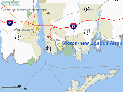
Groton-New London Airport (IATA: GON, ICAO: KGON, FAA LID: GON) is a state-owned public-use airport located three miles (5 km) southeast of the central business district of Groton, a town in New London County, Connecticut, United States. It serves the southeastern Connecticut region, including the shoreline localities of Groton, New London, and Mystic.
Over the years, and usually no more than one at a time, various domestic airlines served the airport, including Pan Am Clipper Connection and Pilgrim Airlines. Scheduled commercial passenger service was limited to small turboprop aircraft such as de Havilland Dash 8 and Beechcraft 1900. Eventually the airport became no longer a profitable destination, and US Airways Express, the last major carrier to serve the airport, terminated its GON-PHL service in 2004. Two charter airlines, however, do continue to shuttle passengers to and from the airport.
The airport has also been used by several presidents speaking at the commencement of the nearby US Coast Guard Academy. The most recent visit was by President Bush on May 23, 2007. Facilities and aircraft
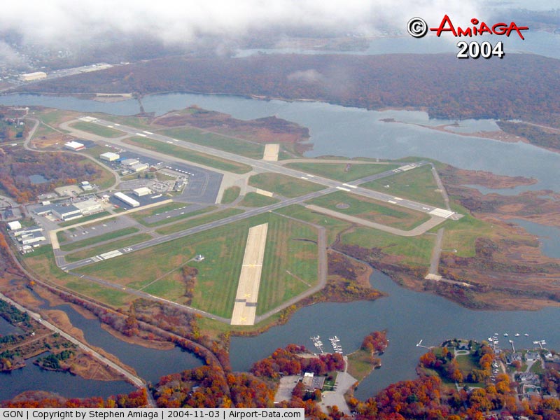
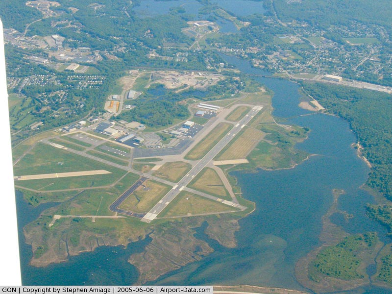
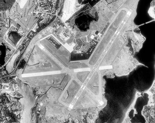
Groton-New London Airport covers an area of 489 acres (198 ha) which contains two asphalt paved runways: 5/23 measuring 5,000 x 150 ft (1,524 x 46 m) and 15/33 measuring 4,000 x 100 ft (1,219 x 30 m).
For the 12-month period ending June 30, 2006, the airport had 52,394 aircraft operations, an average of 143 per day: 87% general aviation, 8% military, 5% air taxi and <1% scheduled commercial. There are 69 aircraft based at this airport: 33% single engine, 25% multi-engine, 14% jet aircraft, 26% helicopters and 1% military.
Charter airlines
- Columbia Air Service
- Lanmar Aviation
History
Groton-New London Airport was established as the first State of Connecticut airport in 1929. Originally called Trumbull Airport after Governor Jonathan Trumbull, the airport was taken over by the United States Army Air Corps in August 1941 as a First Air Force group training base, although the runways were still grass. In 1942, the Army constructed a base and hard-surfaced runways and designated the airport as Groton Army Airfield. Through all of 1943, a total of 10 squadrons of P-47 Thunderbolt fighter groups trained at the field, with the last unit departing for overseas combat in January 1944.
In January 1944, the USAAF turned the airfield to the United States Navy. The commissioning of Groton as a Naval Airfield occurred on February 1, 1944, as an auxiliary of Quonset Point. Initially, Groton hosted various individual squadrons. Later, entire CAGs of three or four squadrons formed up at the base. The CAGs attached here during the war included CAG 83, 10, 92, 152, and 4, with their F6Fs, F4Us, SB2Cs, and TBMs. CASU 28, on board in support of the CAGs, operated one OS2U Kingfisher, one J4F Widgeon, 12 SNJs, and one NH Howard. The station had one airplane assigned, a GH Howard.
In March 1944, station personnel consisted of 87 officers and 678 enlisted men with barracks for 114 officers and 1,091 men. The peak number of aircraft reached 114 in March 1945. Groton had three concrete runways: two of 4,000 feet and one of 5,000 ft. In July 1946, the Navy returned the airport to the State of Connecticut.
In 1980, the name of the airport changed to Groton-New London Airport. Today, the airport is one of two state-owned airports with commercial air carrier service. The funds necessary to operate Groton-New London Airport come from the Connecticut State Transportation Fund. Likewise, revenue derived from the airport is returned to the Transportation Fund.
The airport is integrated into the statewide transportation plan, as well as the National Airport System Plan. There were 80,319 aircraft operations during 1999 at Groton-New London Airport which included military, general aviation and commercial flights. The airport has recently undergone $2,000,000 in renovations. The passenger terminal has been updated with new counter and seating areas and improved lighting.
Groton-New London Airport serves the growing number of business commuters and leisure travelers in the Southeastern Connecticut region in the new millennium. We are proud of our cooperative relationship with Mystic & More, this region's convention and visitor's bureau. The visitor's bureau has made a significant investment in the airport with the addition of their information center in the terminal. Community partnership is a priority for Groton-New London airport.
The above content comes from Wikipedia and is published under free licenses – click here to read more.
|
 |
(Click on the photo to enlarge) |
|
 |
(Click on the photo to enlarge) |
Location
& QuickFacts
|
FAA
Information Effective: |
2006-09-28 |
|
Airport
Identifier: |
GON |
|
Longitude/Latitude: |
072-02-42.5000W/41-19-48.2000N
-72.045139/41.330056 (Estimated) |
|
Elevation: |
9 ft / 2.74 m (Surveyed) |
|
Land: |
489 acres |
|
From
nearest city: |
3 nautical miles SE of Groton (new London),
CT |
|
Location: |
New London County, CT |
|
Magnetic Variation: |
15W (1985) |
Owner
& Manager
|
Ownership: |
Publicly owned |
|
Owner: |
State Of Connecticut |
|
Address: |
P O Box 317546
Newington, CT 06131-7546 |
|
Phone number: |
860-594-2537 |
|
Manager: |
Catherine Young |
|
Address: |
155 Tower Ave
Groton, CT 06340 |
|
Phone number: |
860-445-8549 |
Airport
Operations and Facilities
|
Airport
Use: |
Open to public |
|
Wind
indicator: |
Yes |
|
Segmented
Circle: |
Yes |
|
Control
Tower: |
Yes |
|
Attendance
Schedule: |
ALL/ALL/0500-2100 |
|
Lighting
Schedule: |
DUSK-DAWN
WHEN ATCT CLSD ACTVT HIRL RYS 05/23 & 15/33; MALSR RY
05 - CTAF. |
|
Beacon
Color: |
Clear-Green (lighted land airport) |
|
Landing
fee charge: |
Yes
LANDING FEE FOR BUSINESS/CORPORATE & REVENUE PRODUCING
ACFT. |
|
Sectional
chart: |
New York |
|
Region: |
ANE - New England |
|
Boundary
ARTCC: |
ZBW - Boston |
|
Tie-in
FSS: |
BDR - Bridgeport |
|
FSS
on Airport: |
No |
|
FSS
Phone: |
866-293-5149 |
|
FSS
Toll Free: |
1-800-WX-BRIEF |
|
NOTAMs
Facility: |
GON (NOTAM-d service avaliable) |
|
Certification
type/date: |
I AS 5/1984
CLSD TO ACR OPNS WITH MORE THAN 9 PSGR SEATS EXCP 12 HR
PPR CALL AMGR 860-625-0375. |
|
Federal Agreements: |
NGPY3 |
Airport Communications
Airport
Services
|
Fuel
available: |
100LLA
SELF-SVC 100LL AVBL 24 HRS. |
|
Airframe
Repair: |
MAJOR |
|
Power
Plant Repair: |
MAJOR |
|
Bottled
Oxygen: |
HIGH/LOW |
|
Bulk
Oxygen: |
HIGH/LOW |
|
Runway Information
Runway 05/23
|
Dimension: |
5000 x 150 ft / 1524.0 x 45.7 m |
|
Surface: |
ASPH, Good Condition |
|
Surface
Treatment: |
Saw-cut or plastic Grooved |
|
Weight
Limit: |
Single wheel: 90000 lbs.
Dual wheel: 113000 lbs.
Dual
tandem wheel: 200000 lbs. |
|
Edge
Lights: |
High |
|
|
Runway 05 |
Runway 23 |
|
Longitude: |
072-02-52.8977W |
072-02-16.2705W |
|
Latitude: |
41-19-30.1176N |
41-20-11.0870N |
|
Elevation: |
5.00
ft |
6.00
ft |
|
Alignment: |
34 |
127 |
|
ILS
Type: |
ILS/DME |
|
|
Traffic
Pattern: |
Left |
Left |
|
Markings: |
Precision instrument, Good Condition |
Non-precision instrument, Good Condition |
|
Crossing
Height: |
42.00 ft |
50.00 ft |
|
VASI: |
4-light PAPI on left side |
4-box on left side |
|
Visual
Glide Angle: |
3.00� |
3.00� |
|
RVR
Equipment: |
touchdown |
|
|
Approach
lights: |
MALSR |
|
|
Runway
End Identifier: |
|
Yes |
|
Centerline
Lights: |
No |
No |
|
Touchdown
Lights: |
No |
No |
|
Obstruction: |
, 50:1 slope to clear |
48 ft tree, 1800.0 ft from runway, 34:1 slope
to clear |
|
Runway 15/33
|
Dimension: |
4000 x 100 ft / 1219.2 x 30.5 m |
|
Surface: |
ASPH, Good Condition |
|
Surface
Treatment: |
Saw-cut or plastic Grooved |
|
Weight
Limit: |
Single wheel: 90000 lbs.
Dual wheel: 113000 lbs. |
|
Edge
Lights: |
High |
|
|
Runway 15 |
Runway 33 |
|
Longitude: |
072-03-10.8516W |
072-02-33.8141W |
|
Latitude: |
41-19-59.2183N |
41-19-31.2484N |
|
Elevation: |
9.00
ft |
6.00
ft |
|
Alignment: |
127 |
127 |
|
Traffic
Pattern: |
Left |
Left |
|
Markings: |
Basic, Good Condition |
Non-precision instrument, Good Condition |
|
Crossing
Height: |
0.00
ft |
31.00 ft |
|
Displaced
threshold: |
307.00 ft |
205.00 ft
TREES 34:1 TO DISPLACED THRESHOLD RWY 33. |
|
VASI: |
|
4-light PAPI on left side |
|
Visual
Glide Angle: |
0.00� |
3.50� |
|
Runway
End Identifier: |
No |
Yes |
|
Centerline
Lights: |
No |
No |
|
Touchdown
Lights: |
No |
No |
|
Obstruction: |
12 ft tree, 450.0 ft from runway, 20:1 slope
to clear
RWY 15 APCH RATIO 25:1 TO DSPLCD THR. |
44 ft trees, 1600.0 ft from runway, 150 ft
right of centerline, 31:1 slope to clear |
|
Radio Navigation
Aids
|
ID |
Type |
Name |
Ch |
Freq |
Var |
Dist |
|
HF |
NDB |
Lomis |
|
244.00 |
15W |
31.9 nm |
|
MMK |
NDB |
Meriden |
|
238.00 |
14W |
36.9 nm |
|
SFZ |
NDB |
Central |
|
241.00 |
15W |
43.3 nm |
|
FOK |
TACAN |
Suffolk Co |
047X |
|
13W |
39.8 nm |
|
GON |
VOR/DME |
Groton |
45Y |
110.85 |
14W |
0.3 nm |
|
ORW |
VOR/DME |
Norwich |
037X |
110.00 |
14W |
13.8 nm |
|
SEY |
VOR/DME |
Sandy Point |
125X |
117.80 |
15W |
23.3 nm |
|
MAD |
VOR/DME |
Madison |
041X |
110.40 |
13W |
29.2 nm |
|
HFD |
VOR/DME |
Hartford |
096X |
114.90 |
13W |
29.3 nm |
|
HVN |
VOR/DME |
New Haven |
035X |
109.80 |
13W |
38.2 nm |
|
PUT |
VOR/DME |
Putnam |
121X |
117.40 |
14W |
38.7 nm |
|
CCC |
VOR/DME |
Calverton |
119X |
117.20 |
13W |
41.8 nm |
|
BDR |
VOR/DME |
Bridgeport |
25X |
108.80 |
12W |
49.8 nm |
|
HTO |
VORTAC |
Hampton |
083X |
113.60 |
13W |
27.6 nm |
|
PVD |
VORTAC |
Providence |
103X |
115.60 |
14W |
36.5 nm |
|
BDL |
VORTAC |
Bradley |
027X |
109.00 |
14W |
46.7 nm |
|
GON |
VOT |
Groton |
|
110.25 |
|
0.4 nm |
|
PVD |
VOT |
Providence |
|
108.20 |
|
36.5 nm |
|
HFD |
VOT |
Hartford |
|
108.20 |
|
36.6 nm |
|
BDL |
VOT |
Bradley Intl |
|
111.40 |
|
46.5 nm |
|
BDR |
VOT |
Bridgeport |
|
109.25 |
|
49.9 nm |
Remarks
- NOISE
ABATEMENT PROCEDURES IN EFFECT ARE AS FOLLOWS: RY 05: TURN LEFT HEADING
020 UNTIL REACHING 1,000 FT, THEN ON COURSE; RY 23: TURN LEFT HEADING
210 UNTIL REACHING 1,000 FT, THEN ON COURSE; RY 33: FLY RY HEADING UNTIL
REACHING 1,000 FT, THEN ON COURSE.
- NO
TOUCH & GO OPNS ARE PERMITTED BTWN 2200-0600.
- TERMINAL
AERODROME FORECAST SVC AVBL.
- NO
ACFT PARKING IN ARPT SECURITY ZONE ON MAIN RAMP W/O PRIOR AUTHORIZATION.
- FOR
FUEL AFTER HOURS CALL 24 HRS IN ADVANCE 860-449-1400 OR 860-446-8621.
- TRANSIENT
PILOTS AT GA RAMP EXIT & RE-ENTER ARPT VIA PILOT PEDESTRIAN GATE
ADJACENT TO MAIN TERMINAL WITH POSTED GATE LOCK COMBINATION. THIS GATE
IS LGTD WITH ELECTRONIC SURVEILLANCE 24 HRS A DAY.
- NE
RAMP AREA WEST OF TWY 'C' NORTH CLSD TO ACR ACFT.
- BIRDS
& DEER ON & INVOF ARPT.
- PRACTICE
APCHS/FULL-STOP/TOUCH & GO LNDGS PROHIBITED BY PURE JET ACFT &
ACFT WEIGHING 12500 LBS & OVR EXCP BY WRITTEN APVL FM THE CONNECTICUT
STATE BUREAU OF AVIATION & PORTS.
- TPA
1000 LGT ACFT; 1500 TBJT & ALL TURBINE POWERED ACFT.
- SEAPLANE
RAMP CLSD INDEFLY.
- EXISTED
PRIOR TO 1959.
Based Aircraft
|
Aircraft
based on field: |
44 |
|
Single
Engine Airplanes: |
15 |
|
Multi
Engine Airplanes: |
16 |
|
Jet Engine
Airplanes: |
4 |
|
Helicopters: |
8 |
|
Military: |
1 |
Operational Statistics
|
Aircraft
Operations: |
196/Day |
|
Air Carrier: |
0.0% |
|
Air Taxi: |
5.5% |
|
General
Aviation Local: |
34.0% |
|
General
Aviation Itinerant: |
53.2% |
|
Military: |
7.2% |
Groton-new London Airport
Address:
New London County, CT
Tel:
860-594-2537, 860-445-8549
Images
and information placed above are from
http://www.airport-data.com/airport/GON/
We
thank them for the data!
| General
Info |
| Country |
United
States |
| State |
CONNECTICUT
|
| FAA ID |
GON
|
| Latitude |
41-19-48.208N
|
| Longitude |
072-02-42.488W
|
| Elevation |
10 feet
|
| Near City |
GROTON
NEW LONDON |
We don't guarantee the information is fresh and accurate. The data may
be wrong or outdated.
For more up-to-date information please refer to other sources.
|
|