 |
|
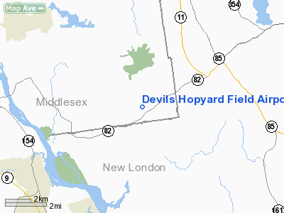
Devils Hopyard Field Airport |
Location
& QuickFacts
|
FAA
Information Effective: |
2006-09-28 |
|
Airport
Identifier: |
CT11 |
|
Longitude/Latitude: |
072-20-20.2990W/41-26-38.3540N
-72.338972/41.443987 (Estimated) |
|
Elevation: |
125 ft / 38.10 m (Estimated) |
|
Land: |
0 acres |
|
From
nearest city: |
0 nautical miles of East Haddam, CT |
|
Location: |
Middlesex County, CT |
|
Magnetic Variation: |
14W (1985) |
Owner
& Manager
|
Ownership: |
Privately owned |
|
Owner: |
Kevin C. Mazer |
|
Address: |
Salem Road
Old Lyme, CT 06371 |
|
Phone
number: |
203-434-8022 |
|
Manager: |
Kevin C. Mazer |
|
Address: |
Salem Road
Old Lyme, CT 06371 |
|
Phone number: |
203-434-8022 |
Airport
Operations and Facilities
|
Airport Use: |
Private |
|
Wind indicator: |
Yes |
|
Segmented Circle: |
No |
|
Control Tower: |
No |
|
Attendance Schedule: |
IREG |
|
Landing fee charge: |
No |
|
Sectional chart: |
New York |
|
Region: |
ANE - New England |
|
Boundary ARTCC: |
ZBW - Boston |
|
Tie-in FSS: |
BDR - Bridgeport |
|
FSS on Airport: |
No |
|
FSS Phone: |
866-293-5149 |
|
FSS Toll Free: |
1-800-WX-BRIEF |
Airport
Services
|
Airframe
Repair: |
NONE |
|
Power
Plant Repair: |
NONE |
|
Runway Information
Runway N/S
|
Dimension: |
1250 x 200 ft / 381.0 x 61.0 m |
|
Surface: |
TURF, |
|
|
Runway N |
Runway S |
|
Traffic
Pattern: |
Left |
Left |
|
Radio Navigation
Aids
|
ID |
Type |
Name |
Ch |
Freq |
Var |
Dist |
|
HF |
NDB |
Lomis |
|
244.00 |
15W |
17.3 nm |
|
MMK |
NDB |
Meriden |
|
238.00 |
14W |
22.4 nm |
|
TBY |
NDB |
Waterbury |
|
257.00 |
14W |
36.6 nm |
|
OP |
NDB |
Old Field Point Light |
|
316.00 |
13W |
45.1 nm |
|
SFZ |
NDB |
Central |
|
241.00 |
15W |
47.7 nm |
|
FOK |
TACAN |
Suffolk Co |
047X |
|
13W |
38.8 nm |
|
GON |
VOR/DME |
Groton |
45Y |
110.85 |
14W |
14.6 nm |
|
HFD |
VOR/DME |
Hartford |
096X |
114.90 |
13W |
15.1 nm |
|
ORW |
VOR/DME |
Norwich |
037X |
110.00 |
14W |
16.7 nm |
|
MAD |
VOR/DME |
Madison |
041X |
110.40 |
13W |
17.7 nm |
|
HVN |
VOR/DME |
New Haven |
035X |
109.80 |
13W |
27.0 nm |
|
CCC |
VOR/DME |
Calverton |
119X |
117.20 |
13W |
37.3 nm |
|
PUT |
VOR/DME |
Putnam |
121X |
117.40 |
14W |
37.9 nm |
|
SEY |
VOR/DME |
Sandy Point |
125X |
117.80 |
15W |
38.2 nm |
|
BDR |
VOR/DME |
Bridgeport |
25X |
108.80 |
12W |
39.3 nm |
|
HTO |
VORTAC |
Hampton |
083X |
113.60 |
13W |
31.6 nm |
|
BDL |
VORTAC |
Bradley |
027X |
109.00 |
14W |
33.7 nm |
|
PVD |
VORTAC |
Providence |
103X |
115.60 |
14W |
44.2 nm |
|
CEF |
VORTAC |
Westover |
87X |
114.00 |
14W |
46.1 nm |
|
BAF |
VORTAC |
Barnes |
077X |
113.00 |
14W |
46.3 nm |
|
GON |
VOT |
Groton |
|
110.25 |
|
14.8 nm |
|
HFD |
VOT |
Hartford |
|
108.20 |
|
22.4 nm |
|
BDL |
VOT |
Bradley Intl |
|
111.40 |
|
33.5 nm |
|
BDR |
VOT |
Bridgeport |
|
109.25 |
|
39.4 nm |
|
PVD |
VOT |
Providence |
|
108.20 |
|
44.3 nm |
Remarks
Based Aircraft
|
Aircraft
based on field: |
2 |
|
Single
Engine Airplanes: |
2 |
Devils Hopyard Field Airport
Address:
Middlesex County, CT
Tel:
203-434-8022
Images
and information placed above are from
http://www.airport-data.com/airport/CT11/
We
thank them for the data!
| General
Info |
| Country |
United
States |
| State |
CONNECTICUT
|
| FAA ID |
CT11
|
| Latitude |
41-26-38.354N
|
| Longitude |
072-20-20.299W
|
| Elevation |
125 feet
|
| Near City |
EAST HADDAM
|
We don't guarantee the information is fresh and accurate. The data may
be wrong or outdated.
For more up-to-date information please refer to other sources.
|
|


