 |
|
Danbury Municipal Airport |
Coordinates: 41°22′18″N 073°28′56″W / 41.37167°N 73.48222°W / 41.37167; -73.48222
| Danbury Municipal Airport |
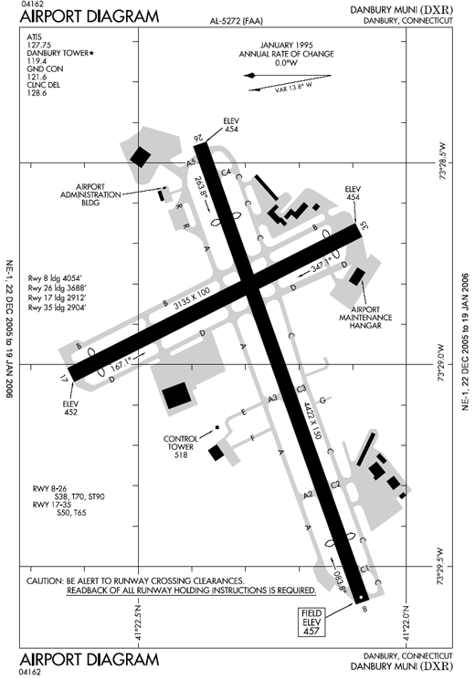 |
| FAA airport diagram |
| IATA: DXR – ICAO: KDXR – FAA LID: DXR |
| Summary |
| Airport type |
Public |
| Owner |
City of Danbury |
| Location |
Danbury, Connecticut |
| Elevation AMSL |
458 ft / 140 m |
| Runways |
| Direction |
Length |
Surface |
| ft |
m |
| 8/26 |
4,422 |
1,348 |
Asphalt |
| 17/35 |
3,135 |
956 |
Asphalt |
| Statistics (2007) |
| Aircraft operations |
79,282 |
| Based aircraft |
227 |
| Source: Federal Aviation Administration |
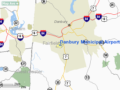
Danbury Municipal Airport (IATA: DXR, ICAO: KDXR, FAA LID: DXR) is a public use general aviation airport located three miles (5 km) southwest of the central business district of Danbury, in Fairfield County, Connecticut, United States. The airport opened in 1930. It is currently run by the city of Danbury.
The Reliant Air building burned down on the evening of September 12, 2007. The hangar was located on the northeast side of the airport.
Facilities and aircraft
Danbury Municipal Airport covers 248 acres (1.00 km) and has two runways:
- Runway 8/26: 4,422 x 150 ft (1,348 x 46 m), Surface: Asphalt
- Runway 17/35: 3,135 x 100 ft (956 x 30 m), Surface: Asphalt
The airport has three instrument approaches:
- Localizer Runway 8: Decision height - 643 feet (196 m) AGL
- VOR or GPS-A: Decision height - 902 feet (275 m) AGL
- GPS Runway 8: Decision height - 802 feet (244 m) AGL
For the 12-month period ending March 31, 2007, the airport had 79,282 aircraft operations, an average of 217 per day: 99% general aviation, <1% air taxi and <1% military. There are 227 aircraft based at this airport: 76% single engine, 21% multi-engine, 1% jet aircraft and 1% helicopters.
The above content comes from Wikipedia and is published under free licenses – click here to read more.
Location
& QuickFacts
|
FAA
Information Effective: |
2006-09-28 |
|
Airport
Identifier: |
DXR |
|
Longitude/Latitude: |
073-28-55.8860W/41-22-17.5270N
-73.482191/41.371535 (Estimated) |
|
Elevation: |
458 ft / 139.60 m (Surveyed) |
|
Land: |
248 acres |
|
From
nearest city: |
3 nautical miles SW of Danbury, CT |
|
Location: |
Fairfield County, CT |
|
Magnetic Variation: |
14W (1995) |
Owner
& Manager
|
Ownership: |
Publicly owned |
|
Owner: |
City Of Danbury |
|
Address: |
City Hall
Danbury, CT 06810 |
|
Phone
number: |
203-797-4500 |
|
Manager: |
Paul D. Estefan |
|
Address: |
P.o.box 2299
Danbury, CT 06813 |
|
Phone number: |
203-797-4624 |
Airport
Operations and Facilities
|
Airport
Use: |
Open to public |
|
Wind
indicator: |
Yes |
|
Segmented
Circle: |
Yes |
|
Control
Tower: |
Yes |
|
Attendance
Schedule: |
ALL/ALL/0700-DUSK |
|
Lighting
Schedule: |
DUSK-DAWN
ACTVT MIRL RWY 08/26 & REILS RWY 08 & 26 WHEN TWR
CLSD - 119.4. |
|
Beacon
Color: |
Clear-Green (lighted land airport)
ROTG BCN LCTD ONE MILE SOUTH OF ARPT ON TOP OF A HILL. |
|
Landing
fee charge: |
No |
|
Sectional
chart: |
New York |
|
Region: |
ANE - New England |
|
Traffic
Pattern Alt: |
1243 ft |
|
Boundary
ARTCC: |
ZBW - Boston |
|
Responsible
ARTCC: |
ZNY - New York |
|
Tie-in
FSS: |
BDR - Bridgeport |
|
FSS
on Airport: |
No |
|
FSS
Phone: |
866-293-5149 |
|
FSS
Toll Free: |
1-800-WX-BRIEF |
|
NOTAMs
Facility: |
DXR (NOTAM-d service avaliable) |
|
Certification
type/date: |
I LU 11/1974
PPR 24 HRS FOR UNSKED ACR OPNS WITH MORE THAN 30 PSGR SEATS;
CALL AMGR 203-797-4624. |
|
Federal Agreements: |
NGY3 |
Airport
Communications
|
CTAF: |
119.400 |
|
Unicom: |
122.950 |
Airport
Services
|
Fuel
available: |
100LLA |
|
Airframe
Repair: |
MAJOR |
|
Power
Plant Repair: |
MAJOR |
|
Bottled
Oxygen: |
LOW |
|
Bulk
Oxygen: |
NONE |
|
Runway Information
Runway 08/26
|
Dimension: |
4422 x 150 ft / 1347.8 x 45.7 m |
|
Surface: |
ASPH, Fair Condition |
|
Surface
Treatment: |
Saw-cut or plastic Grooved |
|
Weight
Limit: |
Single wheel: 38000 lbs.
Dual wheel: 70000 lbs. |
|
Edge
Lights: |
Medium |
|
|
Runway 08 |
Runway 26 |
|
Longitude: |
073-29-26.7420W |
073-28-32.3280W |
|
Latitude: |
41-22-07.3080N |
41-22-22.4240N |
|
Elevation: |
457.00 ft |
454.00 ft |
|
Alignment: |
70 |
127 |
|
ILS
Type: |
LOC/DME |
|
|
Traffic
Pattern: |
Left |
Left |
|
Markings: |
Non-precision instrument, Good Condition |
Non-precision instrument, Good Condition |
|
Displaced
threshold: |
368.00 ft |
734.00 ft |
|
Runway
End Identifier: |
Yes |
Yes |
|
Centerline
Lights: |
No |
No |
|
Touchdown
Lights: |
No |
No |
|
Obstruction: |
15 ft trees, 230.0 ft from runway, 75 ft left
of centerline, 2:1 slope to clear
RWY 8 APCH RATIO 12:1 BASED ON DSPLCD THLD.
+9'
FENCE 170' FM THR. |
88 ft trees, 450.0 ft from runway, 100 ft right
of centerline, 3:1 slope to clear
APCH RATIO 11:1 TO DSPLCD THLD.
RWY
26 +6' FENCE 75' FROM THLD. |
|
Runway 17/35
|
Dimension: |
3135 x 100 ft / 955.5 x 30.5 m |
|
Surface: |
ASPH, Good Condition |
|
Weight
Limit: |
Single wheel: 50000 lbs.
Dual wheel: 65000 lbs. |
|
|
Runway 17 |
Runway 35 |
|
Longitude: |
073-29-00.0420W |
073-28-41.4360W |
|
Latitude: |
41-22-35.0890N |
41-22-07.4670N |
|
Elevation: |
452.00 ft |
454.00 ft |
|
Alignment: |
127 |
127 |
|
Traffic
Pattern: |
Left |
Left |
|
Markings: |
Basic, Good Condition |
Basic, Good Condition |
|
Displaced
threshold: |
223.00 ft |
231.00 ft |
|
Runway
End Identifier: |
No |
No |
|
Centerline
Lights: |
No |
No |
|
Touchdown
Lights: |
No |
No |
|
Obstruction: |
22 ft pole, 600.0 ft from runway, 150 ft left
of centerline, 18:1 slope to clear
APCH RATIO 28:1 TO DSPLCD THLD.
5 FT FENCE 50 FT FROM THR. +15 FT ROAD 94 FT FROM THR. |
30 ft trees, 350.0 ft from runway, 100 ft right
of centerline, 5:1 slope to clear
APCH RATIO 19:1 TO DSPLCD THLD.
+8 FT FENCE 150 FT FM THLD; +17 FT ROAD 120 FT FT THLD. |
|
Radio Navigation
Aids
|
ID |
Type |
Name |
Ch |
Freq |
Var |
Dist |
|
SKU |
FAN MARKER |
Stanwyck |
|
|
12W |
27.0 nm |
|
GBR |
FAN MARKER |
Sheffield |
|
|
13W |
45.8 nm |
|
TBY |
NDB |
Waterbury |
|
257.00 |
14W |
18.0 nm |
|
PO |
NDB |
Meier |
|
403.00 |
12W |
24.9 nm |
|
SKU |
NDB |
Stanwyck |
|
261.00 |
12W |
27.0 nm |
|
OP |
NDB |
Old Field Point Light |
|
316.00 |
13W |
28.9 nm |
|
MMK |
NDB |
Meriden |
|
238.00 |
14W |
30.6 nm |
|
SW |
NDB |
Neely |
|
335.00 |
14W |
34.3 nm |
|
PNJ |
NDB |
Paterson |
|
347.00 |
12W |
39.6 nm |
|
HF |
NDB |
Lomis |
|
244.00 |
15W |
41.7 nm |
|
BBN |
NDB |
Babylon |
|
275.00 |
14W |
42.3 nm |
|
GBR |
NDB |
Great Barrington |
|
395.00 |
14W |
48.9 nm |
|
CMK |
VOR/DME |
Carmel |
113X |
116.60 |
12W |
7.1 nm |
|
BDR |
VOR/DME |
Bridgeport |
25X |
108.80 |
12W |
20.5 nm |
|
IGN |
VOR/DME |
Kingston |
123X |
117.60 |
12W |
23.4 nm |
|
PWL |
VOR/DME |
Pawling |
090X |
114.30 |
12W |
24.5 nm |
|
HVN |
VOR/DME |
New Haven |
035X |
109.80 |
13W |
27.7 nm |
|
DPK |
VOR/DME |
Deer Park |
124X |
117.70 |
12W |
35.8 nm |
|
MAD |
VOR/DME |
Madison |
041X |
110.40 |
13W |
35.8 nm |
|
LGA |
VOR/DME |
La Guardia |
078X |
113.10 |
12W |
39.4 nm |
|
CCC |
VOR/DME |
Calverton |
119X |
117.20 |
13W |
40.8 nm |
|
TEB |
VOR/DME |
Teterboro |
021X |
108.40 |
11W |
41.0 nm |
|
HFD |
VOR/DME |
Hartford |
096X |
114.90 |
13W |
45.1 nm |
|
JFK |
VOR/DME |
Kennedy |
106X |
115.90 |
12W |
46.3 nm |
|
CRI |
VOR/DME |
Canarsie |
070X |
112.30 |
11W |
49.3 nm |
|
BDL |
VORTAC |
Bradley |
027X |
109.00 |
14W |
49.4 nm |
|
BDR |
VOT |
Bridgeport |
|
109.25 |
|
20.5 nm |
|
ISP |
VOT |
Long Island Mac Arthur |
|
109.40 |
|
39.2 nm |
|
HFD |
VOT |
Hartford |
|
108.20 |
|
43.3 nm |
|
JFK |
VOT |
Kennedy |
|
115.10 |
|
46.3 nm |
|
BDL |
VOT |
Bradley Intl |
|
111.40 |
|
49.5 nm |
Remarks
-
< NATURAL
TO DUE FINAL 2MI 1 APCHG TIL LEG BASE ON 1300? BLO DESCENDING TWR THE
FM VISIBLE NOT ARE 35 RWY USING>
- PROHIBITED
TO ULTRALIGHT & UNREGISTERED ACFT.
- DEER
& BIRDS ON & INVOF ARPT.
- INTXN
ECTION TKOFS; STOP & GO TKOFS NOT AUZD.
- PPR
FOR FORMATION TKOF/LDG; CTC AMGR.
- LDG
DISTANCE AVBL NON-STD; PART 121 & 135 OPNS MUST COMPUTE EFFECTIVE
RY LENGTHS. ALL OTHERS BE AWARE REMAINING RY LENGTH AVBL AFTER CLEARING
CONTROLLING OBSTN RYS 08 & 26 MAY BE INSUFFICIENT DEPENDING ON TYPE
ACFT.
- NOISE
ABATEMENT PROCEDURES IN EFFECT CTC AMGR 203-797-4624.
- ARPT
CLSD TO AIR CARRIER OPNS WITH MORE THAN 30 PASSENGER SEATS.
- EXISTED
PRIOR TO 1959.
Based Aircraft
|
Aircraft
based on field: |
227 |
|
Single
Engine Airplanes: |
173 |
|
Multi
Engine Airplanes: |
48 |
|
Jet Engine
Airplanes: |
3 |
|
Helicopters: |
3 |
Operational Statistics
|
Aircraft
Operations: |
244/Day |
|
Air Taxi: |
0.2% |
|
General
Aviation Local: |
48.6% |
|
General
Aviation Itinerant: |
51.2% |
|
Military: |
0.0% |
Danbury Municipal Airport
Address:
Fairfield County, CT
Tel:
203-797-4500,
203-797-4624
Images
and information placed above are from
http://www.airport-data.com/airport/DXR/
We
thank them for the data!
| General
Info |
| Country |
United
States |
| State |
CONNECTICUT
|
| FAA ID |
DXR
|
| Latitude |
41-22-17.527N
|
| Longitude |
073-28-55.886W
|
| Elevation |
458 feet
|
| Near City |
DANBURY
|
We don't guarantee the information is fresh and accurate. The data may
be wrong or outdated.
For more up-to-date information please refer to other sources.
|
|


