|
|
Coordinates: 33°48′12″N 118°20′23″W / 33.80333°N 118.33972°W / 33.80333; -118.33972
| Zamperini Field |
 |
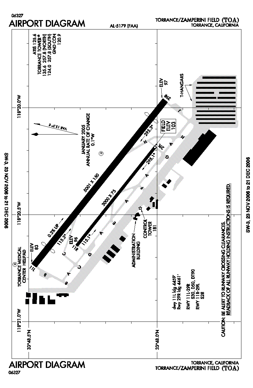
| FAA airport diagram |
| IATA: TOA – ICAO: KTOA – FAA LID: TOA |
| Summary |
| Airport type |
Public |
| Owner |
City of Torrance |
| Location |
Torrance, California |
| Elevation AMSL |
103 ft / 31 m |
| Website |
www.ci.torrance.ca.us/... |
| Runways |
| Direction |
Length |
Surface |
| ft |
m |
| 11L/29R |
5,000 |
1,524 |
Asphalt/Concrete |
| 11R/29L |
3,000 |
914 |
Asphalt/Concrete |
| Helipads |
| Number |
Length |
Surface |
| ft |
m |
| HI |
110 |
34 |
Asphalt |
| Statistics (2005) |
| Aircraft operations |
173,027 |
| Based aircraft |
499 |
| Source: Federal Aviation Administration |
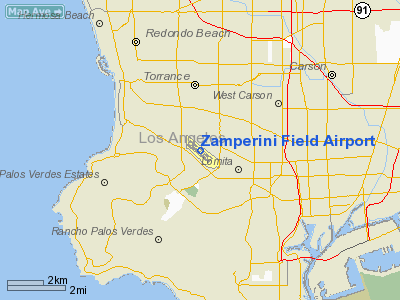
Zamperini Field (IATA: TOA, ICAO: KTOA, FAA LID: TOA) is a city-owned public-use airport located three miles (5 km) southwest of the central business district of Torrance, in Los Angeles County, California, United States.
The airport, one of the busiest general aviation airports in the state and once known as Torrance Municipal Airport, was renamed in honor of local sports and war hero Louis Zamperini. Facilities and aircraft
Zamperini Field covers an area of 506 acres (205 ha) which contains two asphalt and concrete paved runways: 11L/29R measuring 5,000 x 150 ft (1,524 x 46 m) and 11R/29L measuring 3,000 x 75 ft (914 x 23 m). It also contain one asphalt paved helipad measuring 110 x 110 ft (34 x 34 m).
For the 12-month period ending May 31, 2005, the airport had 173,027 aircraft operations, an average of 474 per day: 99% general aviation, 1% military and <1% air taxi. There are 499 aircraft based at this airport: 89% single-engine, 8% multi-engine, 2% helicopter and <1% glider.
Helicopter operations
The helipad for a neighboring hospital, the Torrance Medical Center, is located at the north-west corner of the Zamperini Field airfield.
Manufacturing
Zamperini Field is the home of Robinson Helicopter Company. Their entire production, assembly, and testing facilities are located on the southeast side of the airfield, and are the largest buildings at the airport.
Museum
Zamperini Field is the new home of the Western Museum of Flight, which was previously in Hawthorne, California.
Accidents and incidents
- Aeroméxico Flight 498 Cerritos air disaster: A private Piper Cherokee owned by William Kramer en route to Big Bear City Airport near Big Bear Lake from Torrance collided with a Douglas DC-9 owned by Aeroméxico en route to Los Angeles International Airport from various Mexican cities. Both planes crashed, causing all of the people on both planes to die and some residents in Cerritos to die or sustain injuries.
History
The airport was built by the United States Army Air Force about 1942, and was known as Lomita Flight Strip. It was an emergency landing airfield for military aircraft on training flights. It was closed after World War II, and was turned over for local government use by the War Assets Administration (WAA).
The above content comes from Wikipedia and is published under free licenses – click here to read more.
|
 |
(Click on the photo to enlarge) |
Location
& QuickFacts
|
FAA
Information Effective: |
2006-09-28 |
|
Airport
Identifier: |
TOA |
|
Longitude/Latitude: |
118-20-22.6000W/33-48-12.2100N
-118.339611/33.803392 (Estimated) |
|
Elevation: |
103 ft / 31.39 m (Surveyed) |
|
Land: |
506 acres |
|
From
nearest city: |
3 nautical miles SW of Torrance, CA |
|
Location: |
Los Angeles County, CA |
|
Magnetic Variation: |
14E (1985) |
Owner
& Manager
|
Ownership: |
Publicly owned |
|
Owner: |
City Of Torrance |
|
Address: |
3031 Torrance Blvd
Torrance, CA 90503 |
|
Phone
number: |
310-618-5880 |
|
Manager: |
Jack Van Der Linden |
|
Address: |
City Of Torrance, 20500 Madrona Avenue
Torrance, CA 90503 |
|
Phone number: |
310-784-7908 |
Airport
Operations and Facilities
|
Airport
Use: |
Open to public |
|
Wind
indicator: |
Yes |
|
Segmented
Circle: |
Yes |
|
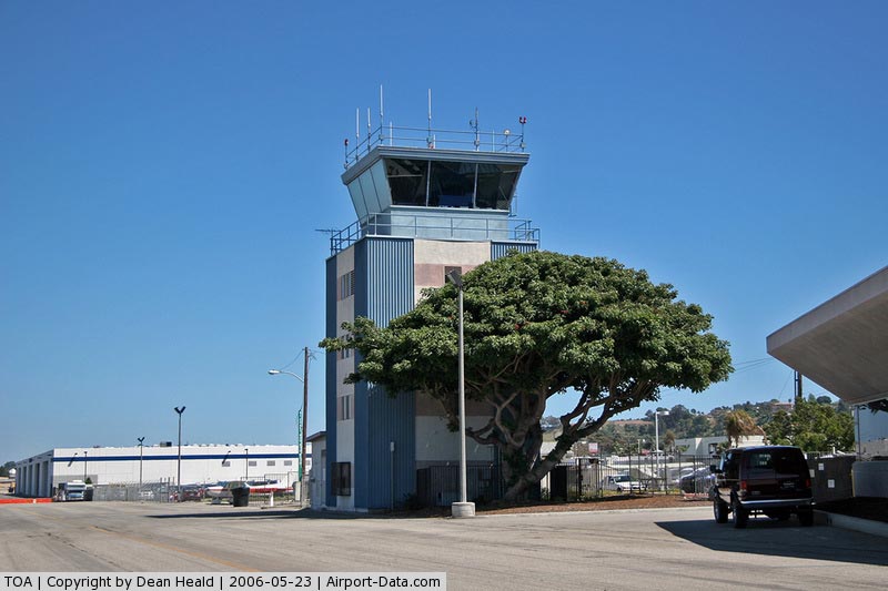
Control
Tower: |
Yes |
|
Attendance
Schedule: |
ALL/ALL/0600-2200 |
|
Lighting
Schedule: |
DUSK-DAWN
WHEN ATCT CLSD ACTVT MALSR RY 29R - CTAF; MIRL RY 11L/29R
SS-SR; MIRL RY 11R/29L 0600-2000; ACTVT HELIPAD PERIMETER
LGTS - 24 HRS - CTAF. |
|
Beacon
Color: |
Clear-Green (lighted land airport) |
|
Landing
fee charge: |
No |
|
Sectional
chart: |
Los Angeles |
|
Region: |
AWP - Western-Pacific |
|
Traffic
Pattern Alt: |
1000 ft |
|
Boundary
ARTCC: |
ZLA - Los Angeles |
|
Tie-in
FSS: |
HHR - Hawthorne |
|
FSS
on Airport: |
No |
|
FSS
Phone: |
310-970-0102 |
|
FSS
Toll Free: |
1-800-WX-BRIEF |
|
NOTAMs
Facility: |
TOA (NOTAM-d service avaliable) |
|
Federal Agreements: |
NY1 |
Airport
Communications
|
CTAF: |
124.000 |
|
Unicom: |
122.950 |
Airport
Services
|
Fuel
available: |
100LL80
FUEL AVBL 0700-2000. |
|
Airframe
Repair: |
MAJOR |
|
Power
Plant Repair: |
MAJOR |
|
Bottled
Oxygen: |
HIGH/LOW |
|
Bulk
Oxygen: |
HIGH/LOW |
|
Runway Information
Runway 11L/29R
|
Dimension: |
5001 x 150 ft / 1524.3 x 45.7 m |
|
Surface: |
ASPH-CONC, Fair Condition |
|
Weight
Limit: |
Single wheel: 30000 lbs.
Dual wheel: 50000 lbs.
Dual
tandem wheel: 90000 lbs. |
|
Edge
Lights: |
Medium
YELLOW PERIMETER LGTS. |
|
|
Runway 11L |
Runway 29R |
|
Longitude: |
118-20-44.3965W |
118-19-57.9901W |
|
Latitude: |
33-48-29.0026N |
33-47-58.2335N |
|
Elevation: |
83.00 ft |
97.00 ft |
|
Alignment: |
127 |
127 |
|
ILS
Type: |
|
ILS/DME |
|
Traffic
Pattern: |
Left |
Right |
|
Markings: |
Precision instrument, Fair Condition |
Precision instrument, Fair Condition |
|
Crossing
Height: |
10.00 ft |
11.00 ft |
|
Displaced
threshold: |
541.00 ft |
540.00 ft |
|
VASI: |
2-box on left side |
4-box on left side |
|
Visual
Glide Angle: |
3.50� |
4.00� |
|
Approach
lights: |
|
MALSR |
|
Runway
End Identifier: |
No |
No |
|
Centerline
Lights: |
No |
No |
|
Touchdown
Lights: |
No |
No |
|
Obstruction: |
35 ft trees, 690.0 ft from runway, 14:1 slope
to clear
RWY 11L APCH RATIO TO DSPLCD THR 35:1; |
22 ft bldg, 475.0 ft from runway, 530 ft left
of centerline, 12:1 slope to clear
APCH RATIO 46:1 TO DSPLCD THLD.
+9 FT MALSR BLDG 190 FT FROM E OR 440 FT RIGHT. |
|
Runway 11R/29L
|
Dimension: |
3000 x 75 ft / 914.4 x 22.9 m |
|
Surface: |
ASPH-CONC, Fair Condition |
|
Weight
Limit: |
Single wheel: 28000 lbs. |
|
Edge
Lights: |
Medium
YELLOW PERIMETER LGTS. |
|
|
Runway 11R |
Runway 29L |
|
Longitude: |
118-20-38.8047W |
118-20-10.9663W |
|
Latitude: |
33-48-18.9804N |
33-48-00.5232N |
|
Elevation: |
96.00 ft |
103.00 ft |
|
Alignment: |
127 |
127 |
|
Traffic
Pattern: |
Right |
Left |
|
Markings: |
Basic, Fair Condition |
Basic, Fair Condition |
|
Crossing
Height: |
0.00 ft |
25.00 ft |
|
VASI: |
|
2-box on left side |
|
Visual
Glide Angle: |
0.00� |
4.00� |
|
Runway
End Identifier: |
|
Yes |
|
Centerline
Lights: |
No |
No |
|
Touchdown
Lights: |
No |
No |
|
Obstruction: |
, 50:1 slope to clear |
26 ft bldg, 1400.0 ft from runway, 100 ft left
of centerline, 46:1 slope to clear |
|
Helipad HI
|
Dimension: |
110 x 110 ft / 33.5 x 33.5 m |
|
Surface: |
ASPH, Good Condition |
|
|
Runway HI |
Runway |
|
Traffic
Pattern: |
Left |
Left |
|
Radio Navigation
Aids
|
ID |
Type |
Name |
Ch |
Freq |
Var |
Dist |
|
CPM |
NDB |
Compton |
|
378.00 |
15E |
6.9 nm |
|
EMT |
NDB |
El Monte |
|
359.00 |
15E |
23.0 nm |
|
PAI |
NDB |
Pacoima |
|
370.00 |
15E |
27.7 nm |
|
NUC |
NDB |
San Clemente |
|
350.00 |
15E |
48.1 nm |
|
NTD |
TACAN |
Point Mugu |
043X |
|
15E |
43.5 nm |
|
NUC |
TACAN |
San Clemente |
123X |
|
15E |
48.2 nm |
|
RAL |
VOR |
Riverside |
|
112.40 |
15E |
45.3 nm |
|
SMO |
VOR/DME |
Santa Monica |
045X |
110.80 |
15E |
13.7 nm |
|
VNY |
VOR/DME |
Van Nuys |
078X |
113.10 |
15E |
26.4 nm |
|
ELB |
VOR/DME |
El Toro |
119X |
117.20 |
14E |
31.4 nm |
|
VTU |
VOR/DME |
Ventura |
019X |
108.20 |
15E |
40.0 nm |
|
CMA |
VOR/DME |
Camarillo |
105X |
115.80 |
15E |
44.9 nm |
|
LAX |
VORTAC |
Los Angeles |
083X |
113.60 |
15E |
9.1 nm |
|
SLI |
VORTAC |
Seal Beach |
104X |
115.70 |
15E |
14.3 nm |
|
SXC |
VORTAC |
Santa Catalina |
051X |
111.40 |
15E |
26.1 nm |
|
POM |
VORTAC |
Pomona |
041X |
110.40 |
15E |
32.1 nm |
|
PDZ |
VORTAC |
Paradise |
059X |
112.20 |
15E |
41.0 nm |
|
FIM |
VORTAC |
Fillmore |
072X |
112.50 |
15E |
42.8 nm |
|
LAX |
VOT |
San Pedro Hill |
|
113.90 |
|
3.5 nm |
|
SNA |
VOT |
Santa Ana |
|
110.00 |
|
24.7 nm |
Remarks
-
NUMEROUS
FLOCKS OF BIRDS ON AND INVOF ARPT.
-
TGL-STOP/GO
LNDG & LOW APCH OPNS & TAXI-BACK OPNS LTD TO 0800-2000 (TAXI-BACK
UNTIL 2200) WKDAYS & 1000-1700 SAT. NO TGL-STOP/GO LNDG & LOW
APCH OPNS & TAXI-BACK OPNS ON SUN & HOLS. ARPT CLSD TO DEP 2200-0700 WKDAYS & 2200-0800 WKENDS
& HOLS.
-
NO MULTI-ENGINE
SIMULATED ENGINE-OUT PROCS AUTH IN TFC PAT. RY 11R/29L CLSD 2000-0700.
-
NOISE SENSITIVE
AREA ALL QUADS. FOR NOISE ABATEMENT PROCEDURES INFO CTC ARPT NOISE ABATEMENT
(310) 784-7950 OR FREQ 122.9. CERTAIN
TURBO JET ACFT PERMLY EXCLUDED.
-
TWYS CROSS
APCH ZONE BOTH ENDS RWY 11R/29L OBSERVE TWY HOLD LINES.
-
CAUTION:
FARM EQUIPMENT OPERG NEAR ALL RWYS AND TWYS.
Based Aircraft
|
Aircraft
based on field: |
499 |
|
Single
Engine Airplanes: |
444 |
|
Multi
Engine Airplanes: |
42 |
|
Helicopters: |
11 |
|
Gliders: |
2 |
Operational Statistics
|
Aircraft
Operations: |
475/Day |
|
Air Taxi: |
0.1% |
|
General
Aviation Local: |
44.2% |
|
General
Aviation Itinerant: |
54.8% |
|
Military: |
0.9% |
Zamperini Field Airport
Address:
Los Angeles County, CA
Tel:
310-618-5880,
310-784-790
Images
and information placed above are from
http://www.airport-data.com/airport/TOA/
We
thank them for the data!
| General
Info |
| Country |
United
States |
| State |
CALIFORNIA
|
| FAA ID |
TOA
|
| Latitude |
33-48-12.210N
|
| Longitude |
118-20-22.600W
|
| Elevation |
103 feet
|
| Near City |
TORRANCE
|
We don't guarantee the information is fresh and accurate. The data may
be wrong or outdated.
For more up-to-date information please refer to other sources.
|
|