|
|
Westover Field Amador County Airport |
Amador County Airport
Westover Field |
 |
| IATA: none – ICAO: KJAQ – FAA LID: JAQ |
| Summary |
| Airport type |
Public |
| Owner |
County of Amador |
| Serves |
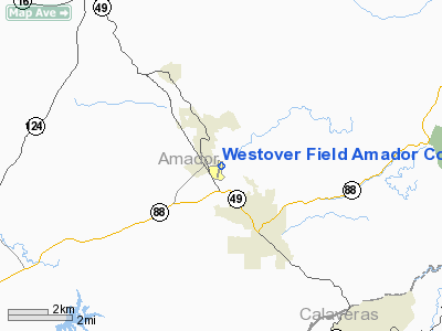
Jackson, California |
| Elevation AMSL |
1,690 ft / 515 m |
| Coordinates |
38°22′36″N 120°47′38″W / 38.37667°N 120.79389°W / 38.37667; -120.79389 |
| Runways |
| Direction |
Length |
Surface |
| ft |
m |
| 1/19 |
3,401 |
1,037 |
Asphalt |
| Statistics (1997) |
| Aircraft operations |
25,000 |
| Based aircraft |
89 |
| Source: Federal Aviation Administration |
Amador County Airport (ICAO: KJAQ, FAA LID: JAQ, formerly O70), also known as Westover Field, is a county-owned public-use airport in Amador County, California, United States. It is located two nautical miles (3.7 km) northwest of the central business district of Jackson, California. The airport is mostly used for general aviation.
Although many U.S. airports use the same three-letter location identifier for the FAA and IATA, this facility is assigned JAQ by the FAA but has no designation from the IATA (which assigned JAQ to Jacquinot Bay Airport in Papua New Guinea).
Facilities and aircraft
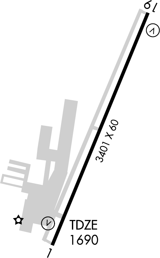
Amador County Airport covers an area of 110 acres (45 ha) at an elevation of 1,690 feet (515 m) above mean sea level. It has one runway designated 1/19 with an asphalt surface measuring 3,401 by 60 feet (1,037 x 18 m).
For the 12-month period ending October 1, 1997, the airport had 25,000 aircraft operations, an average of 68 per day: 99% general aviation, <1% air taxi, and <1% military. At that time there were 89 aircraft based at this airport: 88% single-engine, 5% multi-engine, 3% helicopter and 5% ultralight.
The above content comes from Wikipedia and is published under free licenses – click here to read more.
Location
& QuickFacts
|
FAA
Information Effective: |
2006-09-28 |
|
Airport
Identifier: |
O70 |
|
Longitude/Latitude: |
120-47-38.1000W/38-22-36.5000N
-120.793917/38.376806 (Estimated) |
|
Elevation: |
1690 ft / 515.11 m (Surveyed) |
|
Land: |
110 acres |
|
From
nearest city: |
2 nautical miles NW of Jackson, CA |
|
Location: |
Amador County, CA |
|
Magnetic Variation: |
16E (1990) |
Owner
& Manager
|
Ownership: |
Publicly owned |
|
Owner: |
County Of Amador |
|
Address: |
12200 Airport Rd
Jackson, CA 95642-9527 |
|
Phone number: |
209-223-6375 |
|
Manager: |
Dave Sheppard |
|
Address: |
12200 Airport Rd
Jackson, CA 95642 |
|
Phone number: |
209-223-2376 |
Airport
Operations and Facilities
|
Airport
Use: |
Open to public |
|
Wind
indicator: |
Yes |
|
Segmented
Circle: |
Yes |
|
Control
Tower: |
No |
|
Attendance
Schedule: |
ALL/ALL/0900-1700 |
|
Lighting
Schedule: |
DUSK-DAWN
ACTVT MIRL RY 01/19 - CTAF. |
|
Beacon
Color: |
Clear-Green (lighted land airport) |
|
Landing
fee charge: |
No |
|
Sectional
chart: |
San Francisco |
|
Region: |
AWP - Western-Pacific |
|
Traffic
Pattern Alt: |
1000 ft |
|
Boundary
ARTCC: |
ZOA - Oakland |
|
Tie-in
FSS: |
RIU - Rancho Murieta |
|
FSS
on Airport: |
No |
|
FSS
Phone: |
916-354-0161 |
|
FSS
Toll Free: |
1-800-WX-BRIEF |
|
NOTAMs
Facility: |
RIU (NOTAM-d service avaliable) |
|
Federal Agreements: |
NGY |
Airport
Communications
|
CTAF: |
122.800 |
|
Unicom: |
122.800 |
Airport
Services
|
Fuel
available: |
100LL |
|
Airframe
Repair: |
MAJOR |
|
Power
Plant Repair: |
MAJOR |
|
Bottled
Oxygen: |
NONE |
|
Bulk
Oxygen: |
NONE |
|
Runway Information
Runway 01/19
|
Dimension: |
3401 x 60 ft / 1036.6 x 18.3 m |
|
Surface: |
ASPH, Good Condition |
|
Weight
Limit: |
Single wheel: 12500 lbs. |
|
Edge
Lights: |
Medium |
|
|
Runway 01 |
Runway 19 |
|
Longitude: |
120-47-46.0789W |
120-47-30.0639W |
|
Latitude: |
38-22-20.9040N |
38-22-52.0699N |
|
Elevation: |
1691.00 ft |
1684.00 ft |
|
Alignment: |
22 |
127 |
|
Traffic
Pattern: |
Left |
Left |
|
Markings: |
Basic, Good Condition |
Basic, Good Condition |
|
Crossing
Height: |
28.00 ft |
38.00 ft |
|
VASI: |
2-box on left side |
2-box on left side |
|
Visual
Glide Angle: |
3.00� |
4.00� |
|
Runway
End Identifier: |
Yes |
Yes |
|
Obstruction: |
, 50:1 slope to clear |
75 ft tree, 1600.0 ft from runway, 250 ft left
of centerline, 18:1 slope to clear |
|
Radio Navigation
Aids
|
ID |
Type |
Name |
Ch |
Freq |
Var |
Dist |
|
TZZ |
VOR |
Travis |
|
116.40 |
17E |
48.0 nm |
|
HNW |
VOR/DME |
Hangtown |
102X |
115.50 |
17E |
21.0 nm |
|
MCC |
VOR/DME |
Mc Clellan |
029X |
109.20 |
17E |
33.6 nm |
|
MOD |
VOR/DME |
Modesto |
093X |
114.60 |
17E |
45.7 nm |
|
LIN |
VORTAC |
Linden |
095X |
114.80 |
17E |
20.7 nm |
|
SAC |
VORTAC |
Sacramento |
099X |
115.20 |
17E |
35.9 nm |
|
ECA |
VORTAC |
Manteca |
107X |
116.00 |
17E |
37.2 nm |
|
SAC |
VOT |
Sacramento Executive |
|
111.40 |
|
34.2 nm |
|
SMF |
VOT |
Sacramento Metropolitan |
|
111.40 |
|
42.0 nm |
Remarks
Based Aircraft
|
Aircraft
based on field: |
111 |
|
Single
Engine Airplanes: |
100 |
|
Multi
Engine Airplanes: |
4 |
|
Helicopters: |
3 |
|
Ultralights: |
4 |
Operational Statistics
|
Aircraft
Operations: |
69/Day |
|
Air Taxi: |
0.4% |
|
General
Aviation Local: |
49.6% |
|
General
Aviation Itinerant: |
49.6% |
|
Military: |
0.4% |
Westover Field Amador County Airport
Address:
Amador County, CA
Tel:
209-223-6375, 209-223-2376
Images
and information placed above are from
http://www.airport-data.com/airport/O70/
We
thank them for the data!
| General
Info |
| Country |
United
States |
| State |
CALIFORNIA
|
| FAA ID |
O70
|
| Latitude |
38-22-36.484N
|
| Longitude |
120-47-38.067W
|
| Elevation |
1690 feet
|
| Near City |
JACKSON
|
We don't guarantee the information is fresh and accurate. The data may
be wrong or outdated.
For more up-to-date information please refer to other sources.
|
|