 |
|
|
|
|
|
Location
& QuickFacts
|
FAA
Information Effective: |
2006-09-28 |
|
Airport
Identifier: |
92CA |
|
Longitude/Latitude: |
119-53-18.4780W/36-07-14.8270N
-119.888466/36.120785 (Estimated) |
|
Elevation: |
192 ft / 58.52 m (Estimated) |
|
Land: |
0 acres |
|
From
nearest city: |
5 nautical miles SW of Stratford, CA |
|
Location: |
Kings County, CA |
|
Magnetic Variation: |
15E (1985) |
Owner
& Manager
|
Ownership: |
Privately owned |
|
Owner: |
Westlake Farms Inc |
|
Address: |
23311 Newton Ave
Stratford, CA 93266 |
|
Phone number: |
559-947-3348 |
|
Manager: |
David Howe |
|
Address: |
23311 Newton Ave
Stratford, CA 93266 |
|
Phone number: |
559-924-6411 |
Airport
Operations and Facilities
|
Airport
Use: |
Private |
|
Wind
indicator: |
Yes |
|
Segmented
Circle: |
No |
|
Control
Tower: |
No |
|
Attendance
Schedule: |
UNATNDD |
|
Lighting
Schedule: |
PHONE REQ
FOR RWY LGTS CALL 209-947-3348. |
|
Landing
fee charge: |
No |
|
Sectional
chart: |
San Francisco |
|
Region: |
AWP - Western-Pacific |
|
Traffic
Pattern Alt: |
800 ft |
|
Boundary
ARTCC: |
ZOA - Oakland |
|
Tie-in FSS: |
RIU - Rancho Murieta |
|
FSS on Airport: |
No |
|
FSS Phone: |
916-354-0161 |
|
FSS Toll Free: |
1-800-WX-BRIEF |
Airport
Services
|
Airframe
Repair: |
NONE |
|
Power
Plant Repair: |
NONE |
|
Bottled
Oxygen: |
NONE |
|
Bulk
Oxygen: |
NONE |
|
Runway Information
Runway 14/32
|
Dimension: |
3600 x 50 ft / 1097.3 x 15.2 m |
|
Surface: |
ASPH, |
|
Edge
Lights: |
Medium |
|
|
Runway 14 |
Runway 32 |
|
Traffic
Pattern: |
Left |
Left |
|
Markings: |
Basic, Good Condition |
Basic, Good Condition |
|
Displaced
threshold: |
400.00 ft |
0.00 ft |
|
Runway
End Identifier: |
No |
No |
|
Centerline
Lights: |
No |
No |
|
Touchdown
Lights: |
No |
No |
|
Radio Navigation
Aids
|
ID |
Type |
Name |
Ch |
Freq |
Var |
Dist |
|
COR |
NDB |
Salyer Farms |
|
205.00 |
16E |
17.4 nm |
|
FCH |
NDB |
Chandler |
|
344.00 |
15E |
36.4 nm |
|
CUK |
NDB |
Academy |
|
266.00 |
14E |
38.6 nm |
|
NLC |
TACAN |
Lemoore |
080X |
|
16E |
13.9 nm |
|
ROM |
VOR |
Priest |
|
110.00 |
16E |
37.7 nm |
|
VIS |
VOR/DME |
Visalia |
031X |
109.40 |
16E |
24.6 nm |
|
TTE |
VOR/DME |
Tule |
029X |
109.20 |
16E |
44.0 nm |
|
AVE |
VORTAC |
Avenal |
118X |
117.10 |
16E |
28.8 nm |
|
PRB |
VORTAC |
Paso Robles |
090X |
114.30 |
16E |
44.9 nm |
|
CZQ |
VORTAC |
Clovis |
076X |
112.90 |
15E |
46.0 nm |
Remarks
-
NON COMPLIANCE WITH FAR
157.
Based Aircraft
|
Aircraft
based on field: |
3 |
|
Single
Engine Airplanes: |
3 |
Operational Statistics
|
Aircraft
Operations: |
20/Week |
|
General
Aviation Local: |
70.0% |
|
General
Aviation Itinerant: |
30.0% |
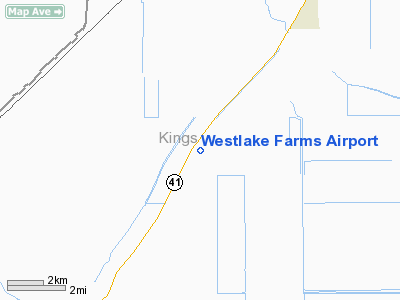
Westlake Farms Airport
Address:
Kings County, CA
Tel:
559-947-3348, 559-924-6411
Images
and information placed above are from
http://www.airport-data.com/airport/92CA/
We
thank them for the data!
| General
Info |
| Country |
United
States |
| State |
CALIFORNIA
|
| FAA ID |
92CA
|
| Latitude |
36-07-14.827N
|
| Longitude |
119-53-18.478W
|
| Elevation |
192 feet
|
| Near City |
STRATFORD
|
We don't guarantee the information is fresh and accurate. The data may
be wrong or outdated.
For more up-to-date information please refer to other sources.
|
|


