 |
|
| Weed Airport |
| IATA: none – ICAO: none – FAA LID: O46 |
| Summary |
| Airport type |
Public |
| Operator |
County of Siskiyou |
| Location |
Weed, California |
| Elevation AMSL |
2,938 ft / 895.5 m |
| Coordinates |
41°28′30″N 122°27′11″W / 41.475°N 122.45306°W / 41.475; -122.45306Coordinates: 41°28′30″N 122°27′11″W / 41.475°N 122.45306°W / 41.475; -122.45306 |
| Runways |
| Direction |
Length |
Surface |
| ft |
m |
| 14/32 |
5,000 |
1,524 |
Asphalt |
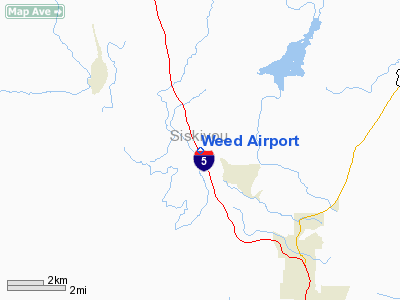
Weed Airport (FAA LID: O46) is a public airport located four miles (6.4 km) northwest of Weed, serving Siskiyou County, California, USA. This general aviation airport covers 344 acres (139 ha) and has one runway.
The above content comes from Wikipedia and is published under free licenses – click here to read more.
Location
& QuickFacts
|
FAA
Information Effective: |
2006-09-28 |
|
Airport
Identifier: |
O46 |
|
Longitude/Latitude: |
122-27-11.0660W/41-28-29.5320N
-122.453074/41.474870 (Estimated) |
|
Elevation: |
2938 ft / 895.50 m (Surveyed) |
|
Land: |
344 acres |
|
From
nearest city: |
4 nautical miles NW of Weed, CA |
|
Location: |
Siskiyou County, CA |
|
Magnetic Variation: |
18E (1985) |
Owner
& Manager
|
Ownership: |
Publicly owned |
|
Owner: |
County Of Siskiyou |
|
Address: |
305 Butte St
Yreka, CA 96097 |
|
Phone
number: |
530-842-8295 |
|
Manager: |
Thomas L. Anderson
DIR. OF ARPTS. |
|
Address: |
305 Butle Street
Yreka, CA 96097 |
|
Phone
number: |
530-842-8295
PHONE RINGS AT COUNTY AIRPORT OFFICE - YREKA |
Airport
Operations and Facilities
|
Airport
Use: |
Open to public |
|
Wind
indicator: |
Yes |
|
Segmented
Circle: |
Yes |
|
Control
Tower: |
No |
|
Attendance
Schedule: |
UNATNDD |
|
Lighting
Schedule: |
DUSK-DAWN
ACTVT MIRL RY 14/32 - CTAF. |
|
Beacon
Color: |
Clear-Green (lighted land airport) |
|
Landing
fee charge: |
Yes |
|
Sectional
chart: |
Klamath Falls |
|
Region: |
AWP - Western-Pacific |
|
Traffic
Pattern Alt: |
1000 ft |
|
Boundary
ARTCC: |
ZSE - Seattle |
|
Tie-in
FSS: |
RIU - Rancho Murieta |
|
FSS
on Airport: |
No |
|
FSS
Phone: |
916-354-0161 |
|
FSS
Toll Free: |
1-800-WX-BRIEF |
|
NOTAMs
Facility: |
RIU (NOTAM-d service avaliable) |
|
Federal Agreements: |
NGSY |
Airport
Communications
|
CTAF: |
122.700 |
|
Unicom: |
122.700 |
Airport
Services
|
Fuel
available: |
100LLA |
|
Airframe
Repair: |
NONE |
|
Power
Plant Repair: |
NONE |
|
Bottled
Oxygen: |
NONE |
|
Bulk
Oxygen: |
NONE |
|
Runway Information
Runway 14/32
|
Dimension: |
5000 x 60 ft / 1524.0 x 18.3 m |
|
Surface: |
ASPH, |
|
Surface
Treatment: |
Aggregate Friction Seal Coat |
|
Weight
Limit: |
Single wheel: 12000 lbs. |
|
Edge
Lights: |
Medium |
|
|
Runway 14 |
Runway 32 |
|
Elevation: |
2938.00 ft |
2939.00 ft |
|
Traffic
Pattern: |
Right |
Left |
|
Markings: |
Basic, Good Condition |
Basic, Good Condition |
|
Crossing
Height: |
23.00
ft |
20.00
ft |
|
VASI: |
2-box on left side |
2-box on left side |
|
Visual
Glide Angle: |
3.00� |
3.00� |
|
Runway
End Identifier: |
No |
No |
|
Centerline
Lights: |
No |
No |
|
Touchdown
Lights: |
No |
No |
|
Obstruction: |
, 50:1 slope to clear |
15 ft road, 900.0 ft from runway, 46:1 slope
to clear |
|
Radio Navigation
Aids
|
ID |
Type |
Name |
Ch |
Freq |
Var |
Dist |
|
MOG |
NDB |
Montague |
|
404.00 |
19E |
15.2 nm |
|
LFA |
NDB |
Merrill |
|
347.00 |
17E |
47.6 nm |
|
FJS |
VOR/DME |
Fort Jones |
033X |
109.60 |
19E |
16.0 nm |
Remarks
-
RAMP TAXIWAYS
CLSD NEAR MIDFIELD INTERSECTION AND NEAR SOUTH RAMP EXIT.
Based Aircraft
|
Aircraft
based on field: |
20 |
|
Single
Engine Airplanes: |
20 |
Operational Statistics
|
Aircraft
Operations: |
44/Day |
|
Air Taxi: |
0.3% |
|
General
Aviation Local: |
37.4% |
|
General
Aviation Itinerant: |
62.3% |
Weed Airport
Address:
Siskiyou County, CA
Tel:
530-842-8295
Images
and information placed above are from
http://www.airport-data.com/airport/O46/
We
thank them for the data!
| General
Info |
| Country |
United
States |
| State |
CALIFORNIA
|
| FAA ID |
O46
|
| Latitude |
41-28-29.532N
|
| Longitude |
122-27-11.066W
|
| Elevation |
2938 feet
|
| Near City |
WEED
|
We don't guarantee the information is fresh and accurate. The data may
be wrong or outdated.
For more up-to-date information please refer to other sources.
|
|


