|
 |
|
||||
|
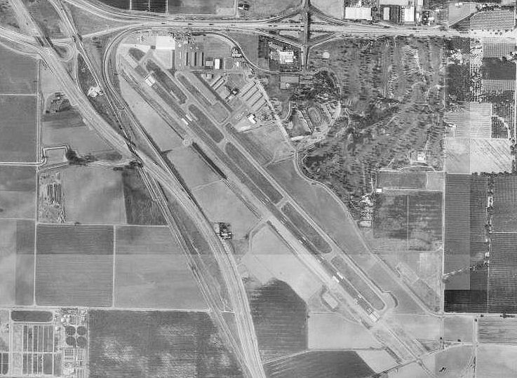
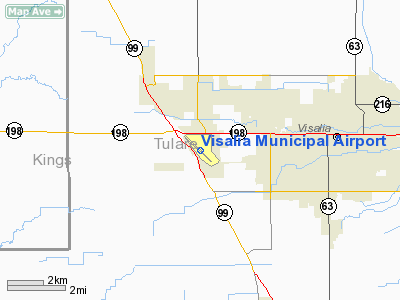
Visalia Municipal Airport (IATA: VIS, ICAO: KVIS, FAA LID: VIS) is a city-owned public-use airport located four nautical miles (7 km) west of the central business district of Visalia, a city in Tulare County, California, United States. The airport is served by one commercial airline which is subsidized by the Essential Air Service program. As per Federal Aviation Administration records, the airport had 1,696 passenger boardings (enplanements) in calendar year 2008, a decrease of 63% from the 4,637 enplanements in 2007. This airport is included in the FAA's National Plan of Integrated Airport Systems for 2009–2013, which categorized it as commercial service - non-primary. Based on 2008 enplanements it would be categorized as general aviation, since the commercial service category requires at least 2,500 enplanements per year. HistoryVisalia Municipal Airport was constructed in 1927. The following year, the Visalia Chamber of Commerce adopted a set of regulations pertaining to the safe and professional operation of the airfield. The field was purchased by the city in 1928. In 1936, the Works Progress Administration (WPA) began several projects at the Visalia Municipal Airport. The WPA would continue to make major improvements at field until 1942 when the War Department assumed control of the field with the onset of World War II. Unlike the construction of other military airfields of World War II, Visalia Army Airfield seems to have reutilized the existing municipal airport. Operations at Visalia AAF began almost immediately upon the United States Army Air Forces control of the airfield. Operational anti-submarine patrols were conducted from Visalia AAF by the Lockheed A-29 Hudson, and later B-25 Mitchell medium bombers, equipped 47th Bombardment Squadron (Medium) from February until June 1942. Visalia AAF (along with Hayward AAF and Palmdale AAF) was established as a sub-installations of Fresno's Hammer Field. As such, it shared Hammer Field's mission to train light, medium and heavy bomber squadrons. During that period Consolidated B-24 "Liberator", North American B-25 "Mitchell", Martin B-26 "Marauder" and the previously stated Lockheed A-29 "Hudson" bombers operated from Visalia AAF. In January 1944, the Headquarters, Army Air Forces ordered the entire Air University night fighter training program to California to be headquartered at Hammer Field. Under the overall supervision of Army Air Force School of Applied Tactics (AAFSAT) and the 481st Night Fighter Operational Training Group, night fighter crews were organized into Overseas Training Units and entered three phases of training. In all phases, Visalia AAF was used as a satellite training site. During this period, Douglas P-70 "Nighthawk" (heavy night fighter version of the A-20 "Havoc" light bomber) and Northrop P-61 "Black Widow" operated from Visalia AAF. It is known that the 425th Night Fighter Squadron stationed at Visalia AAF for its entire training cycle from February until May 1944 when it deployed to the European Theater at RAF Charmy Down, England as part of the Ninth Air Force. In 1946, the War Assets Administration, acting on behalf of the War Department, terminated the leases with the City of Visalia and other parties with the remainder of the lands transferred to the City of Visalia in 1947. The airport was featured in the 1993 film Son In Law in a scene where a American Eagle Airlines Saab 340 is shown landing at the airport. Facilities and aircraftVisalia Municipal Airport covers an area of 821 acres (332 ha) at an elevation of 295 feet (90 m) above mean sea level. It has one asphalt paved runway designated 12/30 which measures 6,559 by 150 feet (1,999 x 46 m). It also has one helipad with a 45 by 45 feet (14 x 14 m) asphalt surface. For the 12-month period ending March 31, 2009, the airport had 60,200 aircraft operations, an average of 164 per day: 58% general aviation, 42% air taxi, and <1% military. At that time there were 162 aircraft based at this airport: 77% single-engine, 18% multi-engine, 4% jet and 1% glider. Airline and destinations
The airport had been previously served by Air Midwest, Scenic Airlines, SkyWest Airlines, Swift Aire Lines, and Wings West Airlines. The above content comes from Wikipedia and is published under free licenses – click here to read more.
Runway InformationRunway 12/30
Helipad H1
Radio Navigation Aids
Remarks
Based Aircraft
Major Carriers Serving This Airport
Most Popular Destinations
Most Popular Aircraft
Operational Statistics
Visalia Municipal Airport Address: Tulare County, CA Tel: 559-713-4201, 559-713-4480 Images
and information placed above are from We thank them for the data!
We don't guarantee the information is fresh and accurate. The data may
be wrong or outdated. |
||||||||||||||||||||||||||||||||||||||||||||||||||||||||||||||||||||||||||||||||||||||||||||||||||||||||||||||||||||||||||||||||||||||||||||||||||||||||||||||||||||||||||||||||||||||||||||||||||||||||||||||||||||||||||||||||||||||||||||||||||||||||||||||||||||||||||||||||||||||||||||||||||||||||||||||||||||||||||||||||||||||||||||||||||||||||||||||||||||||||||||||||||||||||||||||||||||||||||||||||||||||||||||||||||||||||

 |
|
Copyright 2004-2024 © by Airports-Worldwide.com, Vyshenskoho st. 36, Lviv 79010, Ukraine Legal Disclaimer |