|
|
| Twentynine Palms Airport |
 |
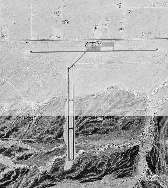
| USGS aerial image, 3 October 1995 |
| IATA: TNP – ICAO: KTNP – FAA LID: TNP |
| Summary |
| Airport type |
Public |
| Owner |
County of San Bernardino |
| Serves |
Twentynine Palms, California |
| Elevation AMSL |
1,888 ft / 575 m |
| Coordinates |
34°07′54″N 115°56′45″W / 34.13167°N 115.94583°W / 34.13167; -115.94583 |
| Runways |
| Direction |
Length |
Surface |
| ft |
m |
| 8/26 |
5,531 |
1,686 |
Asphalt |
| 17/35 |
3,797 |
1,157 |
Asphalt |
| Statistics (2006) |
| Aircraft operations |
18,000 |
| Based aircraft |
16 |
| Source: Federal Aviation Administration |
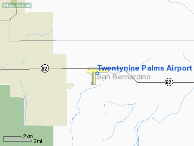
Twentynine Palms Airport (IATA: TNP, ICAO: KTNP, FAA LID: TNP) is a public use airport located six nautical miles (11 km) east of the central business district of Twentynine Palms, a city in San Bernardino County, California, United States. It is owned by the County of San Bernardino. History
Activated on 1 January 1942 by the United States Army Air Forces. Started as USAAF contract glider training - Twenty-Nine Palms Air Academy until 16 February 1943. Had four axillary airfields in local area. Flying training was performed with Fairchild PT-19s as the primary trainer. Also had several PT-17 Stearmans and a few P-40 Warhawks assigned. Conducted basic flying training from March 1943 until transferred to United States Navy April 1944; Under USN control became an axillary airfield to NAS San Diego.
Facilities and aircraft
Twentynine Palms Airport covers an area of 480 acres (194 ha) at an elevation of 1,888 feet (575 m) above mean sea level. It has two asphalt paved runways: 8/26 is 5,531 by 75 feet (1,686 x 23 m) and 17/35 is 3,797 by 50 feet (1,157 x 15 m).
For the 12-month period ending February 16, 2006, the airport had 18,000 aircraft operations, an average of 49 per day: 97.% general aviation and 3% military. At that time there were 16 aircraft based at this airport: 68% single-engine, 6% multi-engine and 25% glider.
The above content comes from Wikipedia and is published under free licenses – click here to read more.
Location
& QuickFacts
|
FAA
Information Effective: |
2006-09-28 |
|
Airport
Identifier: |
TNP |
|
Longitude/Latitude: |
115-56-44.9590W/34-07-53.7500N
-115.945822/34.131597 (Estimated) |
|
Elevation: |
1887 ft / 575.16 m (Surveyed) |
|
Land: |
480 acres |
|
From
nearest city: |
6 nautical miles E of Twentynine Palms, CA |
|
Location: |
San Bernardino County, CA |
|
Magnetic Variation: |
15E (1965) |
Owner
& Manager
|
Ownership: |
Publicly owned |
|
Owner: |
County Of San Bernardino |
|
Address: |
825 E 3rd St, Room 203
San Bernardino, CA 92415 |
|
Phone
number: |
909-387-7801 |
|
Manager: |
Terry Stover
BILL INGRAHAM AIPORTS DIRECTOR - PHONE (909) 387-7802 -
OFC LCTD APPLE VALLEY ARPT. |
|
Address: |
825 E. Third St., Room 203
San Bernardino, CA 92415-0831 |
|
Phone number: |
760-247-2371 |
Airport
Operations and Facilities
|
Airport
Use: |
Open to public |
|
Wind
indicator: |
Yes |
|
Segmented
Circle: |
Yes |
|
Control
Tower: |
No |
|
Attendance
Schedule: |
ALL/ALL/0800-1700 |
|
Lighting
Schedule: |
DUSK-DAWN
ACTVT MIRL RY 08/26 AND 17/35; REIL RY 08 AND RY 26 - CTAF. |
|
Beacon
Color: |
Clear-Green (lighted land airport) |
|
Landing
fee charge: |
No |
|
Sectional
chart: |
Los Angeles |
|
Region: |
AWP - Western-Pacific |
|
Traffic
Pattern Alt: |
1000 ft |
|
Boundary
ARTCC: |
ZLA - Los Angeles |
|
Tie-in
FSS: |
RAL - Riverside |
|
FSS
on Airport: |
No |
|
FSS
Phone: |
951-351-3020 |
|
FSS
Toll Free: |
1-800-WX-BRIEF |
|
NOTAMs
Facility: |
RAL (NOTAM-d service avaliable) |
|
Federal Agreements: |
NGSY |
Airport
Communications
|
CTAF: |
122.800 |
|
Unicom: |
122.800 |
Airport
Services
|
Fuel
available: |
100LL |
|
Airframe
Repair: |
MINOR |
|
Power
Plant Repair: |
MINOR |
|
Bottled
Oxygen: |
NONE |
|
Bulk
Oxygen: |
NONE |
|
Runway Information
Runway 08/26
|
Dimension: |
5531 x 75 ft / 1685.8 x 22.9 m |
|
Surface: |
ASPH, Good Condition |
|
Edge
Lights: |
Medium |
|
|
Runway 08 |
Runway 26 |
|
Longitude: |
115-57-12.3900W |
115-56-06.6000W |
|
Latitude: |
34-08-03.6500N |
34-08-03.9800N |
|
Elevation: |
1877.00 ft |
1787.00 ft |
|
Alignment: |
90 |
127 |
|
Traffic
Pattern: |
Left |
Left |
|
Markings: |
Basic, Good Condition |
Non-precision instrument, Good Condition |
|
Crossing
Height: |
40.00 ft |
40.00 ft |
|
VASI: |
2-light PAPI on left side |
2-light PAPI on left side |
|
Visual
Glide Angle: |
3.00� |
3.00� |
|
Runway
End Identifier: |
Yes
REIL RY 08 OTS INDEFLY. |
Yes
REIL RY 26 OTS INDEFLY. |
|
Centerline
Lights: |
No |
No |
|
Touchdown
Lights: |
No |
No |
|
Obstruction: |
120 ft pline, 4100.0 ft from runway, 32:1 slope
to clear |
, 50:1 slope to clear |
|
Runway 17/35
|
Dimension: |
3800 x 50 ft / 1158.2 x 15.2 m |
|
Surface: |
ASPH, Good Condition |
|
Edge
Lights: |
Medium |
|
|
Runway 17 |
Runway 35 |
|
Longitude: |
115-56-52.8540W |
115-56-52.9840W |
|
Latitude: |
34-07-57.8670N |
34-07-20.3100N |
|
Elevation: |
1854.00 ft |
1887.00 ft |
|
Alignment: |
127 |
0 |
|
Traffic
Pattern: |
Left |
Left |
|
Markings: |
Basic, Good Condition |
Basic, Good Condition |
|
Runway
End Identifier: |
No |
No |
|
Centerline
Lights: |
No |
No |
|
Touchdown
Lights: |
No |
No |
|
Obstruction: |
30 ft plines, 1400.0 ft from runway, 40:1 slope
to clear |
200 ft hill, 3300.0 ft from runway, 15:1 slope
to clear
+2' TERRAIN AT 200' FROM THR. |
|
Radio Navigation
Aids
|
ID |
Type |
Name |
Ch |
Freq |
Var |
Dist |
|
NXP |
TACAN |
Coyote |
063X |
|
14E |
14.5 nm |
|
TNP |
VORTAC |
Twentynine Palms |
089X |
114.20 |
15E |
8.8 nm |
|
PSP |
VORTAC |
Palm Springs |
102X |
115.50 |
13E |
28.8 nm |
|
TRM |
VORTAC |
Thermal |
109X |
116.20 |
13E |
32.1 nm |
|
HEC |
VORTAC |
Hector |
074X |
112.70 |
15E |
47.5 nm |
Remarks
-
TWY LGTS
ON TWY CONNECTING RWY 08/26 & RWY 17/35; PLUS BLUE REFLECTORS ON
PARALLEL TWY SERVING RWY 17/35.
Based Aircraft
|
Aircraft
based on field: |
17 |
|
Single
Engine Airplanes: |
12 |
|
Multi
Engine Airplanes: |
1 |
|
Gliders: |
4 |
Operational Statistics
|
Aircraft
Operations: |
50/Day |
|
General
Aviation Local: |
38.9% |
|
General
Aviation Itinerant: |
58.3% |
|
Military: |
2.8% |
Twentynine Palms Airport
Address:
San Bernardino County, CA
Tel:
909-387-7801,
760-247-2371
Images
and information placed above are from
http://www.airport-data.com/airport/TNP/
We
thank them for the data!
| General
Info |
| Country |
United
States |
| State |
CALIFORNIA
|
| FAA ID |
TNP
|
| Latitude |
34-07-55.507N
|
| Longitude |
115-56-44.995W
|
| Elevation |
1905 feet
|
| Near City |
TWENTYNINE
PALMS |
We don't guarantee the information is fresh and accurate. The data may
be wrong or outdated.
For more up-to-date information please refer to other sources.
|
|