 |
|
|
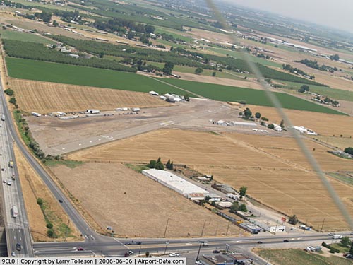 |
(Click on the photo to enlarge) |
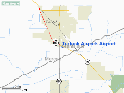
Location
& QuickFacts
|
FAA
Information Effective: |
2006-09-28 |
|
Airport
Identifier: |
9CL0 |
|
Longitude/Latitude: |
120-50-38.7380W/37-28-14.7660N
-120.844094/37.470768 (Estimated) |
|
Elevation: |
100 ft / 30.48 m (Estimated) |
|
Land: |
62 acres |
|
From
nearest city: |
2 nautical miles S of Turlock, CA |
|
Location: |
Stanislaus County, CA |
|
Magnetic Variation: |
16E (1985) |
Owner
& Manager
|
Ownership: |
Privately owned |
|
Owner: |
Turlock Airpark Inc |
|
Address: |
2050 Mira Flores Drive
Turlock, CA 95380 |
|
Phone number: |
209-667-2822 |
|
Address: |
|
Airport
Operations and Facilities
|
Airport
Use: |
Private |
|
Wind
indicator: |
Yes |
|
Segmented
Circle: |
No |
|
Control
Tower: |
No |
|
Attendance
Schedule: |
ALL/MON-SAT/0700-1800 |
|
Lighting
Schedule: |
RDO REQ
FOR RWY LGTS CALL TURLOCK AIRPORT 121.7. |
|
Landing fee charge: |
Yes |
|
Sectional chart: |
San Francisco |
|
Region: |
AWP - Western-Pacific |
|
Boundary ARTCC: |
ZOA - Oakland |
|
Tie-in FSS: |
RIU - Rancho Murieta |
|
FSS on Airport: |
No |
|
FSS Phone: |
916-354-0161 |
|
FSS Toll Free: |
1-800-WX-BRIEF |
Airport
Services
|
Fuel
available: |
100 80 |
|
Airframe
Repair: |
NONE |
|
Power
Plant Repair: |
NONE |
|
Runway Information
Runway 13/31
|
Dimension: |
2075 x 60 ft / 632.5 x 18.3 m |
|
Surface: |
ASPH, Poor Condition |
|
Weight
Limit: |
Single wheel: 4000 lbs. |
|
Edge
Lights: |
Low |
|
|
Runway 13 |
Runway 31 |
|
Traffic
Pattern: |
Left |
Left |
|
Markings: |
Basic, Poor Condition |
Basic, Poor Condition |
|
Displaced
threshold: |
440.00 ft |
300.00 ft |
|
Approach
lights: |
|
LDIN
LDIN LIGHTS ARE AMBER. |
|
Runway
End Identifier: |
No |
No |
|
Centerline
Lights: |
No |
No |
|
Touchdown
Lights: |
No |
No |
|
Obstruction: |
32 ft road, 200.0 ft from runway
APCH RATIO 16:1 TO EA DSPLCD THR RWY 13 & 31.
+15' POLES MKD & LGTD AT END OF RWY 200' APART STARTING
CNTRLN. +5' FENCE 50-150' FROM THR. +15' SHRUBS 50-60' FROM
THR. |
60 ft ant, 2000.0 ft from runway, 34:1 slope
to clear
+15' ROAD 5' FROM RWY END. |
|
Radio Navigation
Aids
|
ID |
Type |
Name |
Ch |
Freq |
Var |
Dist |
|
TCY |
NDB |
Tracy |
|
203.00 |
15E |
31.6 nm |
|
LV |
NDB |
Reiga |
|
374.00 |
16E |
42.2 nm |
|
MOD |
VOR/DME |
Modesto |
093X |
114.60 |
17E |
10.9 nm |
|
HYP |
VOR/DME |
El Nido |
089X |
114.20 |
15E |
26.0 nm |
|
ECA |
VORTAC |
Manteca |
107X |
116.00 |
17E |
26.8 nm |
|
LIN |
VORTAC |
Linden |
095X |
114.80 |
17E |
37.1 nm |
|
PXN |
VORTAC |
Panoche |
073X |
112.60 |
16E |
45.5 nm |
Remarks
-
1300 SE
RWY 13/31 USEABE RWY DUE TO OBSTRUCTIONS.
-
ESTABLISHED PRIOR TO
1959.
Based Aircraft
|
Aircraft
based on field: |
32 |
|
Single
Engine Airplanes: |
12 |
|
Ultralights: |
20 |
Operational Statistics
|
Aircraft
Operations: |
29/Week |
|
General
Aviation Local: |
60.0% |
|
General
Aviation Itinerant: |
40.0% |
Turlock Airpark Airport
Address:
Stanislaus County, CA
Tel:
209-667-282
Images
and information placed above are from
http://www.airport-data.com/airport/9CL0/
We
thank them for the data!
| General
Info |
| Country |
United
States |
| State |
CALIFORNIA
|
| FAA ID |
9CL0
|
| Latitude |
37-28-14.766N
|
| Longitude |
120-50-38.738W
|
| Elevation |
100 feet
|
| Near City |
TURLOCK
|
We don't guarantee the information is fresh and accurate. The data may
be wrong or outdated.
For more up-to-date information please refer to other sources.
|
|


