|
|
| Truckee Tahoe Airport |
 |
| IATA: TKF – ICAO: KTRK – FAA LID: TRK |
| Summary |
| Airport type |
Public |
| Owner |
Truckee Tahoe Airport District |
| Serves |
Truckee, California |
| Elevation AMSL |
5,900 ft / 1,798 m |
| Coordinates |
39°19′12″N 120°08′22″W / 39.32°N 120.13944°W / 39.32; -120.13944 |
| Website |
TruckeeTahoeAirport.com |
| Runways |
| Direction |
Length |
Surface |
| ft |
m |
| 10/28 |
7,000 |
2,134 |
Asphalt |
| 1/19 |
4,650 |
1,417 |
Asphalt |
| Statistics (2004) |
| Aircraft operations |
35,000 |
| Based aircraft |
91 |
| Sources: Airport website and FAA |
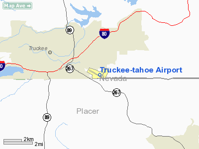
Truckee Tahoe Airport (IATA: TKF, ICAO: KTRK, FAA LID: TRK) is a public use airport located two nautical miles (3.7 km) east of the central business district of Truckee, California, United States. The airport is situated in both Nevada County and Placer County. It is owned by Truckee Tahoe Airport District, a bi-county special district. According to the FAA's National Plan of Integrated Airport Systems for 2009–2013, it is categorized as a general aviation airport.
Although many U.S. airports use the same three-letter location identifier for the FAA and IATA, this airport is assigned TRK by the FAA and TKF by the IATA (which assigned TRK to Juwata Airport in Tarakan, East Kalimantan, Indonesia). Facilities and aircraft
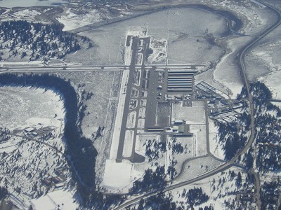
Truckee-Tahoe Airport covers an area of 989 acres (400 ha) at an elevation of 5,900 feet (1,798 m) above mean sea level. It has two asphalt paved runways: 10/28 is 7,000 by 100 feet (2,134 x 30 m) and 1/19 is 4,650 by 75 feet (1,417 x 23 m).
For the 12-month period ending December 31, 2004, the airport had 35,000 aircraft operations, an average of 95 per day: 97% general aviation, 3% air taxi, and <1% military. At that time there were 91 aircraft based at this airport: 80.2% single-engine, 13.2% multi-engine, 2.2% jet, 3.3% glider and 1.1% ultralight.
AWOS is at 118.0. Runway elevation 5,900'. Both runways are lighted. Density altitude can exceed 9,000' in summer months. Downdrafts can occur on final to RWY 19. Glider pilots use LEFT traffic RWY 19. Powered pilots use RIGHT traffic RWY 19.
100LL and Jet A are available from 7am - 7pm, and self serve 100LL is available from 7am - 9pm. There are 210 paved tie-downs available for transient parking, no landing fees, and minimal overnight tie-down fees.
The airport is attended seven days a week, 6am - 11pm. Snow removal equipment is operated round-the-clock to clear runways during and after snowstorms. Pre-heating services and aircraft maintenance are offered on the field by local FBOs. No de-icing services are available.
The Truckee Tahoe Airport had a 500 gallon underground heating oil tank removed in 1986. Small amounts of oil that had leaked out were monitored and removed under the supervision of the Nevada County Health Department and the Regional Water Quality Control Board. Six remaining aboveground tanks were functioning satisfactorily and are regularly leak tested.
Instrument Departures
IFR clearances can be requested from Oakland Center on frequency 127.95 which can be reached from most places on the field.
The above content comes from Wikipedia and is published under free licenses – click here to read more.
Location
& QuickFacts
|
FAA
Information Effective: |
2006-09-28 |
|
Airport
Identifier: |
TRK |
|
Longitude/Latitude: |
120-08-22.4260W/39-19-12.1520N
-120.139563/39.320042 (Estimated) |
|
Elevation: |
5900 ft / 1798.32 m (Surveyed) |
|
Land: |
989 acres |
|
From
nearest city: |
2 nautical miles E of Truckee, CA |
|
Location: |
Nevada County, CA |
|
Magnetic Variation: |
16E (2000) |
Owner
& Manager
|
Ownership: |
Publicly owned |
|
Owner: |
Truckee-tahoe Airport Dist |
|
Address: |
10356 Truckee Airport Rd
Truckee, CA 96161 |
|
Phone
number: |
530-587-4540 |
|
Manager: |
David V. Gotschall |
|
Address: |
10356 Truckee Airport Rd
Truckee, CA 96161 |
|
Phone number: |
530-587-4119 |
Airport
Operations and Facilities
|
Airport
Use: |
Open to public |
|
Wind
indicator: |
Yes |
|
Segmented
Circle: |
Yes |
|
Control
Tower: |
No |
|
Attendance
Schedule: |
ALL/ALL/0600-2300 |
|
Lighting
Schedule: |
DUSK-DAWN
ACTVT MIRL RY 1/19, RY 10/28 AND VASI RY 19 - CTAF. REIL
RY 10 AVBL ON REQ CTC UNICOM (0600-2300). |
|
Beacon
Color: |
Clear-Green (lighted land airport) |
|
Landing
fee charge: |
No |
|
Sectional
chart: |
San Francisco |
|
Region: |
AWP - Western-Pacific |
|
Traffic
Pattern Alt: |
1100 ft |
|
Boundary
ARTCC: |
ZOA - Oakland |
|
Tie-in
FSS: |
RNO - Reno |
|
FSS
on Airport: |
No |
|
FSS
Phone: |
775-858-1300 |
|
FSS
Toll Free: |
1-800-WX-BRIEF |
|
NOTAMs
Facility: |
TRK (NOTAM-d service avaliable) |
|
Federal Agreements: |
NGSY |
Airport
Communications
|
CTAF: |
122.800 |
|
Unicom: |
122.800 |
Airport
Services
|
Fuel
available: |
100LLA1+
FUEL AVAIL 0700-1900 (2200-SS 100LL ONLY.) |
|
Airframe
Repair: |
MAJOR |
|
Power
Plant Repair: |
MAJOR |
|
Bottled
Oxygen: |
HIGH/LOW |
|
Bulk
Oxygen: |
HIGH/LOW |
|
Runway Information
Runway 01/19
|
Dimension: |
4650 x 75 ft / 1417.3 x 22.9 m |
|
Surface: |
ASPH, Good Condition |
|
Weight
Limit: |
Single wheel: 12500 lbs. |
|
Edge
Lights: |
Medium |
|
|
Runway 01 |
Runway 19 |
|
Longitude: |
120-08-23.8990W |
120-07-54.3350W |
|
Latitude: |
39-18-52.2720N |
39-19-32.0680N |
|
Elevation: |
5886.00 ft |
5886.00 ft |
|
Alignment: |
30 |
127 |
|
Traffic
Pattern: |
Left |
Right |
|
Markings: |
Basic, Fair Condition |
Basic, Fair Condition |
|
Crossing
Height: |
0.00
ft |
30.00 ft |
|
Displaced
threshold: |
0.00
ft |
115.00 ft
RY 19 DSPLCD THLD NOT LGTD. RY 19 EDGE LGTS BEGIN 400 FT FM
EOR. |
|
VASI: |
|
2-box on left side |
|
Visual
Glide Angle: |
0.00� |
3.50� |
|
Runway
End Identifier: |
No |
No |
|
Centerline
Lights: |
No |
No |
|
Touchdown
Lights: |
No |
No |
|
Obstruction: |
225 ft tree, 4800.0 ft from runway, 20:1 slope
to clear
RWY 1 APCH RATIO 20:1 |
, 50:1 slope to clear
APCH RATIO TO DSPLCD THLD 50:1. |
|
Runway 10/28
|
Dimension: |
7000 x 100 ft / 2133.6 x 30.5 m |
|
Surface: |
ASPH, Good Condition |
|
Surface
Treatment: |
Saw-cut or plastic Grooved |
|
Weight
Limit: |
Single wheel: 60000 lbs.
Dual wheel: 100000 lbs. |
|
Edge
Lights: |
Medium |
|
|
Runway 10 |
Runway 28 |
|
Longitude: |
120-09-09.8320W |
120-07-52.7040W |
|
Latitude: |
39-19-29.4240N |
39-18-54.8500N |
|
Elevation: |
5897.00 ft |
5889.00 ft |
|
Alignment: |
120 |
127 |
|
Traffic
Pattern: |
Left |
Left |
|
Markings: |
Basic, Fair Condition |
Basic, Good Condition |
|
Runway
End Identifier: |
Yes |
No |
|
Centerline
Lights: |
No |
No |
|
Touchdown
Lights: |
No |
No |
|
Obstruction: |
55 ft tree, 1470.0 ft from runway, 23:1 slope
to clear |
, 34:1 slope to clear |
|
Radio Navigation
Aids
|
ID |
Type |
Name |
Ch |
Freq |
Var |
Dist |
|
SWR |
VOR/DME |
Squaw Valley |
079X |
113.20 |
16E |
10.4 nm |
|
HNW |
VOR/DME |
Hangtown |
102X |
115.50 |
17E |
45.7 nm |
|
FMG |
VORTAC |
Mustang |
126X |
117.90 |
16E |
25.8 nm |
Remarks
- RY
19 & RY 10 DSTC-TO-GO MARKERS INSTALLED ON LEFT SIDE.
RY 19 MARKERS NOT LIGHTED.
- NOISE
ABATEMENT PROCEDURES IN EFFECT. PLEASE AVOID FLIGHT OVER RESIDENTIAL
AREAS, N,W,S AND VOLUNTARILY AVOID ARRIVALS BETWEEN 2300 AND 0600.
CTC AIRPORT ADMINISTRATION AT 530-587-4119 FOR MORE
INFORMATION.
- NO
DE-ICE SERVICE AVAIL INDEF
- SUMMER
DENSITY ALTITUDES IN AFTERNOON FREQUENTLY EXCEED 9000'.
- DOWN
DRAFTS MAY BE ENCOUNTERED EXPC WINDSHEAR.
- WILDLIFE
ON AND INVOF ARPT.
- SAILPLANES
OPER NE OF ARPT MAY-SEP.
Based Aircraft
|
Aircraft
based on field: |
127 |
|
Single
Engine Airplanes: |
105 |
|
Multi
Engine Airplanes: |
16 |
|
Jet Engine
Airplanes: |
2 |
|
Gliders: |
3
35-50 GLIDERS DURINGSUMMER MONTHS. |
|
Ultralights: |
1 |
Operational Statistics
|
Aircraft
Operations: |
96/Day |
|
Air Taxi: |
2.9% |
|
General
Aviation Local: |
60.0%
6 MOS SEASONAL GLIDER OPS HEAVY ON WEEKENDS; 4200 OPS DURG SUMMERS
NOT INCLUDED. |
|
General
Aviation Itinerant: |
37.1% |
|
Military: |
0.1% |
Truckee-tahoe Airport
Address:
Nevada County, CA
Tel:
530-587-4540,
530-587-4119
Images
and information placed above are from
http://www.airport-data.com/airport/TRK/
We
thank them for the data!
| General
Info |
| Country |
United
States |
| State |
CALIFORNIA
|
| FAA ID |
TRK
|
| Latitude |
39-19-12.152N
|
| Longitude |
120-08-22.426W
|
| Elevation |
5900 feet
|
| Near City |
TRUCKEE
|
We don't guarantee the information is fresh and accurate. The data may
be wrong or outdated.
For more up-to-date information please refer to other sources.
|
|