|
|
| Tracy Municipal Airport |
| IATA: none – ICAO: KTCY – FAA LID: TCY |
| Summary |
| Airport type |
Public |
| Owner |
City of Tracy |
| Operator |
FBO SkyView Aviation LLC |
| Location |
Tracy, California |
| Elevation AMSL |
193 ft / 59 m |
| Coordinates |
37°41′20″N 121°26′30″W / 37.68889°N 121.44167°W / 37.68889; -121.44167 |
| Runways |
| Direction |
Length |
Surface |
| ft |
m |
| 7/25 |
4,005 |
1,221 |
Asphalt |
| 12/30 |
4,001 |
1,220 |
Asphalt |
| Statistics (2005) |
| Aircraft operations |
60,000 |
| Based aircraft |
122 |
| Source: Federal Aviation Administration |
Tracy Municipal Airport (ICAO: KTCY, FAA LID: TCY) is an untowered, public airport located three miles (5 km) southwest of the central business district of Tracy, a city in San Joaquin County, California, United States. It is owned by the City of Tracy.
Although most U.S. airports use the same three-letter location identifier for the FAA and IATA, Tracy Municipal Airport is assigned TCY by the FAA but has no designation from the IATA.
Facilities
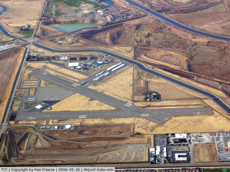
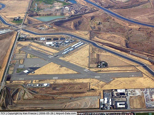
Tracy Municipal Airport covers an area of 310 acres (125 ha) which contains two asphalt paved runways, 7/25 & 12/30, both measuring 4,000 x 100 ft (1,220 x 30 m).
For the 12-month period ending July 17, 2005, the airport had 60,000 aircraft operations, an average of 164 per day: 99% general aviation and 1% air taxi. There are 122 aircraft based at this airport: 95% single engine, 3% multi-engine and 2% ultralight.
FBO Information:
SkyView Aviation, LLC Tracy Municipal Airport 5749 South Tracy Boulevard. Tracy, CA
SkyView Aviation offers a complete line of aviation services including airframe and powerplant repairs, flight instruction, aircraft rentals and sales, charter flight assistance, as well as Light Sport Aircraft training, rentals, and sales.
The above content comes from Wikipedia and is published under free licenses – click here to read more.
|
 |
(Click on the photo to enlarge) |
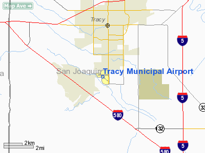
Location
& QuickFacts
|
FAA
Information Effective: |
2006-09-28 |
|
Airport
Identifier: |
TCY |
|
Longitude/Latitude: |
121-26-29.8000W/37-41-20.4000N
-121.441611/37.689000 (Estimated) |
|
Elevation: |
193 ft / 58.83 m (Surveyed) |
|
Land: |
310 acres |
|
From
nearest city: |
3 nautical miles SW of Tracy, CA |
|
Location: |
San Joaquin County, CA |
|
Magnetic Variation: |
15E (2000) |
Owner
& Manager
|
Ownership: |
Publicly owned |
|
Owner: |
City Of Tracy |
|
Address: |
400 East 10th Street
Tracy, CA 95376 |
|
Phone
number: |
209-831-4330 |
|
Manager: |
Rod Buchanan
CITY OF TRACY COMMUNITY SERVICES SUPERVISOR, AIRPORT AND
TRANSIT MANAGEMENT |
|
Address: |
400 East 10th
Tracy, CA 94501 |
|
Phone number: |
209-831-4330
FAX: (209) 831-4212. |
Airport
Operations and Facilities
|
Airport
Use: |
Open to public |
|
Wind
indicator: |
Yes |
|
Segmented
Circle: |
Yes |
|
Control
Tower: |
No |
|
Attendance
Schedule: |
MAY-SEP/ALL/0800-2000,OCT-APR/ALL/0800-1700 |
|
Lighting
Schedule: |
DUSK-DAWN
ACTVT MIRL RY 07/25 AND RY 11/29 - CTAF. |
|
Beacon
Color: |
Clear-Green (lighted land airport) |
|
Landing
fee charge: |
No |
|
Sectional
chart: |
San Francisco |
|
Region: |
AWP - Western-Pacific |
|
Traffic
Pattern Alt: |
800 ft |
|
Boundary
ARTCC: |
ZOA - Oakland |
|
Tie-in
FSS: |
RIU - Rancho Murieta |
|
FSS
on Airport: |
No |
|
FSS
Phone: |
916-354-0161 |
|
FSS
Toll Free: |
1-800-WX-BRIEF |
|
NOTAMs
Facility: |
TCY (NOTAM-d service avaliable) |
|
Federal
Agreements: |
NGRY |
Airport
Communications
|
CTAF: |
122.800 |
|
Unicom: |
122.800 |
Airport
Services
|
Fuel
available: |
100LL80 A |
|
Airframe
Repair: |
MINOR |
|
Power
Plant Repair: |
MINOR |
|
Bottled
Oxygen: |
NONE |
|
Bulk
Oxygen: |
NONE |
|
Runway Information
Runway 07/25
|
Dimension: |
4005 x 100 ft / 1220.7 x 30.5 m |
|
Surface: |
ASPH, Fair Condition |
|
Weight
Limit: |
Single wheel: 50000 lbs.
Dual wheel: 70000 lbs.
Dual tandem wheel: 120000 lbs. |
|
Edge
Lights: |
Medium |
|
|
Runway 07 |
Runway 25 |
|
Longitude: |
121-26-57.1797W |
121-26-07.3591W |
|
Latitude: |
37-41-25.7204N |
37-41-26.0111N |
|
Elevation: |
193.00 ft |
171.00 ft |
|
Alignment: |
90 |
127 |
|
Traffic
Pattern: |
Left |
Left |
|
Markings: |
Basic, Fair Condition |
Basic, Fair Condition |
|
Crossing
Height: |
20.00 ft |
21.00 ft |
|
Displaced
threshold: |
271.00 ft |
295.00 ft |
|
VASI: |
2-box on left side
VASI RY 07 OTS INDEFLY. |
2-box on right side
VASI RY 25 OTS INDEFLY. |
|
Visual
Glide Angle: |
3.40� |
3.00� |
|
Runway
End Identifier: |
No |
No |
|
Centerline
Lights: |
No |
No |
|
Touchdown
Lights: |
No |
No |
|
Obstruction: |
8 ft fence, 350.0 ft from runway, 140 ft right
of centerline, 18:1 slope to clear |
15 ft road, 500.0 ft from runway, 20:1 slope to
clear |
|
Runway 12/30
|
Dimension: |
4001 x 100 ft / 1219.5 x 30.5 m |
|
Surface: |
ASPH, Fair Condition |
|
Weight
Limit: |
Single wheel: 50000 lbs.
Dual wheel: 70000 lbs.
Dual tandem wheel: 120000 lbs. |
|
Edge
Lights: |
Medium |
|
|
Runway 12 |
Runway 30 |
|
Longitude: |
121-26-45.9326W |
121-26-08.6723W |
|
Latitude: |
37-41-28.1176N |
37-41-01.8916N |
|
Elevation: |
180.00 ft |
193.00 ft |
|
Alignment: |
127 |
127 |
|
Traffic
Pattern: |
Left |
Left |
|
Markings: |
Basic, Fair Condition |
Basic, Fair Condition |
|
Crossing
Height: |
0.00 ft |
30.00 ft |
|
Displaced
threshold: |
0.00 ft |
261.00 ft |
|
VASI: |
|
4-box on left side |
|
Visual
Glide Angle: |
0.00� |
3.00� |
|
Runway
End Identifier: |
No |
No |
|
Centerline
Lights: |
No |
No |
|
Touchdown
Lights: |
No |
No |
|
Obstruction: |
25 ft bldg, 1100.0 ft from runway, 36:1 slope
to clear |
15 ft road, 510.0 ft from runway, 280 ft right
of centerline, 20:1 slope to clear |
|
Radio Navigation
Aids
|
ID |
Type |
Name |
Ch |
Freq |
Var |
Dist |
|
TCY |
NDB |
Tracy |
|
203.00 |
15E |
0.2 nm |
|
LV |
NDB |
Reiga |
|
374.00 |
16E |
11.5 nm |
|
PDG |
NDB |
Pajar |
|
327.00 |
17E |
49.8 nm |
|
NUQ |
TACAN |
Moffett |
123X |
|
17E |
33.2 nm |
|
SUU |
TACAN |
Travis |
113X |
|
17E |
41.1 nm |
|
TZZ |
VOR |
Travis |
|
116.40 |
17E |
43.1 nm |
|
MOD |
VOR/DME |
Modesto |
093X |
114.60 |
17E |
23.3 nm |
|
SJC |
VOR/DME |
San Jose |
088X |
114.10 |
16E |
30.5 nm |
|
CCR |
VOR/DME |
Concord |
117X |
117.00 |
17E |
35.7 nm |
|
SFO |
VOR/DME |
San Francisco |
105X |
115.80 |
17E |
44.6 nm |
|
ECA |
VORTAC |
Manteca |
107X |
116.00 |
17E |
15.5 nm |
|
LIN |
VORTAC |
Linden |
095X |
114.80 |
17E |
31.1 nm |
|
OAK |
VORTAC |
Oakland |
115X |
116.80 |
17E |
37.3 nm |
|
OSI |
VORTAC |
Woodside |
086X |
113.90 |
17E |
43.8 nm |
|
SAC |
VORTAC |
Sacramento |
099X |
115.20 |
17E |
45.7 nm |
|
SFO |
VOT |
San Francisco Intl |
|
111.00 |
|
44.6 nm |
|
SAC |
VOT |
Sacramento Executive |
|
111.40 |
|
49.6 nm |
Remarks
- BALLOON;
GYROCOPTER; ULTRALIGHT & PARAPLANE ACTIVITY ON WEEKENDS.
- WEATHER
ROBOT PHONE (209) 835-6098.
- AEROBATIC
AREA ADJ/WI 1 SMR FROM 500 AGL - 3000 MSL SR-SS.
- 100
FT CRANE LOCATED 600 FT SW OF THE APCH END RY 30.
Based Aircraft
|
Aircraft
based on field: |
122 |
|
Single
Engine Airplanes: |
116 |
|
Multi
Engine Airplanes: |
4 |
|
Ultralights: |
2 |
Operational Statistics
|
Aircraft
Operations: |
165/Day |
|
Air Taxi: |
0.5% |
|
General
Aviation Local: |
34.1% |
|
General
Aviation Itinerant: |
65.4% |
Tracy Municipal Airport
Address:
San Joaquin County, CA
Tel:
209-831-433
Images
and information placed above are from
http://www.airport-data.com/airport/TCY/
We
thank them for the data!
| General
Info |
| Country |
United
States |
| State |
CALIFORNIA
|
| FAA ID |
TCY
|
| Latitude |
37-41-20.788N
|
| Longitude |
121-26-30.542W
|
| Elevation |
193 feet
|
| Near City |
TRACY
|
We don't guarantee the information is fresh and accurate. The data may
be wrong or outdated.
For more up-to-date information please refer to other sources.
|
|