 |
|
Location
& QuickFacts
|
FAA
Information Effective: |
2006-09-28 |
|
Airport
Identifier: |
CA38 |
|
Longitude/Latitude: |
120-26-18.7590W/39-39-04.6480N
-120.438544/39.651291 (Estimated) |
|
Elevation: |
4986 ft / 1519.73 m (Estimated) |
|
Land: |
54 acres |
|
From
nearest city: |
1 nautical miles S of Calpine, CA |
|
Location: |
Sierra County, CA |
|
Magnetic Variation: |
16E (1985) |
Owner
& Manager
|
Ownership: |
Privately owned |
|
Owner: |
Earl Jinnette |
|
Address: |
Po Box 4
Calpine, CA 96124 |
|
Phone number: |
530-994-3537 |
|
Manager: |
Earl Jinnette |
|
Address: |
Po Box 4
Calpine, CA 96124 |
|
Phone number: |
530-994-3537 |
Airport
Operations and Facilities
|
Airport
Use: |
Private |
|
Wind
indicator: |
Yes |
|
Segmented
Circle: |
No |
|
Control
Tower: |
No |
|
Attendance
Schedule: |
ALL/ALL/ALL |
|
Landing
fee charge: |
No |
|
Sectional
chart: |
San Francisco |
|
Region: |
AWP - Western-Pacific |
|
Boundary
ARTCC: |
ZOA - Oakland |
|
Tie-in FSS: |
RNO - Reno |
|
FSS on Airport: |
No |
|
FSS Phone: |
775-858-1300 |
|
FSS Toll Free: |
1-800-WX-BRIEF |
Airport
Services
|
Airframe
Repair: |
NONE |
|
Power
Plant Repair: |
NONE |
|
Runway Information
Runway 02/20
|
Dimension: |
1800 x 100 ft / 548.6 x 30.5 m |
|
Surface: |
DIRT, |
|
|
Runway 02 |
Runway 20 |
|
Traffic
Pattern: |
Left |
Left |
|
Radio Navigation
Aids
|
ID |
Type |
Name |
Ch |
Freq |
Var |
Dist |
|
SWR |
VOR/DME |
Squaw Valley |
079X |
113.20 |
16E |
29.4 nm |
|
AHC |
VOR/DME |
Amedee |
027X |
109.00 |
17E |
39.3 nm |
|
FMG |
VORTAC |
Mustang |
126X |
117.90 |
16E |
37.0 nm |
Remarks
- SOUTH
END OF RWY 20 IS BORDER OF TAHOE NAT'L FOREST.
- NATURAL
CLEARING OF TREES FOR APPROXIMATELY 1200 FEET.
- MTN
TERRAIN RISES TO APPROXIMATELY 7000' BEGINNING 3000' SOUTH OF NATIONAL
FOREST BORDER.
- FILED
FOR RECORD PURPOSES ONLY, PERSONAL USE-VFR CONDS ONLY.
Based Aircraft
|
Aircraft
based on field: |
1 |
|
Single
Engine Airplanes: |
1 |
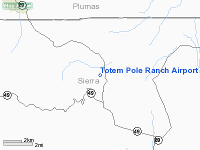
Totem Pole Ranch Airport
Address:
Sierra County, CA
Tel:
530-994-3537
Images
and information placed above are from
http://www.airport-data.com/airport/CA38/
We
thank them for the data!
| General
Info |
| Country |
United
States |
| State |
CALIFORNIA
|
| FAA ID |
CA38
|
| Latitude |
39-39-04.648N
|
| Longitude |
120-26-18.759W
|
| Elevation |
4986 feet
|
| Near City |
CALPINE
|
We don't guarantee the information is fresh and accurate. The data may
be wrong or outdated.
For more up-to-date information please refer to other sources.
|
|


