 |
|
|
|
Location
& QuickFacts
|
FAA
Information Effective: |
2006-09-28 |
|
Airport
Identifier: |
53CN |
|
Longitude/Latitude: |
121-55-03.8910W/39-04-29.6180N
-121.917748/39.074894 (Estimated) |
|
Elevation: |
54 ft / 16.46 m (Estimated) |
|
Land: |
0 acres |
|
From
nearest city: |
2 nautical miles NW of Grimes, CA |
|
Location: |
Colusa County, CA |
|
Magnetic Variation: |
16E (1985) |
Owner
& Manager
|
Ownership: |
Privately owned |
|
Owner: |
B. Charter |
|
Address: |
Po Box 10
Grimes, CA 95950 |
|
Phone number: |
916-437-2225 |
|
Manager: |
Bob Williams |
|
Address: |
Po Box 10
Grimes, CA 95950 |
|
Phone number: |
916-437-2319 |
Airport
Operations and Facilities
|
Airport Use: |
Private |
|
Wind indicator: |
Yes |
|
Segmented Circle: |
No |
|
Control Tower: |
No |
|
Attendance Schedule: |
ALL/MON-SAT/0800-1700 |
|
Landing fee charge: |
No |
|
Sectional chart: |
San Francisco |
|
Region: |
AWP - Western-Pacific |
|
Boundary ARTCC: |
ZOA - Oakland |
|
Tie-in FSS: |
RIU - Rancho Murieta |
|
FSS on Airport: |
No |
|
FSS Phone: |
916-354-0161 |
|
FSS Toll Free: |
1-800-WX-BRIEF |
Airport
Services
|
Airframe
Repair: |
NONE |
|
Power
Plant Repair: |
NONE |
|
Runway
Information
Runway NW/SE
|
Dimension: |
1800 x 60 ft / 548.6 x 18.3 m |
|
Surface: |
ASPH, |
|
|
Runway NW |
Runway SE |
|
Traffic
Pattern: |
Left |
Left |
|
Radio Navigation
Aids
|
ID |
Type |
Name |
Ch |
Freq |
Var |
Dist |
|
MY |
NDB |
Halow |
|
222.00 |
16E |
15.4 nm |
|
OVE |
NDB |
Oroville |
|
212.00 |
16E |
28.7 nm |
|
LOP |
NDB |
Lampson |
|
217.00 |
16E |
45.3 nm |
|
BAB |
TACAN |
Beale |
023X |
|
16E |
22.5 nm |
|
SUU |
TACAN |
Travis |
113X |
|
17E |
49.9 nm |
|
TZZ |
VOR |
Travis |
|
116.40 |
17E |
44.2 nm |
|
MYV |
VOR/DME |
Marysville |
045X |
110.80 |
16E |
16.1 nm |
|
MCC |
VOR/DME |
Mc Clellan |
029X |
109.20 |
17E |
34.3 nm |
|
CIC |
VOR/DME |
Chico |
035X |
109.80 |
16E |
43.1 nm |
|
ILA |
VORTAC |
Williams |
091X |
114.40 |
18E |
5.1 nm |
|
MXW |
VORTAC |
Maxwell |
037X |
110.00 |
18E |
20.3 nm |
|
SAC |
VORTAC |
Sacramento |
099X |
115.20 |
17E |
41.6 nm |
|
SMF |
VOT |
Sacramento Metropolitan |
|
111.40 |
|
27.7 nm |
|
SAC |
VOT |
Sacramento Executive |
|
111.40 |
|
39.0 nm |
Remarks
- HANGAR
& LGTD TWR NE CORNER & POWER LINE E SIDE OF RWY.
- ESTABD
PRIOR TO 15 MAY 1959.
Based Aircraft
|
Aircraft
based on field: |
7 |
|
Single
Engine Airplanes: |
7 |
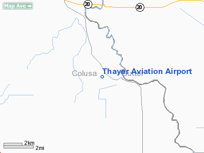
Thayer Aviation Airport
Address:
Colusa County, CA
Tel:
916-437-2225, 916-437-2319
Images
and information placed above are from
http://www.airport-data.com/airport/53CN/
We
thank them for the data!
| General
Info |
| Country |
United
States |
| State |
CALIFORNIA
|
| FAA ID |
53CN
|
| Latitude |
39-04-29.618N
|
| Longitude |
121-55-03.891W
|
| Elevation |
54 feet
|
| Near City |
GRIMES
|
We don't guarantee the information is fresh and accurate. The data may
be wrong or outdated.
For more up-to-date information please refer to other sources.
|
|


