 |
|
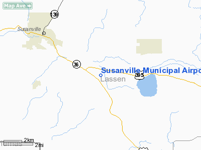
Susanville Municipal Airport |
| Susanville Municipal Airport |
| IATA: SVE – ICAO: KSVE – FAA LID: SVE |
| Summary |
| Airport type |
Public |
| Operator |
City of Susanville |
| Location |
Susanville, California |
| Elevation AMSL |
4,149 ft / 1,264.6 m |
| Coordinates |
40°22′32″N 120°34′22″W / 40.37556°N 120.57278°W / 40.37556; -120.57278Coordinates: 40°22′32″N 120°34′22″W / 40.37556°N 120.57278°W / 40.37556; -120.57278 |
| Runways |
| Direction |
Length |
Surface |
| ft |
m |
| 11/29 |
4,049 |
1,234 |
Asphalt |
| 7/25 |
2,179 |
664 |
Soil |
| Helipads |
| Number |
Length |
Surface |
| ft |
m |
| H1 |
120 |
37 |
Asphalt |
| H2 |
65 |
20 |
Asphalt |
Susanville Municipal Airport (IATA: SVE, ICAO: KSVE, FAA LID: SVE) is a public airport located five miles (8 km) southeast of the central business district (CBD) of Susanville, a city in Lassen County, California, USA. This general aviation airport, covering an area of 130 acres (53 ha), has two runways and two helipads.
The above content comes from Wikipedia and is published under free licenses – click here to read more.
Location
& QuickFacts
|
FAA
Information Effective: |
2006-09-28 |
|
Airport
Identifier: |
SVE |
|
Longitude/Latitude: |
120-34-21.7000W/40-22-32.5000N
-120.572694/40.375694 (Estimated) |
|
Elevation: |
4149 ft / 1264.62 m (Surveyed) |
|
Land: |
130 acres |
|
From
nearest city: |
5 nautical miles SE of Susanville, CA |
|
Location: |
Lassen County, CA |
|
Magnetic Variation: |
17E (1985) |
Owner
& Manager
|
Ownership: |
Publicly owned |
|
Owner: |
City Of Susanville |
|
Address: |
66 N. Lassen St.
Susanville, CA 96130 |
|
Phone
number: |
530-257-1050 |
|
Manager: |
Steve Datama
PUBLIC WORKS DIRECTOR, OFFICE IN SUSANVILLE. |
|
Address: |
471-920 Johnstonville Road #10
Susanville, CA 96130 |
|
Phone number: |
530-257-2030 |
Airport
Operations and Facilities
|
Airport
Use: |
Open to public |
|
Wind
indicator: |
Yes |
|
Segmented
Circle: |
Yes |
|
Control
Tower: |
No |
|
Attendance
Schedule: |
ALL/ALL/0800-1700 |
|
Lighting
Schedule: |
DUSK-DAWN
ACTVT MIRL RY 11/29 - CTAF. |
|
Beacon
Color: |
Clear-Green (lighted land airport) |
|
Landing
fee charge: |
No |
|
Sectional
chart: |
Klamath Falls |
|
Region: |
AWP - Western-Pacific |
|
Traffic
Pattern Alt: |
800 ft |
|
Boundary
ARTCC: |
ZOA - Oakland |
|
Tie-in
FSS: |
RNO - Reno |
|
FSS
on Airport: |
No |
|
FSS
Phone: |
775-858-1300 |
|
FSS
Toll Free: |
1-800-WX-BRIEF |
|
NOTAMs
Facility: |
SVE (NOTAM-d service avaliable) |
|
Federal Agreements: |
NGY |
Airport
Communications
|
CTAF: |
122.800 |
|
Unicom: |
122.800 |
Airport
Services
|
Fuel
available: |
100LL80 A |
|
Airframe
Repair: |
MAJOR |
|
Power
Plant Repair: |
MAJOR |
|
Bottled
Oxygen: |
NONE |
|
Bulk
Oxygen: |
NONE |
|
Runway Information
Runway 07/25
|
Dimension: |
2179 x 60 ft / 664.2 x 18.3 m |
|
Surface: |
DIRT, Fair Condition |
|
|
Runway 07 |
Runway 25 |
|
Longitude: |
120-34-41.5516W |
120-34-13.4007W |
|
Latitude: |
40-22-28.3281N |
40-22-28.5276N |
|
Elevation: |
4149.00 ft |
4130.00 ft |
|
Alignment: |
89 |
127 |
|
Traffic
Pattern: |
Left |
Left |
|
Markings: |
None, |
None, |
|
Runway
End Identifier: |
No |
No |
|
Centerline
Lights: |
No |
No |
|
Touchdown
Lights: |
No |
No |
|
Obstruction: |
5 ft fence, 60.0 ft from runway, 12:1 slope
to clear |
, 50:1 slope to clear |
|
Runway 11/29
|
Dimension: |
4049 x 75 ft / 1234.1 x 22.9 m |
|
Surface: |
ASPH, Fair Condition |
|
Surface
Treatment: |
Saw-cut or plastic Grooved |
|
Weight
Limit: |
Single wheel: 15000 lbs.
LTD TO 12000 LBS BY AMGR. |
|
Edge
Lights: |
Medium |
|
|
Runway 11 |
Runway 29 |
|
Longitude: |
120-34-38.9366W |
120-33-58.2793W |
|
Latitude: |
40-22-47.2505N |
40-22-22.0849N |
|
Elevation: |
4147.00 ft |
4122.00 ft |
|
Alignment: |
127 |
127 |
|
Traffic
Pattern: |
Left |
Right |
|
Markings: |
Basic, Fair Condition |
Basic, Fair Condition |
|
Crossing
Height: |
0.00
ft |
25.00 ft |
|
VASI: |
|
2-box on left side |
|
Visual
Glide Angle: |
0.00� |
3.00� |
|
Runway
End Identifier: |
No |
No |
|
Centerline
Lights: |
No |
No |
|
Touchdown
Lights: |
No |
No |
|
Obstruction: |
70 ft trees, 1650.0 ft from runway, 125 ft
right of centerline, 20:1 slope to clear |
, 50:1 slope to clear |
|
Helipad H1
|
Dimension: |
120 x 120 ft / 36.6 x 36.6 m |
|
Surface: |
ASPH, Good Condition |
|
|
Runway H1 |
Runway H2 |
|
Traffic
Pattern: |
Left |
Left |
|
Helipad H2
|
Dimension: |
65 x 65 ft / 19.8 x 19.8 m |
|
Surface: |
ASPH, Good Condition |
|
|
Runway |
Runway |
|
Traffic
Pattern: |
Left |
Left |
|
Radio Navigation
Aids
|
ID |
Type |
Name |
Ch |
Freq |
Var |
Dist |
|
AHC |
VOR/DME |
Amedee |
027X |
109.00 |
17E |
20.3 nm |
Remarks
- TAXIWAY
D OBSTRUCED BY A LIGHTED HELIPORT H2
Based Aircraft
|
Aircraft
based on field: |
54 |
|
Single
Engine Airplanes: |
45 |
|
Multi
Engine Airplanes: |
5 |
|
Helicopters: |
1 |
|
Ultralights: |
3 |
Operational Statistics
|
Aircraft
Operations: |
202/Week |
|
Air Taxi: |
7.6% |
|
General
Aviation Local: |
49.0% |
|
General
Aviation Itinerant: |
42.9% |
|
Military: |
0.5% |
Susanville Municipal Airport
Address:
Lassen County, CA
Tel:
530-257-1050,
530-257-2030
Images
and information placed above are from
http://www.airport-data.com/airport/SVE/
We
thank them for the data!
| General
Info |
| Country |
United
States |
| State |
CALIFORNIA
|
| FAA ID |
SVE
|
| Latitude |
40-22-36.628N
|
| Longitude |
120-34-22.812W
|
| Elevation |
4148 feet
|
| Near City |
SUSANVILLE
|
We don't guarantee the information is fresh and accurate. The data may
be wrong or outdated.
For more up-to-date information please refer to other sources.
|
|


