|
|
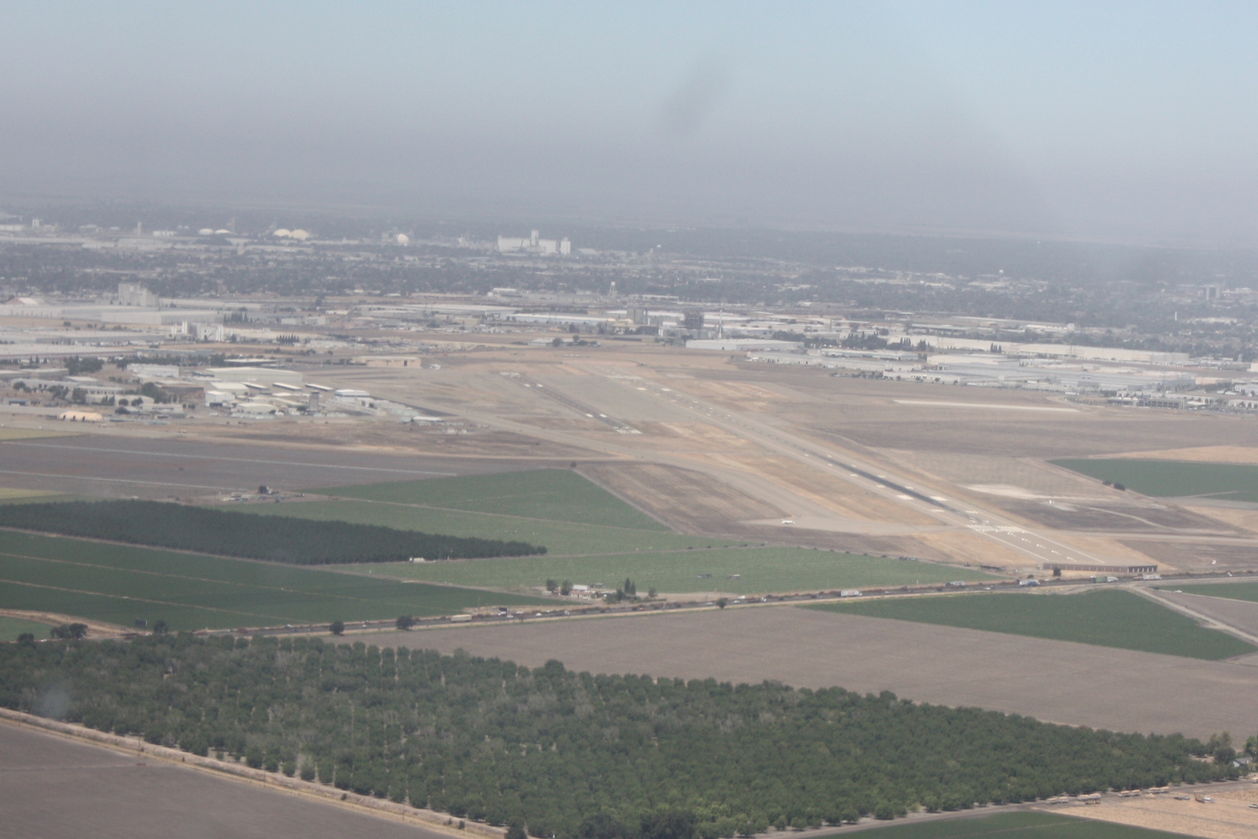
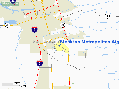
Stockton Metropolitan Airport |
| Stockton Metropolitan Airport |
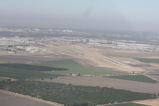 |
| Stockton Metro Airport |
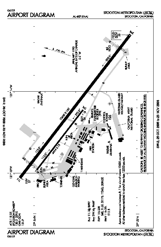 |
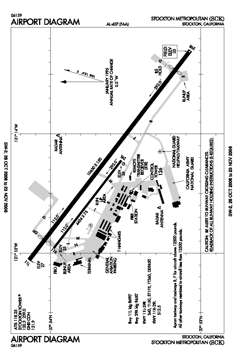
| KSCK airport diagram |
| IATA: SCK – ICAO: KSCK – FAA LID: SCK |
| Summary |
| Airport type |
Public |
| Operator |
County of San Joaquin |
| Location |
San Joaquin County, near Stockton, California |
| Elevation AMSL |
33 ft / 10.1 m |
| Coordinates |
37°53′39″N 121°14′18″W / 37.89417°N 121.23833°W / 37.89417; -121.23833Coordinates: 37°53′39″N 121°14′18″W / 37.89417°N 121.23833°W / 37.89417; -121.23833 |
| Runways |
| Direction |
Length |
Surface |
| ft |
m |
| 11L/29R |
10,650 |
3,246 |
Asphalt |
| 11R/29L |
4,454 |
1,358 |
Asphalt |
| Helipads |
| Number |
Length |
Surface |
| ft |
m |
| H1 |
70 |
21 |
Concrete |
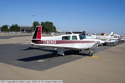
Stockton Airport, 16 August 1998 Stockton Metropolitan Airport (IATA: SCK, ICAO: KSCK, FAA LID: SCK) is a public airport located three miles (5 km) southeast of the central business district (CBD) of Stockton, a city in San Joaquin County, California, US History
The airport was once a major hub for air-travel in the San Joaquin Valley, but like so many other American airports of similar size, deregulation eventually eliminated commercial service to the airport for many years. As for commercial air, America West had left the airport and the terminal empty in 2003.
Allegiant's success at the airport could help draw other carriers to the airport. Load factors for Allegiant are about 90 percent, well above the necessary level to maintain profitable service.
Airport director Susan Palmeri hopes to give area residents more options for flights from the airport. Ms. Palmeri has been hoping to secure airline service to many different destinations and major hub airports and increase cargo opportunities.
In June 2006, Allegiant Air began flying round trips to Las Vegas and on July 1, 2010, Allegiant Air began service to Long Beach.
Flights to Mexico
Aeromexico had expressed interest to start service at the airport in 2006 and provide flights to Guadalajara and Morelia. However, the airport was unable to secure a customs facility. Federal officials saw no need for such facility as they already existed at nearby airports in Sacramento, Oakland, San Francisco and San Jose.
Local officials later filed an appeal and Congressman Richard Pombo also persuaded officials to approve of a facility. Federal officials then reconsidered and approved the plans for the facility. Despite the Federal approval, San Joaquin County Supervisors decided against financing the project. The supervisors claimed that the taxpayers dollars would be better spent elsewhere.
Airlines and destinations
| Airlines |
Destinations |
| Allegiant Air |
Las Vegas, Long Beach |
Facilities
Stockton Metropolitan Airport covers 1,552 acres and has two runways and one helipad:
- Runway 11L/29R: 10,650 x 150 ft. (3,246 x 46 m), Surface: Asphalt
- Runway 11R/29L: 4,454 x 75 ft. (1,358 x 23 m), Surface: Asphalt
- Helipad H1: 70 x 70 ft. (21 x 21 m), Surface: Concrete
World War II
Stockton Field was dedicated on 11 January 1941 as an United States Army Air Forces Advanced Flying School. Thousands of airmen were trained here before and during WWII. Flying training was performed with Fairchild PT-19s as the primary trainer. Also had several PT-17 Stearmans and a few P-40 Warhawks assigned.
Late in the war the field was taken over by the Military Air Transport Service and was used as a hub for war material transportation.
The above content comes from Wikipedia and is published under free licenses – click here to read more.
|
 |
(Click on the photo to enlarge) |
Location
& QuickFacts
|
FAA
Information Effective: |
2006-09-28 |
|
Airport
Identifier: |
SCK |
|
Longitude/Latitude: |
121-14-17.9000W/37-53-39.0000N
-121.238306/37.894167 (Estimated) |
|
Elevation: |
33 ft / 10.06 m (Surveyed) |
|
Land: |
1552 acres |
|
From
nearest city: |
3 nautical miles SE of Stockton, CA |
|
Location: |
San Joaquin County, CA |
|
Magnetic Variation: |
17E (1985) |
Owner
& Manager
|
Ownership: |
Publicly owned |
|
Owner: |
County Of San Joaquin |
|
Address: |
5000 S Airport Way
Stockton, CA 95206 |
|
Phone
number: |
209-468-4700 |
|
Manager: |
Barry Rondinella |
|
Address: |
5000 S. Airport Way, Rm 202
Stockton, CA 95206 |
|
Phone number: |
209-468-4700 |
Airport
Operations and Facilities
|
Airport
Use: |
Open to public |
|
Wind
indicator: |
Yes |
|
Segmented
Circle: |
Yes |
|
Control
Tower: |
Yes |
|
Attendance
Schedule: |
ALL/ALL/ALL |
|
Lighting
Schedule: |
DUSK-DAWN
ACTVT HIRL RY 11L/29R, PAPI RY 11L AND RY 29R, MALSR RY
29R - CTAF. |
|
Beacon
Color: |
Clear-Green (lighted land airport) |
|
Landing
fee charge: |
Yes
LNDG FEE FOR ACFT OVER 12500 LBS. |
|
Sectional
chart: |
San Francisco |
|
Region: |
AWP - Western-Pacific |
|
Boundary
ARTCC: |
ZOA - Oakland |
|
Tie-in
FSS: |
RIU - Rancho Murieta |
|
FSS
on Airport: |
No |
|
FSS
Phone: |
916-354-0161 |
|
FSS
Toll Free: |
1-800-WX-BRIEF |
|
NOTAMs
Facility: |
SCK (NOTAM-d service avaliable) |
|
Certification
type/date: |
I BS 5/1973
CLSD TO UNSCHEDULED AIR CARRIER OPNS WITH MORE THAN 30 PSGR
SEATS EXCP ONE HR PPR CALL AMGR (209) 468-4700 OR 4722;
AFTER HRS CALL (209) 478-9034. |
|
Federal Agreements: |
NGPY |
Airport
Communications
|
CTAF: |
120.300 |
|
Unicom: |
122.950 |
Airport
Services
|
Fuel
available: |
100 100LLA
FUEL & SVC 0500-2100; OTHER TIMES CALL (209) 468-4722
- SVC CHARGE. |
|
Airframe
Repair: |
MAJOR |
|
Power
Plant Repair: |
MAJOR |
|
Bottled
Oxygen: |
HIGH |
|
Bulk
Oxygen: |
HIGH |
|
Runway Information
Runway 11L/29R
|
Dimension: |
10650 x 150 ft / 3246.1 x 45.7 m |
|
Surface: |
ASPH, Good Condition |
|
Surface
Treatment: |
Saw-cut or plastic Grooved |
|
Weight
Limit: |
Single wheel: 40000 lbs.
Dual wheel: 150000 lbs.
Dual tandem wheel: 360000 lbs.
Dual dual tandem wheel: 650000 lbs. |
|
Edge
Lights: |
High |
|
|
Runway 11L |
Runway 29R |
|
Longitude: |
121-15-03.1976W |
121-13-17.9130W |
|
Latitude: |
37-54-08.4290N |
37-53-04.2134N |
|
Elevation: |
26.00 ft |
33.00 ft |
|
Alignment: |
127 |
127 |
|
ILS
Type: |
|
ILS |
|
Traffic
Pattern: |
Left |
Right |
|
Markings: |
Precision instrument, Good Condition |
Precision instrument, Good Condition |
|
Crossing
Height: |
65.00 ft |
62.00 ft |
|
Displaced
threshold: |
990.00 ft |
1000.00 ft |
|
VASI: |
4-light PAPI on left side |
4-light PAPI on left side |
|
Visual
Glide Angle: |
3.00� |
2.94� |
|
Approach
lights: |
|
MALSR |
|
Runway
End Identifier: |
No |
No |
|
Centerline
Lights: |
No |
No |
|
Touchdown
Lights: |
No |
No |
|
Decleard
distances: |
Take off run available 9600.00 ft
Take off distance available 10600.00 ft
Actual stop distance available 9690.00 ft
Landing distance available 8690.00 ft |
Take off run available 10037.00 ft
Take off distance available 11037.00 ft
Actual stop distance available 9701.00 ft
Landing distance available 8701.00 ft |
|
Runway 11R/29L
|
Dimension: |
4454 x 75 ft / 1357.6 x 22.9 m |
|
Surface: |
ASPH, Good Condition |
|
Weight
Limit: |
Single wheel: 12500 lbs. |
|
|
Runway 11R |
Runway 29L |
|
Longitude: |
121-14-57.4818W |
121-14-13.4411W |
|
Latitude: |
37-53-58.7050N |
37-53-31.8555N |
|
Elevation: |
25.00 ft |
26.00 ft |
|
Alignment: |
127 |
127 |
|
Traffic
Pattern: |
Right |
Left |
|
Markings: |
Basic, Good Condition |
Basic, Good Condition |
|
Runway
End Identifier: |
No |
No |
|
Centerline
Lights: |
No |
No |
|
Touchdown
Lights: |
No |
No |
|
Helipad H1
|
Dimension: |
70 x 70 ft / 21.3 x 21.3 m |
|
Surface: |
CONC, Good Condition |
|
Weight
Limit: |
Single wheel: 45000 lbs.
Dual wheel: 55000 lbs. |
|
|
Runway H1 |
Runway |
|
Traffic
Pattern: |
Left |
Left |
|
Radio Navigation
Aids
|
ID |
Type |
Name |
Ch |
Freq |
Var |
Dist |
|
TCY |
NDB |
Tracy |
|
203.00 |
15E |
15.6 nm |
|
LV |
NDB |
Reiga |
|
374.00 |
16E |
24.4 nm |
|
SUU |
TACAN |
Travis |
113X |
|
17E |
39.6 nm |
|
NUQ |
TACAN |
Moffett |
123X |
|
17E |
47.9 nm |
|
TZZ |
VOR |
Travis |
|
116.40 |
17E |
38.3 nm |
|
MOD |
VOR/DME |
Modesto |
093X |
114.60 |
17E |
20.9 nm |
|
CCR |
VOR/DME |
Concord |
117X |
117.00 |
17E |
39.3 nm |
|
SJC |
VOR/DME |
San Jose |
088X |
114.10 |
16E |
45.9 nm |
|
MCC |
VOR/DME |
Mc Clellan |
029X |
109.20 |
17E |
47.1 nm |
|
ECA |
VORTAC |
Manteca |
107X |
116.00 |
17E |
4.8 nm |
|
LIN |
VORTAC |
Linden |
095X |
114.80 |
17E |
15.5 nm |
|
SAC |
VORTAC |
Sacramento |
099X |
115.20 |
17E |
36.2 nm |
|
OAK |
VORTAC |
Oakland |
115X |
116.80 |
17E |
47.9 nm |
|
SAC |
VOT |
Sacramento Executive |
|
111.40 |
|
39.2 nm |
Remarks
- SEAGULLS
ON AND IN VCNTY OF ARPT MOSTLY DURING RAINY WEATHER.
- AVOID
OVERFLYING SAN JOAQUIN GENERAL HOSPITAL & THE CITY OF MANTECA.
- ARPT
CLSD TO TGL & PLANNED LOW APCHS FOR TURBOJET ACFT 2200-0700 EXCEPT
BY PPR FM AMGR PART 36 STAGE 3 ACFT.
- PRACTICE
CIRCLING APPROACHES TO RWYS 11L/11R NA FOR ANY TURBINE POWERED ACFT/PROP
DRIVEN ACFT EXCEEDING 12500 LBS EXCP BY PPR FM AMGR.
- MILITARY
USE: ARNG OPR 1500-2330Z++ MON-FRI. DSN 466-5319, C209-983-5319, FAX
5391. PPR REQUIRED. LDTD
TRAN SVC AND MAINT AVBL FOR CH47.
Based Aircraft
|
Aircraft
based on field: |
231 |
|
Single
Engine Airplanes: |
159 |
|
Multi
Engine Airplanes: |
28 |
|
Jet Engine
Airplanes: |
8 |
|
Helicopters: |
8 |
|
Military: |
28 |
Operational Statistics
|
Aircraft
Operations: |
206/Day |
|
Air Carrier: |
0.0% |
|
Air Taxi: |
1.7% |
|
General
Aviation Local: |
18.9% |
|
General
Aviation Itinerant: |
75.1% |
|
Military: |
4.2% |
Stockton Metropolitan Airport
Address:
San Joaquin County, CA
Tel:
209-468-4700
Images
and information placed above are from
http://www.airport-data.com/airport/SCK/
We
thank them for the data!
| General
Info |
| Country |
United
States |
| State |
CALIFORNIA
|
| FAA ID |
SCK
|
| Latitude |
37-53-39.361N
|
| Longitude |
121-14-19.033W
|
| Elevation |
30 feet
|
| Near City |
STOCKTON
|
We don't guarantee the information is fresh and accurate. The data may
be wrong or outdated.
For more up-to-date information please refer to other sources.
|
|