|
 |
|
||||
|
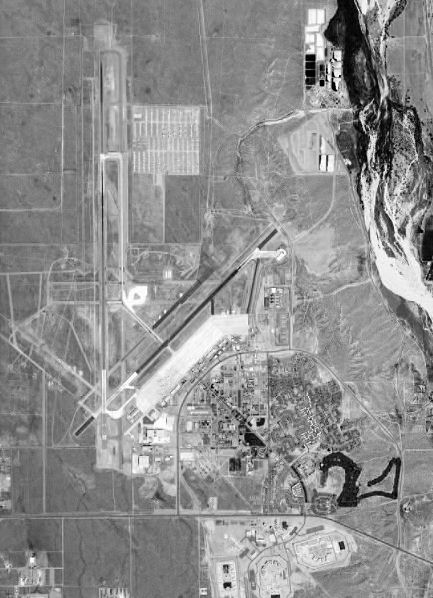
Southern California Logistics Airport (IATA: VCV, ICAO: KVCV), also known as Victorville Airport, is a public airport located in the city of Victorville in San Bernardino County, California, USA approximately 20 miles (32 km) north of San Bernardino. Prior to its civil usage, the facility was known as George Air Force Base, (1941-1992) which was a front-line United States Air Force base. It is home to a the World's Largest Transitional Facility for Commercial Aircraft, Southern California Aviation. FacilitiesSouthern California Logistics Airport covers 2,300 acres (930 ha) and has two runways:
Southern California Logistics Centre, immediately adjacent to SCLA, offers a wide variety of new warehouse and distribution facilities, ranging from 2,000 square feet (190 m) to over 1 Million Square Feet (www.globalaccessvictorville.com) The SCLA MOUT Facility offers urban warfare training, and has served over 15,000 U.S. Military Personnel during the past ten years. Airport overview
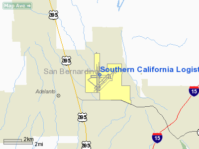
The federal government is responsible for helping the Victor Valley recover from the closure of George Air Force Base in 1992. The conversion of the former George Air Force Base to Southern California Logistics Airport [SCLA] was designed to provide major corporations with logistics needs access to a global intermodal logistics gateway to the Western United States. Located near Interstate 15 in California's Victor Valley, the 5,000-acre (2,000 ha) complete intermodal business complex is approximately 20 miles (32 km) north of downtown San Bernardino, and 23 miles (37 km) north of San Bernardino International Airport. In July 2000 the Department of Commerce awarded the Southern California Logistics Airport the designation of Foreign Trade Zone. The designation was intended to make it much easier for the Victor Valley Economic Development Authority to convince international carriers to use the airport as a base for shipping foreign products to Southern California. During that same period, the Department of Transportation approved a $4.9 million grant for the Southern California Logistics Airport to extend its main runway from 10,050 feet (3,060 m) to 13,050 feet (3,980 m) to accommodate international jet transports. The airport authority required the 3,000 ft (910 m) extension to ensure that cargo planes could depart fully-loaded in summer heat. The longer runway was also required for the efficient use of the facility as the main transportation hub for the 70,000 troops a year traveling to and from the Army National Training Center at Fort Irwin. At 15,059 feet (4,587 m), Southern California Logistics Airport's runway 17/35 is the second longest public-use runway in the United States, surpassed only by that of Denver International Airport's 16,000 foot (4,877 m) runway 16R/34L. The Fiscal Year 2002 military spending bill earmarked $1.3 million to allow the U.S. Army to continue using the Southern California Logistics Airport (SCLA) to transport troops en route to training exercises at Fort Irwin. The airport has proven to be one of the most efficient and safest locations for travel to and from the Army's National Training Center for the 70,000 troops who rotate through each year. Company D of the 158th Aviation Regiment is a general support aviation company that moved in under a five-year contract the Army signed with SCLA and the city of Victorville. The unit is part of the 244th Aviation Brigade of Fort Sheridan, IL. The airport has been used for many Hollywood movies, including Face/Off and Jarhead, and was namechecked (as Victorville) in The War of the Worlds. In late 2006, SCLA became home to Air Tanker 910 which is on contract to the California Department of Forestry (CALFIRE). Tanker 910 is the only wide-body jet currently in fire service and uses SCLA as its re-loading base for fires occurring anywhere in California. On August 9, 2007 DARPA announced that for their 2007 Autonomous Vehicle Competition both the Urban Challenge NQE and final event would take place at the urban military training facility located on the former George Air Force Base. DARPA selected the location because its network of urban roads best simulate the type of terrain American forces operate in when deployed overseas. “The robotic vehicles will conduct simulated military supply missions at the site. This adds many of the elements these vehicles would face in operational environments,” explained Dr. Tether. The above content comes from Wikipedia and is published under free licenses – click here to read more.
Runway InformationRunway 03/21
Runway 17/35
Radio Navigation Aids
Remarks
Based Aircraft
Operational Statistics
Southern California Logistics Airport Address: San Bernardino County, CA Tel: 760-243-1900 Images
and information placed above are from We thank them for the data!
We don't guarantee the information is fresh and accurate. The data may
be wrong or outdated. |
||||||||||||||||||||||||||||||||||||||||||||||||||||||||||||||||||||||||||||||||||||||||||||||||||||||||||||||||||||||||||||||||||||||||||||||||||||||||||||||||||||||||||||||||||||||||||||||||||||||||||||||||||||||||||||||||||||||||||||||||||||||||||||||||||||||||||||||||||||||||||||||||||||||||||||||||||||||||||||||||||||||||||||||||||||||||||

 |
|
Copyright 2004-2024 © by Airports-Worldwide.com, Vyshenskoho st. 36, Lviv 79010, Ukraine Legal Disclaimer |