 |
|
|
|
|
|
Location
& QuickFacts
|
FAA
Information Effective: |
2006-09-28 |
|
Airport
Identifier: |
CA89 |
|
Longitude/Latitude: |
117-18-06.1360W/33-37-48.0810N
-117.301704/33.630023 (Estimated) |
|
Elevation: |
1253 ft / 381.91 m (Estimated) |
|
Land: |
150 acres |
|
From
nearest city: |
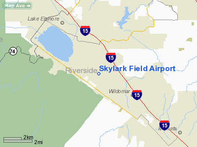
4 nautical miles S of Lake Elsinore, CA |
|
Location: |
Riverside County, CA |
|
Magnetic Variation: |
14E (1985) |
Owner
& Manager
|
Ownership: |
Privately owned |
|
Owner: |
Lake Elsinore Arpt Partnership
KRIS KAKKAR, MANAGING GENERAL PARTNER. |
|
Address: |
1211 North Broadway
Santa Ana, CA 92701-3411 |
|
Phone
number: |
714-834-9200 |
|
Manager: |
Larry Nogles |
|
Address: |
20701 Cereal St
Lake Elsinore, CA 92330 |
|
Phone number: |
951-935-0935 |
Airport
Operations and Facilities
|
Airport
Use: |
Private |
|
Wind
indicator: |
Yes |
|
Segmented
Circle: |
Yes |
|
Control
Tower: |
No |
|
Attendance
Schedule: |
ALL/ALL/DALGT |
|
Landing
fee charge: |
No |
|
Sectional
chart: |
Los Angeles |
|
Region: |
AWP - Western-Pacific |
|
Boundary
ARTCC: |
ZLA - Los Angeles |
|
Tie-in
FSS: |
RAL - Riverside |
|
FSS
on Airport: |
No |
|
FSS
Phone: |
951-351-3020 |
|
FSS
Toll Free: |
1-800-WX-BRIEF |
|
Runway Information
Runway 01/19
|
Dimension: |
1850 x 60 ft / 563.9 x 18.3 m |
|
Surface: |
TURF, |
|
|
Runway 01 |
Runway 19 |
|
Traffic
Pattern: |
Left |
Left |
|
Runway 11L/29R
|
Dimension: |
2800 x 100 ft / 853.4 x 30.5 m |
|
Surface: |
TURF, |
|
|
Runway 11L |
Runway 29R |
|
Traffic
Pattern: |
Left |
Right |
|
Displaced
threshold: |
100.00 ft |
0.00
ft |
|
Runway 11R/29L
|
Dimension: |
2800 x 100 ft / 853.4 x 30.5 m |
|
Surface: |
TURF, |
|
|
Runway 11R |
Runway 29L |
|
Traffic
Pattern: |
Right |
Left |
|
Displaced
threshold: |
1000.00 ft |
0.00
ft |
|
Radio Navigation
Aids
|
ID |
Type |
Name |
Ch |
Freq |
Var |
Dist |
|
SJY |
NDB |
San Jacinto |
|
227.00 |
14E |
18.1 nm |
|
SB |
NDB |
Petis |
|
397.00 |
14E |
25.8 nm |
|
EMT |
NDB |
El Monte |
|
359.00 |
15E |
45.7 nm |
|
CPM |
NDB |
Compton |
|
378.00 |
15E |
49.7 nm |
|
RIV |
TACAN |
March |
077X |
|
14E |
16.7 nm |
|
NFG |
TACAN |
Camp Pendleton |
055X |
|
13E |
21.8 nm |
|
NKX |
TACAN |
Miramar |
033X |
|
15E |
46.3 nm |
|
NKX |
UHF/NDB |
Miramar |
|
352.00 |
15E |
46.1 nm |
|
HDF |
VOR |
Homeland |
|
113.40 |
14E |
10.5 nm |
|
RAL |
VOR |
Riverside |
|
112.40 |
15E |
20.7 nm |
|
ELB |
VOR/DME |
El Toro |
119X |
117.20 |
14E |
21.7 nm |
|
PDZ |
VORTAC |
Paradise |
059X |
112.20 |
15E |
20.7 nm |
|
OCN |
VORTAC |
Oceanside |
100X |
115.30 |
15E |
24.1 nm |
|
POM |
VORTAC |
Pomona |
041X |
110.40 |
15E |
36.2 nm |
|
SLI |
VORTAC |
Seal Beach |
104X |
115.70 |
15E |
38.8 nm |
|
PSP |
VORTAC |
Palm Springs |
102X |
115.50 |
13E |
45.9 nm |
|
JLI |
VORTAC |
Julian |
087X |
114.00 |
15E |
46.4 nm |
|
SNA |
VOT |
Santa Ana |
|
110.00 |
|
28.6 nm |
|
SAN |
VOT |
Mount Soledad |
|
109.00 |
|
47.6 nm |
Remarks
Based Aircraft
|
Aircraft
based on field: |
31 |
|
Single
Engine Airplanes: |
21 |
|
Multi
Engine Airplanes: |
5 |
|
Gliders: |
4 |
|
Ultralights: |
1 |
Skylark Field Airport
Address:
Riverside County, CA
Tel:
714-834-9200,
951-935-0935
Images
and information placed above are from
http://www.airport-data.com/airport/CA89/
We
thank them for the data!
| General
Info |
| Country |
United
States |
| State |
CALIFORNIA
|
| FAA ID |
CA89
|
| Latitude |
33-37-48.081N
|
| Longitude |
117-18-06.136W
|
| Elevation |
1253 feet
|
| Near City |
LAKE ELSINORE
|
We don't guarantee the information is fresh and accurate. The data may
be wrong or outdated.
For more up-to-date information please refer to other sources.
|
|


