 |
|
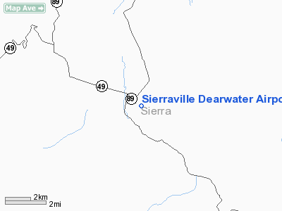
Sierraville Dearwater Airport |
|
|
Location
& QuickFacts
|
FAA
Information Effective: |
2006-09-28 |
|
Airport
Identifier: |
O79 |
|
Longitude/Latitude: |
120-21-15.7450W/39-34-51.6530N
-120.354374/39.581015 (Estimated) |
|
Elevation: |
4984 ft / 1519.12 m (Surveyed) |
|
Land: |
28 acres |
|
From
nearest city: |
1 nautical miles SE of Sierraville, CA |
|
Location: |
Sierra County, CA |
|
Magnetic Variation: |
16E (1985) |
Owner
& Manager
|
Ownership: |
Publicly owned |
|
Owner: |
County Of Sierra |
|
Address: |
Po Box 98
Downieville, CA 95936 |
|
Phone
number: |
916-289-3201 |
|
Manager: |
Tim Beals
SIERRA COUNTY PUBLIC WORKS DIRECTOR. |
|
Address: |
Po Box 98
Downieville, CA 95936 |
|
Phone
number: |
916-289-3201
SIERRA COUNTY PUBLIC WORKS DEPARTMENT, DOWNIEVILLE. |
Airport
Operations and Facilities
|
Airport
Use: |
Open to public |
|
Wind
indicator: |
Yes |
|
Segmented
Circle: |
Yes |
|
Control
Tower: |
No |
|
Attendance
Schedule: |
UNATNDD |
|
Landing
fee charge: |
No |
|
Sectional
chart: |
San Francisco |
|
Region: |
AWP - Western-Pacific |
|
Traffic
Pattern Alt: |
800 ft |
|
Boundary
ARTCC: |
ZOA - Oakland |
|
Tie-in
FSS: |
RNO - Reno |
|
FSS
on Airport: |
No |
|
FSS
Phone: |
775-858-1300 |
|
FSS
Toll Free: |
1-800-WX-BRIEF |
|
NOTAMs
Facility: |
RNO (NOTAM-d service avaliable) |
Airport
Communications
Airport
Services
|
Airframe
Repair: |
NONE |
|
Power
Plant Repair: |
NONE |
|
Bottled
Oxygen: |
NONE |
|
Bulk
Oxygen: |
NONE |
|
Runway Information
Runway 03/21
|
Dimension: |
3260 x 50 ft / 993.6 x 15.2 m |
|
Surface: |
ASPH, Poor Condition
SEVERE CRACKS IN PAVEMENT |
|
Weight
Limit: |
Single wheel: 12000 lbs. |
|
|
Runway 03 |
Runway 21 |
|
Elevation: |
4983.00 ft |
4951.00 ft |
|
Traffic
Pattern: |
Left |
Right |
|
Markings: |
Basic, Fair Condition |
Nonstandard, Fair Condition
RWY 21 DISPLCD RWY MARKINGS PARTIALLY YELLOW |
|
Displaced
threshold: |
0.00
ft |
193.00 ft |
|
Runway
End Identifier: |
No |
No |
|
Centerline
Lights: |
No |
No |
|
Touchdown
Lights: |
No |
No |
|
Obstruction: |
, 50:1 slope to clear |
18 ft road, 200.0 ft from runway, 125 ft left
of centerline
RWY 21 APCH RATIO 10:1 FM DSPLCD THR.
RWY 21 +4' FENCE 0' FM RY END, +18' ROAD O' FM RY END; 125'
L. |
|
Radio Navigation
Aids
|
ID |
Type |
Name |
Ch |
Freq |
Var |
Dist |
|
SWR |
VOR/DME |
Squaw Valley |
079X |
113.20 |
16E |
24.4 nm |
|
AHC |
VOR/DME |
Amedee |
027X |
109.00 |
17E |
42.3 nm |
|
FMG |
VORTAC |
Mustang |
126X |
117.90 |
16E |
32.5 nm |
Based Aircraft
|
Aircraft
based on field: |
1 |
|
Single
Engine Airplanes: |
1 |
Operational Statistics
|
Aircraft
Operations: |
20/Week |
|
General
Aviation Local: |
50.0% |
|
General
Aviation Itinerant: |
50.0% |
Sierraville Dearwater Airport
Address:
Sierra County, CA
Tel:
916-289-3201
Images
and information placed above are from
http://www.airport-data.com/airport/O79/
We
thank them for the data!
| General
Info |
| Country |
United
States |
| State |
CALIFORNIA
|
| FAA ID |
O79
|
| Latitude |
39-34-51.653N
|
| Longitude |
120-21-15.745W
|
| Elevation |
4984 feet
|
| Near City |
SIERRAVILLE
|
We don't guarantee the information is fresh and accurate. The data may
be wrong or outdated.
For more up-to-date information please refer to other sources.
|
|


