 |
|
| Shelter Cove Airport |
| IATA: none – ICAO: none – FAA LID: 0Q5 |
| Summary |
| Airport type |
Public |
| Operator |
Shelter Cove Resort |
| Location |
Shelter Cove, California |
| Elevation AMSL |
69 ft / 21 m |
| Coordinates |
40°01′40″N 124°04′24″W / 40.02778°N 124.07333°W / 40.02778; -124.07333Coordinates: 40°01′40″N 124°04′24″W / 40.02778°N 124.07333°W / 40.02778; -124.07333 |
| Runways |
| Direction |
Length |
Surface |
| ft |
m |
| 12/30 |
3,400 |
1,036 |
Asphalt |
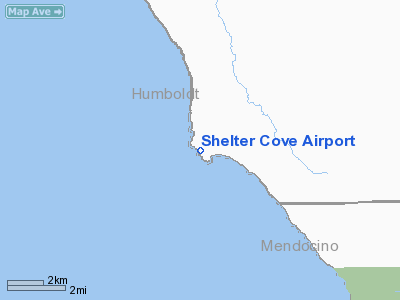
Shelter Cove Airport (FAA LID: 0Q5) is a public airport located one mile (1.6 km) west of Shelter Cove, serving Humboldt County, California, USA. This general aviation airport covers 50 acres and has one runway.
The proximity to the ocean and on-field restaurant make the Shelter Cove Airport a popular fly-in destination when weather permits.
Accidents and incidents
- On 28 June 1971, Douglas C-47 N90627 of Lake Riverside Estates crashed on take-off on a domestic non-scheduled passenger flight to San Jose International Airport. Seventeen of the 24 people on board were killed. The cause of the accident was that flight was attempted with the rudder and elevator gust locks in place. Inadequate pre-flight inspection was a contributory factor.
The above content comes from Wikipedia and is published under free licenses – click here to read more.
Location
& QuickFacts
|
FAA
Information Effective: |
2006-09-28 |
|
Airport
Identifier: |
0Q5 |
|
Longitude/Latitude: |
124-04-24.1100W/40-01-39.5160N
-124.073364/40.027643 (Estimated) |
|
Elevation: |
69 ft / 21.03 m (Estimated) |
|
Land: |
50 acres |
|
From
nearest city: |
1 nautical miles W of Shelter Cove, CA |
|
Location: |
Humboldt County, CA |
|
Magnetic Variation: |
17E (1985) |
Owner
& Manager
|
Ownership: |
Publicly owned |
|
Owner: |
Shelter Cove Resort
IMP. DIST. |
|
Address: |
9126 Shelter Cove Drive
Whitehorn, CA 95589 |
|
Phone
number: |
707-986-7447 |
|
Manager: |
Richard Culp |
|
Address: |
9126 Shelter Cove Drive
Whitehorn, CA 95589 |
|
Phone number: |
707-986-7361 |
Airport
Operations and Facilities
|
Airport
Use: |
Open to public |
|
Wind
indicator: |
Yes |
|
Segmented
Circle: |
Yes |
|
Control
Tower: |
No |
|
Attendance
Schedule: |
UNATNDD |
|
Landing
fee charge: |
No |
|
Sectional
chart: |
Klamath Falls |
|
Region: |
AWP - Western-Pacific |
|
Traffic
Pattern Alt: |
1000 ft |
|
Boundary
ARTCC: |
ZOA - Oakland |
|
Tie-in
FSS: |
OAK - Oakland |
|
FSS
on Airport: |
No |
|
FSS
Phone: |
510-273-6111 |
|
FSS
Toll Free: |
1-800-WX-BRIEF |
|
NOTAMs
Facility: |
OAK (NOTAM-d service avaliable) |
|
Federal Agreements: |
N |
Airport
Communications
Airport
Services
|
Airframe
Repair: |
NONE |
|
Power
Plant Repair: |
NONE |
|
Runway Information
Runway 12/30
|
Dimension: |
3400 x 75 ft / 1036.3 x 22.9 m |
|
Surface: |
ASPH, Good Condition |
|
Weight
Limit: |
Single wheel: 20000 lbs. |
|
|
Runway 12 |
Runway 30 |
|
Traffic
Pattern: |
Right |
Left |
|
Markings: |
Basic, Good Condition |
Basic, Good Condition |
|
Displaced
threshold: |
100.00 ft |
500.00 ft |
|
Runway
End Identifier: |
No |
No |
|
Centerline
Lights: |
No |
No |
|
Touchdown
Lights: |
No |
No |
|
Obstruction: |
10 ft tree, 400.0 ft from runway, 150 ft left
of centerline, 20:1 slope to clear |
60 ft tree, 1000.0 ft from runway, 190 ft right
of centerline, 13:1 slope to clear
APCH RATIO 22:1 TO DSPLCD THLD, 37 FT TREE 191 FT R 341 FT
FM EOR.. |
|
Radio Navigation
Aids
|
ID |
Type |
Name |
Ch |
Freq |
Var |
Dist |
|
FOT |
VORTAC |
Fortuna |
087X |
114.00 |
19E |
39.4 nm |
Remarks
- ARPT
USE RESTRICTED BY AMGR TO ACFT HAVING A MAXIMUM CERTIFICATED GROSS TKOF
WGT OF 12,500 LBS OR LESS; CTC AMGR FOR ADDITIONAL INFO (707)986-7447.
- STUDENT
PILOT SOLO FLIGHTS PROHIBITED.
- NO
PRACTICE LOW APCHS OR TOUCH AND GO LANDINGS.
- BE
ALERT FOR ULTRA-LIGHTS, HANGLIDERS AND PARACHUTERS INVOF ARPT.
- GOLF
CARTS OPERATING ON AND INVOF ARPT.
- EXPECT
CROSSWINDS, DOWNDRAFTS AND EXTDD PERIODS OF FOG YEAR-ROUND.
- TERRAIN
+40 FT DROP OFF LCTD 240 FT NORTH APCH END RY 12.
Operational Statistics
|
Aircraft
Operations: |
293/Week |
|
General
Aviation Local: |
13.2% |
|
General
Aviation Itinerant: |
85.5% |
|
Military: |
1.3% |
Shelter Cove Airport
Address:
Humboldt County, CA
Tel:
707-986-7447,
707-986-7361
Images
and information placed above are from
http://www.airport-data.com/airport/0Q5/
We
thank them for the data!
| General
Info |
| Country |
United
States |
| State |
CALIFORNIA
|
| FAA ID |
0Q5
|
| Latitude |
40-01-39.516N
|
| Longitude |
124-04-24.110W
|
| Elevation |
69 feet
|
| Near City |
SHELTER
COVE |
We don't guarantee the information is fresh and accurate. The data may
be wrong or outdated.
For more up-to-date information please refer to other sources.
|
|


