 |
|
| Santa Ynez Airport |
| IATA: SQA – ICAO: KIZA – FAA LID: IZA |
| Summary |
| Airport type |
Public |
| Operator |
County of Santa Barbara |
| Location |
Santa Ynez, California |
| Elevation AMSL |
671 ft / 205 m |
| Coordinates |
34°36′25″N 120°04′32″W / 34.60694°N 120.07556°W / 34.60694; -120.07556Coordinates: 34°36′25″N 120°04′32″W / 34.60694°N 120.07556°W / 34.60694; -120.07556 |
| Runways |
| Direction |
Length |
Surface |
| ft |
m |
| 8/26 |
2,804 |
855 |
Asphalt |
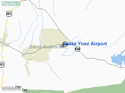
Santa Ynez Airport (IATA: SQA, ICAO: KIZA, FAA LID: IZA) is a public airport located one mile (2 km) southeast of the central business district of Santa Ynez, in the Santa Ynez Valley of Santa Barbara County, California, United States. The airport covers 125 acres (51 ha) and has one runway.
Although most U.S. airports use the same three-letter location identifier for the FAA and IATA, Santa Ynez is assigned IZA by the FAA and SQA by the IATA. The airport's ICAO identifier is KIZA.
The above content comes from Wikipedia and is published under free licenses – click here to read more.
Location
& QuickFacts
|
FAA
Information Effective: |
2006-09-28 |
|
Airport
Identifier: |
IZA |
|
Longitude/Latitude: |
120-04-32.0220W/34-36-24.5530N
-120.075562/34.606820 (Estimated) |
|
Elevation: |
671 ft / 204.52 m (Surveyed) |
|
Land: |
125 acres |
|
From
nearest city: |
1 nautical miles SE of Santa Ynez, CA |
|
Location: |
Santa Barbara County, CA |
|
Magnetic Variation: |
14E (2000) |
Owner
& Manager
|
Ownership: |
Publicly owned |
|
Owner: |
County Of Santa Barbara |
|
Address: |
123 East Anapamu, P.o. Box 91610
Santa Barbara, CA 93190-1610 |
|
Phone
number: |
805-568-3037 |
|
Manager: |
Kim Joos |
|
Address: |
900 Airport Road, P.o. Box 1572
Santa Ynez, CA 93460 |
|
Phone number: |
805-688-8390 |
Airport
Operations and Facilities
|
Airport
Use: |
Open to public |
|
Wind
indicator: |
Yes |
|
Segmented
Circle: |
Yes |
|
Control
Tower: |
No |
|
Attendance
Schedule: |
ALL/ALL/0700-1900 |
|
Lighting
Schedule: |
DUSK-DAWN
MIRL RY 08/26 PRESET LOW INTST TO INCR INTST & ACTVT
VASI RY 26 & TWY LGTS - CTAF. |
|
Beacon
Color: |
Clear-Green (lighted land airport) |
|
Landing
fee charge: |
No |
|
Sectional
chart: |
Los Angeles |
|
Region: |
AWP - Western-Pacific |
|
Traffic
Pattern Alt: |
1000 ft |
|
Boundary
ARTCC: |
ZLA - Los Angeles |
|
Tie-in
FSS: |
HHR - Hawthorne |
|
FSS
on Airport: |
No |
|
FSS
Phone: |
310-970-0102 |
|
FSS
Toll Free: |
1-800-WX-BRIEF |
|
NOTAMs
Facility: |
IZA (NOTAM-d service avaliable) |
|
Federal Agreements: |
NGY |
Airport
Communications
|
CTAF: |
122.800 |
|
Unicom: |
122.800 |
Airport
Services
|
Fuel
available: |
100LLA
FUEL AVBL 24 HRS USING AUTOMATED SYSTEM. |
|
Airframe
Repair: |
MAJOR |
|
Power
Plant Repair: |
MAJOR |
|
Bottled
Oxygen: |
NONE |
|
Bulk
Oxygen: |
NONE |
|
Runway Information
Runway 08/26
|
Dimension: |
2804 x 75 ft / 854.7 x 22.9 m |
|
Surface: |
ASPH, Good Condition |
|
Weight
Limit: |
Single wheel: 12500 lbs. |
|
Edge
Lights: |
Medium |
|
|
Runway 08 |
Runway 26 |
|
Longitude: |
120-04-48.5790W |
120-04-15.3790W |
|
Latitude: |
34-36-26.5250N |
34-36-22.5540N |
|
Elevation: |
652.00 ft |
671.00 ft |
|
Alignment: |
98 |
127 |
|
Traffic
Pattern: |
Right |
Left |
|
Markings: |
Non-precision instrument, Good Condition |
Basic, Fair Condition |
|
Crossing
Height: |
0.00
ft |
20.00
ft |
|
VASI: |
|
2-box on left side |
|
Visual
Glide Angle: |
0.00� |
3.40� |
|
Runway
End Identifier: |
No |
No |
|
Centerline
Lights: |
No |
No |
|
Touchdown
Lights: |
No |
No |
|
Obstruction: |
17 ft hill, 750.0 ft from runway, 150 ft left
of centerline, 32:1 slope to clear |
, 50:1 slope to clear |
|
Radio Navigation
Aids
|
ID |
Type |
Name |
Ch |
Freq |
Var |
Dist |
|
VBG |
TACAN |
Vandenberg |
059Y |
|
15E |
26.2 nm |
|
GLJ |
VOR |
Guadalupe |
|
111.00 |
16E |
30.3 nm |
|
GVO |
VORTAC |
Gaviota |
085X |
113.80 |
16E |
4.6 nm |
|
RZS |
VORTAC |
San Marcus |
096X |
114.90 |
14E |
16.2 nm |
|
FLW |
VORTAC |
Fellows |
122X |
117.50 |
16E |
31.0 nm |
Remarks
- RWY
26 TKOF RCMD HEADING 210 DEG. AT ARPT PERIMETER IF SAFETY PMT FOR NOISE
ABATEMENT.
-
< RWY
TFC RIGHT OPERG GLIDERS 26; ZONE APCH DIRT ON OPNS>
- ULTRALIGHT
OPNS SOUTH OF RWY 08/26.
Based Aircraft
|
Aircraft
based on field: |
143 |
|
Single
Engine Airplanes: |
105 |
|
Multi
Engine Airplanes: |
12 |
|
Helicopters: |
4 |
|
Gliders: |
15 |
|
Ultralights: |
7 |
Operational Statistics
|
Aircraft
Operations: |
80/Day |
|
Air Taxi: |
1.6% |
|
General
Aviation Local: |
40.0% |
|
General
Aviation Itinerant: |
58.0% |
|
Military: |
0.4% |
Santa Ynez Airport
Address:
Santa Barbara County, CA
Tel:
805-568-3037,
805-688-8390
Images
and information placed above are from
http://www.airport-data.com/airport/IZA/
We
thank them for the data!
| General
Info |
| Country |
United
States |
| State |
CALIFORNIA
|
| FAA ID |
IZA
|
| Latitude |
34-36-24.553N
|
| Longitude |
120-04-32.022W
|
| Elevation |
671 feet
|
| Near City |
SANTA
YNEZ |
We don't guarantee the information is fresh and accurate. The data may
be wrong or outdated.
For more up-to-date information please refer to other sources.
|
|

