|
|
Santa Monica Municipal Airport |
Santa Monica Airport
Santa Monica Municipal Airport |
 |
| IATA: SMO – ICAO: KSMO – FAA LID: SMO |
| Summary |
| Airport type |
Public |
| Owner |
City of Santa Monica |
| Location |
Santa Monica, California |
| Elevation AMSL |
177 ft / 53.9 m |
| Coordinates |
34°00′57″N 118°27′05″W / 34.01583°N 118.45139°W / 34.01583; -118.45139 |
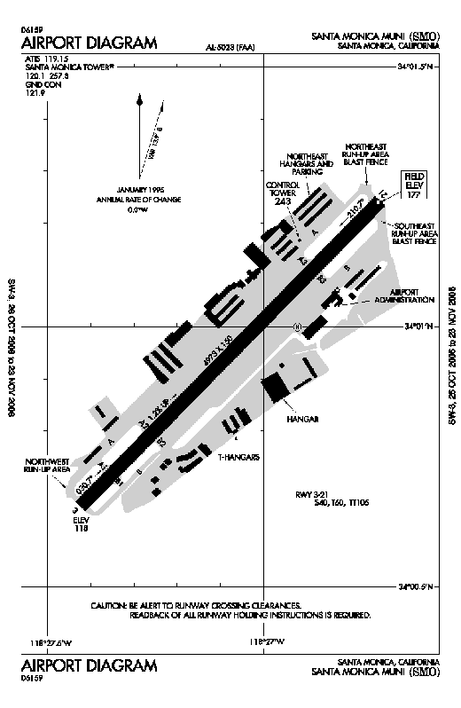
| Runways |
| Direction |
Length |
Surface |
| ft |
m |
| 3/21 |
4,973 |
1,516 |
Asphalt |
| Helipads |
| Number |
Length |
Surface |
| ft |
m |
| H1 |
40 |
12 |
Asphalt |
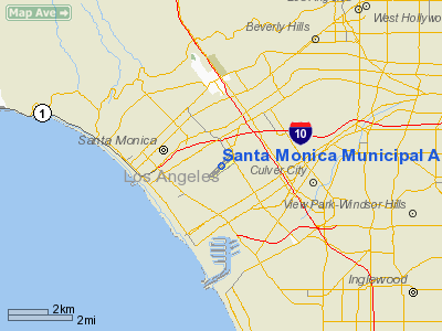
Santa Monica Airport (IATA: SMO, ICAO: KSMO, FAA LID: SMO), also known as Santa Monica Municipal Airport, is a general aviation airport located in the heart of the residential community of Santa Monica, California, United States. The airport is located approximately six statute miles north of LAX and one mile (1.6 km) east of the Santa Monica Bay (Pacific Ocean). Van Nuys Airport is 12 miles (19 km) to the north. According to the FAA's National Plan of Integrated Airport Systems for 2009–2013, it is categorized as a reliever airport. History
Originally called Clover Field, after World War I aviator lieutenant Greayer "Grubby" Clover, the airport was the home of the Douglas Aircraft company. The first circumnavigation of the world by air, accomplished by the U.S. Army with Douglas World Cruisers, took off from Clover Field on St. Patrick's day, March 17, 1924, and returned there after some 28,000 miles (45,000 km). Cloverfield Boulevard—which confuses the field's naming for a crop of green rather than a fallen soldier—is a remnant of the airport's original name. Clover Field was once the site of the Army's 40th Division Aviation, 115th Observation Squadron and became a Distribution Center after World War II. Among other important aircraft built there, Douglas manufactured the Bolo B-18 and B-18A bombers there during the war, during which time the entire area was cleverly disguised from the air with the construction of a false "town" (built with the help of Hollywood craftsman) suspended atop it.
On May 19, 1938, at the request of Santa Monica Postmaster Philip T. Hill (father of race car driver Phil Hill), Joanne Reid (later Jackson) became the first woman to fly the U.S. Mail from Clover Field to Burbank Airport (LAX wasn't yet built) as part of National Air Mail week. She was 22. She was born in Detroit, MI on November 8, 1915 and moved to Santa Monica with her family as a young girl. After accompanying a friend in his family's plane, she became hooked on flying and began taking flying lessons at Clover Field when she was 16. Her flying memorabilia will be featured at the Spring/Summer 2010 re-opening of the Santa Monica History Museum and at the late 2010 re-opening of the Santa Monica Museum of Flying.
Operations
 | |
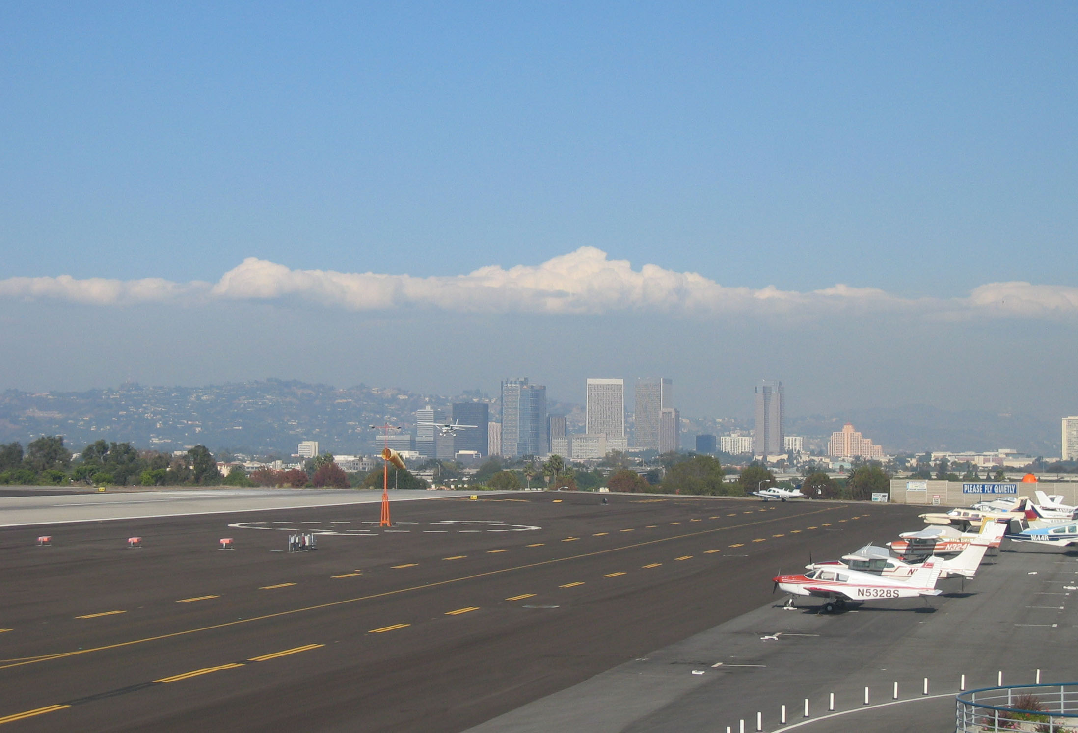
Facing east at the city and landing aircraft. |
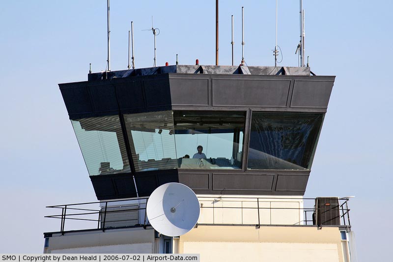
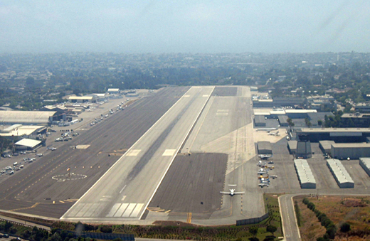
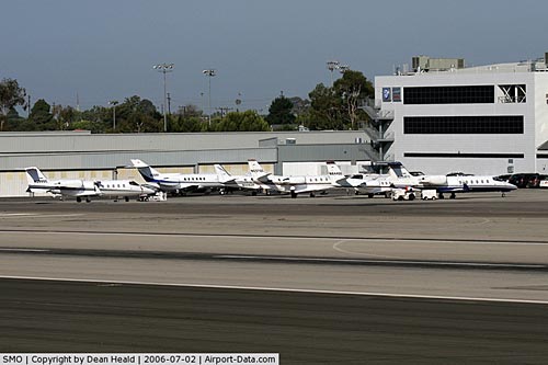
The airport has a control tower and, on average, handles 400-500 operations a day. Jet air traffic has increased substantially in recent years - 18,000 annually, from 1,000 in 1984. This is partly due to the ease of access from Hollywood, and partly due to increased fees associated with fewer access slots at LAX.
In an effort to peacefully coexist with the residents that live in the upscale western Los Angeles County the city of Santa Monica has strict noise ordinances [1] that prohibit takeoffs between the hours of 11 p.m. and 7 a.m. on weekdays and between 11 p.m. and 8 a.m. on weekends as well as other procedures to minimize the noise impact on nearby residents.
Typhoon is the only restaurant on the airport property with a runway view and Spitfire Grill is across on airport street with no view of the runway. The Museum of Flying at the airport houses a collection of historic aircraft. It is currently closed while a new facility is built on the South side of the airport and is expected to re-open at some point in the future. One of the airport's oldest buildings, next to the restored Douglas DC-3, hosts the U.S. Civil Air Patrol's Clover Field Composite Squadron 51.
Landing fees
On August 1, 2005, the Santa Monica City Council implemented a revised landing fee program (Resolution No. 9855) for all transient aircraft (those not based at the Santa Monica Airport) based on a uniform rate of $2.07 per 1000 pounds of Maximum Certificated Gross Landing Weight. Since the Santa Monica Airport receives no federal, state or local funding to operate, the landing fees fill the gap between other Airport revenue and the cost of operations.
Safety concerns
 | |
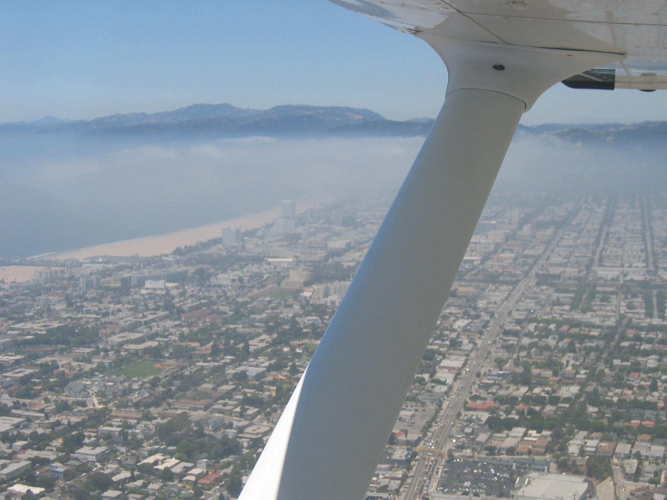
Less than one mile west of Santa Monica Airport over the dense West Los Angeles, California area. |
Around 2005, City of Santa Monica Airport Commission voted a proposal to take away airport land to restore the safety perimeter around the runways that has been eroded by nearby residential development, to protect residences in the event of an aircraft accident. Part of the land opened as an 8.3-acre (34,000 m) public park on non-aviation lands at the southeast corner of the Airport. The new park, known as Airport Park, features a synthetic turf soccer field, open green space and an off-leash dog area.
However, the long term effects of this proposal places the city at odds with the FAA, which is concerned that a shortening of the existing runway will result in heavier air traffic being diverted to LAX. City officials were reported to be surprised at the FAA's position on the matter. "I believe the City was blindsided by the fact that the FAA finds only half the safety (footage) acceptable," said Commission Chair Mark Young. "The only compromise has been on the City's part… yet we have been asked to compromise further." A response from the FAA regarding the passage of this proposal is expected on August 3, 2007.
Pollution
California Assembly Bill 700 (AB 700) would require the California Air Resources Board (CARB) to study the amount of time that turbine aircraft engines run pre-take-off to help determine the extent of this danger. This bill is supported by residents and environmentalists [2] but opposed by business interests who have a financial stake in the increased airport operations.[3]
Future
 | |
Approaching Santa Monica Airport from the east |
The Santa Monica Airport, which is owned by the city of Santa Monica, is dedicated to aviation uses for perpetuity. In 2015, some airport supporters believe the city may try to close the airport and use the land for some other purpose.
Accidents
- In 1994, the pilot of a single-engine Piper Saratoga died when a fuel system misconfiguration led to an in-flight engine shutdown. The aircraft stalled in a subsequent 180 degree turn for a forced emergency landing and struck the ground, which resulted in a post-crash fire.
- On March 28, 2001, an inexperienced pilot rented a Cessna 172 from Justice Aviation at the airport and subsequently lost control of the aircraft over the Pacific Ocean upon encountering dark, instrument meteorological conditions. Three were killed.
- On November 13, 2001, the pilot of a twin-engine Cessna failed to remove the device that locks the control system for parking (to prevent wind damage) and two were killed when the aircraft overran the runway after an unsuccessful aborted takeoff.
- Game-show host Peter Tomarken and his wife Kathleen died when his Beechcraft Bonanza crashed during climb-out from the airport on the morning of March 13, 2006. The Federal Aviation Administration reported that the aircraft had engine trouble and attempted to turn back before crashing into Santa Monica Bay.
- On January 13, 2008, a home-built aircraft ran off the end of runway 21 after a brake failure, jumped over the hillside, landing on a service road. The three passengers on board were not hurt although the kit-built aircraft was damaged severely. The runway was closed for 20 minutes.
- On January 28, 2009, a single-engine SIAI-Marchetti SF-260C lost power following takeoff and attempted to return to the airport. The aircraft struck the ground on the north side of runway 21 and caught fire, killing two people on board. Paulo Emanuele, the general manager of Airliners.net, was the pilot-in-command, and his passenger was Martin Schaedel, a well-known internet entrepreneur and engineer in his twenties. After an investigation The National Transportation Safety Board determines the probable cause(s) of this accident as follows: The pilot’s failure to select the proper fuel tank for takeoff, which resulted in a loss of engine power. Contributing to the accident was the pilot's failure to maintain aircraft control while attempting a return to runway maneuver..
- On August 2, 2009, a Rutan Long-EZ experienced engine failure after takeoff. The pilot attempted to turn back to the runway but crashed on the taxiway in the process of landing. The pilot, flying alone, was severely injured and the airplane was destroyed.
- On July 1, 2010, a Cessna 152 crashed into the Penmar Golf Course shortly after take-off. The pilot was killed.
The above content comes from Wikipedia and is published under free licenses – click here to read more.
|
 |
(Click on the photo to enlarge) |
|
 |
(Click on the photo to enlarge) |
|
 |
(Click on the photo to enlarge) |
Location
& QuickFacts
|
FAA
Information Effective: |
2006-09-28 |
|
Airport
Identifier: |
SMO |
|
Longitude/Latitude: |
118-27-04.7000W/34-00-57.0000N
-118.451306/34.015833 (Estimated) |
|
Elevation: |
177 ft / 53.95 m (Surveyed) |
|
Land: |
215 acres |
|
From
nearest city: |
3 nautical miles E of Santa Monica, CA |
|
Location: |
Los Angeles County, CA |
|
Magnetic Variation: |
14E (1985) |
Owner
& Manager
|
Ownership: |
Publicly owned |
|
Owner: |
City Of Santa Monica |
|
Address: |
3223 Donald Douglas Loop S.
Santa Monica, CA 90405 |
|
Phone
number: |
310-458-8591 |
|
Manager: |
Robert Trimborn |
|
Address: |
3223 Donald Douglas Loop S.
Santa Monica, CA 90405 |
|
Phone number: |
310-458-8591 |
Airport
Operations and Facilities
|
Airport
Use: |
Open to public |
|
Wind
indicator: |
Yes |
|
Segmented
Circle: |
Yes |
|
Control
Tower: |
Yes |
|
Attendance
Schedule: |
ALL/ALL/ALL |
|
Lighting
Schedule: |
DUSK-DAWN
WHEN ATCT CLSD ACTVT MIRL RY 03/21; VASI RY 03; REIL &
PAPI RY 21 - CTAF. |
|
Beacon
Color: |
Clear-Green (lighted land airport) |
|
Landing
fee charge: |
Yes |
|
Sectional
chart: |
Los Angeles |
|
Region: |
AWP - Western-Pacific |
|
Boundary
ARTCC: |
ZLA - Los Angeles |
|
Tie-in
FSS: |
HHR - Hawthorne |
|
FSS
on Airport: |
No |
|
FSS
Phone: |
310-970-0102 |
|
FSS
Toll Free: |
1-800-WX-BRIEF |
|
NOTAMs
Facility: |
SMO (NOTAM-d service avaliable) |
|
Federal Agreements: |
NGPY3 |
Airport
Communications
|
CTAF: |
120.100 |
|
Unicom: |
122.950 |
Airport
Services
|
Fuel
available: |
100LLA |
|
Airframe
Repair: |
MAJOR |
|
Power
Plant Repair: |
MAJOR |
|
Bottled
Oxygen: |
HIGH |
|
Bulk
Oxygen: |
HIGH |
|
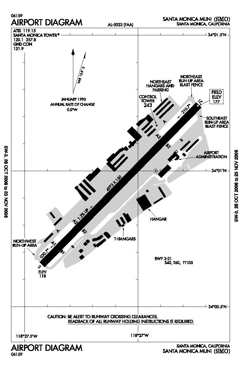
Runway Information
Runway 03/21
|
Dimension: |
4973 x 150 ft / 1515.8 x 45.7 m |
|
Surface: |
ASPH, Good Condition |
|
Weight
Limit: |
Single wheel: 40000 lbs.
Dual wheel: 60000 lbs.
Dual
tandem wheel: 105000 lbs. |
|
Edge
Lights: |
Medium |
|
|
Runway 03 |
Runway 21 |
|
Longitude: |
118-27-25.4272W |
118-26-43.9649W |
|
Latitude: |
34-00-39.4354N |
34-01-14.4762N |
|
Elevation: |
118.00 ft |
177.00 ft |
|
Alignment: |
44 |
127 |
|
ILS
Type: |
|
LDA/DME |
|
Traffic
Pattern: |
Right |
Left |
|
Markings: |
Non-precision instrument, Good Condition |
Non-precision instrument, Good Condition |
|
Crossing
Height: |
27.00 ft |
65.00 ft |
|
VASI: |
4-box on left side |
4-light PAPI on left side |
|
Visual
Glide Angle: |
4.00� |
4.00� |
|
Runway
End Identifier: |
Yes |
Yes |
|
Centerline
Lights: |
No |
No |
|
Touchdown
Lights: |
No |
No |
|
Obstruction: |
45 ft tree, 475.0 ft from runway, 150 ft left
of centerline, 6:1 slope to clear
7' VOR ANT 250' RIGHT OF RY 03 CNTRLN & 100' FM END OF
RY. |
, 50:1 slope to clear
+5' LGT POLE 100' L OF CNTRLN 75' FM END OF RY. |
|
Helipad H1
|
Dimension: |
40 x 40 ft / 12.2 x 12.2 m |
|
Surface: |
ASPH, Good Condition |
|
|
Runway H1 |
Runway |
|
Traffic
Pattern: |
Left |
Left |
|
Markings: |
Basic, Good Condition |
, |
|
Radio Navigation
Aids
|
ID |
Type |
Name |
Ch |
Freq |
Var |
Dist |
|
CPM |
NDB |
Compton |
|
378.00 |
15E |
12.7 nm |
|
PAI |
NDB |
Pacoima |
|
370.00 |
15E |
14.8 nm |
|
EMT |
NDB |
El Monte |
|
359.00 |
15E |
21.4 nm |
|
GWF |
NDB |
Gen William J Fox |
|
282.00 |
15E |
45.0 nm |
|
NTD |
TACAN |
Point Mugu |
043X |
|
15E |
34.0 nm |
|
SMO |
VOR/DME |
Santa Monica |
045X |
110.80 |
15E |
0.4 nm |
|
VNY |
VOR/DME |
Van Nuys |
078X |
113.10 |
15E |
12.6 nm |
|
VTU |
VOR/DME |
Ventura |
019X |
108.20 |
15E |
30.4 nm |
|
CMA |
VOR/DME |
Camarillo |
105X |
115.80 |
15E |
34.1 nm |
|
ELB |
VOR/DME |
El Toro |
119X |
117.20 |
14E |
41.4 nm |
|
LAX |
VORTAC |
Los Angeles |
083X |
113.60 |
15E |
5.1 nm |
|
SLI |
VORTAC |
Seal Beach |
104X |
115.70 |
15E |
24.2 nm |
|
FIM |
VORTAC |
Fillmore |
072X |
112.50 |
15E |
29.6 nm |
|
POM |
VORTAC |
Pomona |
041X |
110.40 |
15E |
33.3 nm |
|
SXC |
VORTAC |
Santa Catalina |
051X |
111.40 |
15E |
38.5 nm |
|
LHS |
VORTAC |
Lake Hughes |
021X |
108.40 |
15E |
40.6 nm |
|
PMD |
VORTAC |
Palmdale |
092X |
114.50 |
15E |
41.7 nm |
|
PDZ |
VORTAC |
Paradise |
059X |
112.20 |
15E |
46.3 nm |
|
LAX |
VOT |
San Pedro Hill |
|
113.90 |
|
17.2 nm |
|
SNA |
VOT |
Santa Ana |
|
110.00 |
|
35.5 nm |
Remarks
- PPR
REQUIRED FOR DUAL WHEEL ACFT IN EXCESS OF 60,000 LBS CERTIFIED MAX LNDG
WGT, CTC AMGR (310) 458-8591.
- NO
TOUCH/GO, STOP/GO, OR LOW APCH PERMITTED ON SAT, SUN, HOLS; WEEKDAYS
SS-0700.
- VFR
DEPS RY 21 TURN LEFT 10 DEGREES AT END OF RY THEN TURN RIGHT 225 DEG
TO OVER-FLY GOLF COURSE W OF ARPT. NO CROSSWIND TURN UNTIL REACHING
LINCOLN BLVD (1 MILE W) AND OUT 800 FT MSL
- IF
DEP PATTERN, NO TURN BEFORE REACHING SHORELINE. RY 03 DEP NO TURN PRIOR
TO FREEWAY LCTD 1 MILE EAST.
- ENGINE
MAINTENANCE RUNUP: JETS AND TURBOPROP NORTH SIDE, WITHIN 300 FT EAST
OF TWY A3. PISTON SINGLE AND TWINS ON SOUTH SIDE, WITHIN 300 FT EAST
OF TWY B3.
- CONTINUOUS
NOISE ORDINANCE IN EFFECT CTC NOISE OFFICE PRIOR TO ARRIVAL (310) 458-8759/8692
OR (310) 434-2640.
- NOISE
ABATEMENT PROCEDURES: PURE JET AND STAGE II (WITH/WITHOUT HUSHKITS)
PROHIBITED. MAX
MOISE LIMIT 95.0 SENEL ALL ACFT.
- PPR
EX-MILITARY ACFT CTC AMGR (310) 458-8591.
- CURFEW:
NO ENGINE STARTS OR DEPS EXPECT PPR LIFEGUARD FLTS 2300-0700 MON-FRI
AND 2300-0800 WKENDS.
- NOISE
TESTS ON 122.85.
- HEL
FLT TRNG OPN PROHIBITED; HEL OPNS APCH ARPT BDRY AT MIDFIELD AT OR ABOVE
900 FT MSL.
- INTXN
DEPS AND FORMATION LNDGS/DEPS PROHIBITED.
- RY
03/21 DEP END APPROX 220 FT FM RESIDENTIAL HOMES. EXTENDED HIGH POWER
SETTINGS ON RUN-UP OR DEP NEGATIVELY IMPACT THE COMMUNITY.
Based Aircraft
|
Aircraft
based on field: |
408 |
|
Single
Engine Airplanes: |
345 |
|
Multi
Engine Airplanes: |
53 |
|
Jet Engine
Airplanes: |
7 |
|
Helicopters: |
3 |
Operational Statistics
|
Aircraft
Operations: |
453/Day |
|
Air Taxi: |
7.1% |
|
General
Aviation Local: |
30.5% |
|
General
Aviation Itinerant: |
61.3% |
|
Military: |
1.1% |
Santa Monica Municipal Airport
Address:
Los Angeles County, CA
Tel:
310-458-8591
Images
and information placed above are from
http://www.airport-data.com/airport/SMO/
We
thank them for the data!
| General
Info |
| Country |
United
States |
| State |
CALIFORNIA
|
| FAA ID |
SMO
|
| Latitude |
34-00-56.959N
|
| Longitude |
118-27-04.666W
|
| Elevation |
175 feet
|
| Near City |
SANTA
MONICA |
We don't guarantee the information is fresh and accurate. The data may
be wrong or outdated.
For more up-to-date information please refer to other sources.
|
|