|
|
Santa Maria Public/capt G Allan Hancock Field Airport |
Santa Maria Public Airport
Capt. G. Allan Hancock Field |
 |
 |
| 1994 USGS Photo |
| IATA: SMX – ICAO: KSMX – FAA LID: SMX |
| Summary |
| Airport type |
Public |
| Owner |
Santa Maria Public Airport District |
| Serves |
Santa Maria, California |
| Elevation AMSL |
261 ft / 80 m |
| Website |
SantaMariaAirport.com |
| Runways |
| Direction |
Length |
Surface |
| ft |
m |
| 12/30 |
6,304 |
1,921 |
Asphalt |
| 2/20 |
5,130 |
1,564 |
Asphalt |
| Statistics (2007) |
| Aircraft operations |
62,480 |
| Based aircraft |
243 |
| Source: FAA, airport website |
Coordinates: 34°53′56″N 120°27′27″W / 34.89889°N 120.4575°W / 34.89889; -120.4575
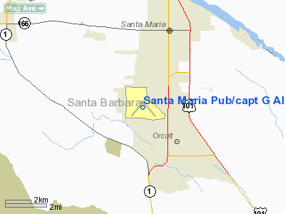
Santa Maria Public Airport (IATA: SMX, ICAO: KSMX, FAA LID: SMX), also known as the Capt. G. Allan Hancock Field, is an airport located three miles (5 km) south of the central business district of Santa Maria, a city in northern Santa Barbara County, California, United States. History
The airport was built by the United States Army during World War II, known as Santa Maria Army Air Field. Its primary mission was to provide training for B-25 pilots, however flight training was abandoned by December 1942. The field fell into a state of disuse until the arrival of the P-38 in September 1943.
After the war, Santa Barbara County and the City of Santa Maria acquired the land and facilities through a series of two grants in 1948. In 1964 the Army Air Field was renamed Santa Maria Public Airport.
Facilities and aircraft
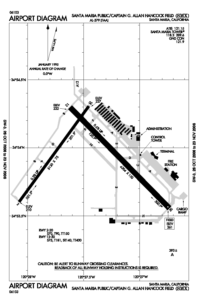
Santa Maria Public Airport covers an area of 2,516 acres (1,018 ha) which contains two asphalt paved runways: 12/30 measuring 6,304 x 150 ft (1,921 x 46 m) and 2/20 measuring 5,130 x 75 ft (1,564 x 23 m).
For the 12-month period ending December 31, 2007, the airport had 62,480 aircraft operations, an average of 171 per day: 79% general aviation, 19% air taxi, 2% military and <1% scheduled commercial. There are 243 aircraft based at this airport: 83% single-engine, 7% multi-engine, 6% helicopter, 3% jet, <1% glider and <1% ultralight.
Expansion
The airport hopes to expand one of its runways in the hope to attract new airlines. Allegiant Air has also expanded air service from Las Vegas to Santa Maria adding a Monday flight to its schedule. Airport officials have recently opened the new, approximately 4,000-square-foot (370 m) baggage claim facility, and have repaired the cracks in the floor. It is one of the first airports on the Central Coast to use a state of the art baggage carousel (in a smaller scale) to deliver luggage to passengers.
A new passenger terminal holding room was recently opened. The old area was able to accommodate only 30 passengers. To handle the larger crowds of passengers that Allegiant Air flights bring, the new holding room accommodates 200 passengers and has enough room for a new cafe.
Usage
Nov 2007 to October 2008: 56,553 passengers (SkyWest), 53,294 passengers (Allegiant), total 109,847 passengers. Nov 2008 to October 2009, 48,117 passengers (SkyWest), 37,570 passengers (Allegiant), total 85,687 passengers.
Airlines and destinations
| Airlines |
Destinations |
| Allegiant Air |
Las Vegas |
| United Express operated by SkyWest Airlines |
Los Angeles |
The above content comes from Wikipedia and is published under free licenses – click here to read more.
Location
& QuickFacts
|
FAA
Information Effective: |
2006-09-28 |
|
Airport
Identifier: |
SMX |
|
Longitude/Latitude: |
120-27-26.8000W/34-53-56.1000N
-120.457444/34.898917 (Estimated) |
|
Elevation: |
261 ft / 79.55 m (Surveyed) |
|
Land: |
2516 acres |
|
From
nearest city: |
3 nautical miles S of Santa Maria, CA |
|
Location: |
Santa Barbara County, CA |
|
Magnetic Variation: |
15E (1985) |
Owner
& Manager
|
Ownership: |
Publicly owned |
|
Owner: |
Santa Maria Public Apt Dist |
|
Address: |
3217 Terminal Dr
Santa Maria, CA 93455 |
|
Phone
number: |
805-922-1726 |
|
Manager: |
Gary T. Rice |
|
Address: |
3217 Terminal Dr
Santa Maria, CA 93455 |
|
Phone number: |
805-922-1726 |
Airport
Operations and Facilities
|
Airport
Use: |
Open to public |
|
Wind
indicator: |
Yes |
|
Segmented
Circle: |
Yes |
|
Control
Tower: |
Yes |
|
Attendance
Schedule: |
ALL/ALL/0600-2200
FOR ATTENDANT AFTER HOURS CALL (805) 928-9431. |
|
Lighting
Schedule: |
DUSK-DAWN
WHEN ATCT CLSD ACTVT MALSR RY 12 - CTAF. HIRL RY 12/30 AND
VASI RY 30 OPER CONTINUOUSLY. ACTVT TWY LGTS 0000-0600 - CTAF. |
|
Beacon
Color: |
Clear-Green (lighted land airport) |
|
Landing
fee charge: |
No |
|
Sectional
chart: |
Los Angeles |
|
Region: |
AWP - Western-Pacific |
|
Boundary
ARTCC: |
ZLA - Los Angeles |
|
Tie-in
FSS: |
HHR - Hawthorne |
|
FSS
on Airport: |
No |
|
FSS
Phone: |
310-970-0102 |
|
FSS
Toll Free: |
1-800-WX-BRIEF |
|
NOTAMs
Facility: |
SMX (NOTAM-d service avaliable) |
|
Certification
type/date: |
I AU 5/1973
CLSD TO ACR OPNS WITH MORE THAN 30 PSGR SEATS EXCP 24 HRS
PPR CALL AMGR (805) 922-1726 WKDAYS 0800-1700. DECLARED
AIRPORT ARFF INDEX IS 'A' BUT IS CAPABLE OF PROVIDING INDEX
'B'. |
|
Federal Agreements: |
NGPY |
Airport
Communications
|
CTAF: |
118.300 |
|
Unicom: |
122.950 |
Airport
Services
|
Fuel
available: |
100LLA |
|
Airframe
Repair: |
MAJOR |
|
Power
Plant Repair: |
MAJOR |
|
Runway Information
Runway 02/20
|
Dimension: |
5130 x 75 ft / 1563.6 x 22.9 m |
|
Surface: |
ASPH, Good Condition |
|
Weight
Limit: |
Single wheel: 70000 lbs.
Dual wheel: 90000 lbs.
Dual
tandem wheel: 150000 lbs. |
|
|
Runway 02 |
Runway 20 |
|
Longitude: |
120-28-04.5308W |
120-27-28.3433W |
|
Latitude: |
34-53-36.1801N |
34-54-17.2311N |
|
Elevation: |
210.00 ft |
227.00 ft |
|
Alignment: |
36 |
127 |
|
Traffic
Pattern: |
Right |
Left |
|
Markings: |
Basic, Good Condition |
Basic, Good Condition |
|
Runway
End Identifier: |
No |
No |
|
Centerline
Lights: |
No |
No |
|
Touchdown
Lights: |
No |
No |
|
Obstruction: |
, 50:1 slope to clear |
121 ft trees, 3700.0 ft from runway, 350 ft
right of centerline, 28:1 slope to clear |
|
Runway 12/30
|
Dimension: |
6304 x 150 ft / 1921.5 x 45.7 m |
|
Surface: |
ASPH, Good Condition |
|
Surface
Treatment: |
Saw-cut or plastic Grooved |
|
Weight
Limit: |
Single wheel: 75000 lbs.
Dual wheel: 181000 lbs.
Dual
tandem wheel: 400000 lbs. |
|
Edge
Lights: |
High |
|
|
Runway 12 |
Runway 30 |
|
Longitude: |
120-27-37.3398W |
120-26-44.2067W |
|
Latitude: |
34-54-17.8087N |
34-53-33.4038N |
|
Elevation: |
222.00 ft |
261.00 ft |
|
Alignment: |
127 |
127 |
|
ILS
Type: |
ILS/DME |
|
|
Traffic
Pattern: |
Right |
Left |
|
Markings: |
Precision instrument, Good Condition |
Precision instrument, Good Condition |
|
Crossing
Height: |
0.00
ft |
57.00 ft |
|
VASI: |
|
4-box on left side |
|
Visual
Glide Angle: |
0.00� |
3.50� |
|
RVR
Equipment: |
touchdown |
|
|
Approach
lights: |
MALSR |
|
|
Runway
End Identifier: |
No |
No |
|
Centerline
Lights: |
No |
No |
|
Touchdown
Lights: |
No |
No |
|
Obstruction: |
, 50:1 slope to clear |
225 ft trees, 4700.0 ft from runway, 800 ft
left of centerline, 20:1 slope to clear |
|
Radio Navigation
Aids
|
ID |
Type |
Name |
Ch |
Freq |
Var |
Dist |
|
VBG |
TACAN |
Vandenberg |
059Y |
|
15E |
11.8 nm |
|
GLJ |
VOR |
Guadalupe |
|
111.00 |
16E |
4.5 nm |
|
MQO |
VORTAC |
Morro Bay |
071X |
112.40 |
16E |
25.9 nm |
|
GVO |
VORTAC |
Gaviota |
085X |
113.80 |
16E |
28.6 nm |
|
FLW |
VORTAC |
Fellows |
122X |
117.50 |
16E |
31.4 nm |
|
RZS |
VORTAC |
San Marcus |
096X |
114.90 |
14E |
41.2 nm |
|
PRB |
VORTAC |
Paso Robles |
090X |
114.30 |
16E |
47.2 nm |
Remarks
- RUNUP
APRON RY 30 GWT 110,000 LBS DW.
- BE
ALERT TO PAEW 30 FT EAST OF TWY A CTRLN ABEAM TAXILANE A11.
- CALM
WIND LESS THAN 8 KNOTS USE RWY 30.
- NO
TGL OPNS; LANDING PRACTICE OR PRACTICE INSTRUMENT APPROACHES 2200-0700.
- PORTIONS
OF TWY A12 NOT VISIBLE FROM ATCT & UNLGTD.
- ACFT
FUEL SERVICING 122.850 OR 122.950.
- NUMEROUS
BIRDS ON AND INVOF ARPT.
Based Aircraft
|
Aircraft
based on field: |
241 |
|
Single
Engine Airplanes: |
200 |
|
Multi
Engine Airplanes: |
18 |
|
Jet Engine
Airplanes: |
6 |
|
Helicopters: |
14 |
|
Gliders: |
1 |
|
Ultralights: |
2 |
Major Carriers
Serving This Airport
Most Popular Destinations
| Los Angeles Intl (LAX) |
100.0% |
Most Popular Aircraft
|
N565SW |
5.2% |
| N295SW |
4.6% |
|
N237SW |
4.6% |
| N251YV |
4.1% |
|
N293SW |
3.9% |
| N226SW |
3.9% |
|
N234SW |
3.7% |
| N220SW |
2.8% |
|
N268UE |
2.8% |
| N235SW |
2.6% |
Operational Statistics
|
Aircraft
Operations: |
197/Day |
|
Air Carrier: |
0.1% |
|
Air Taxi: |
18.4% |
|
General
Aviation Local: |
37.8% |
|
General
Aviation Itinerant: |
41.6% |
|
Military: |
2.0% |
Santa Maria Pub/capt G Allan Hancock Fld
Airport
Address:
Santa Barbara County, CA
Tel:
805-922-1726
Images
and information placed above are from
http://www.airport-data.com/airport/SMX/
We
thank them for the data!
| General
Info |
| Country |
United
States |
| State |
CALIFORNIA
|
| FAA ID |
SMX
|
| Latitude |
34-53-56.100N
|
| Longitude |
120-27-26.800W
|
| Elevation |
261 feet
|
| Near City |
SANTA
MARIA |
We don't guarantee the information is fresh and accurate. The data may
be wrong or outdated.
For more up-to-date information please refer to other sources.
|
|