|
|
Santa Barbara Municipal Airport |
| Santa Barbara Airport |
 |
 |
| IATA: SBA – ICAO: KSBA – FAA LID: SBA |
| Summary |
| Airport type |
Public |
| Operator |
City of Santa Barbara |
| Serves |
Santa Barbara, California |
| Location |
Santa Barbara, California, United States |
| Elevation AMSL |
10 ft / 3 m |
| Coordinates |
34°25′34″N 119°50′25″W / 34.42611°N 119.84028°W / 34.42611; -119.84028 |
| Website |
Santa Barbara Airport |
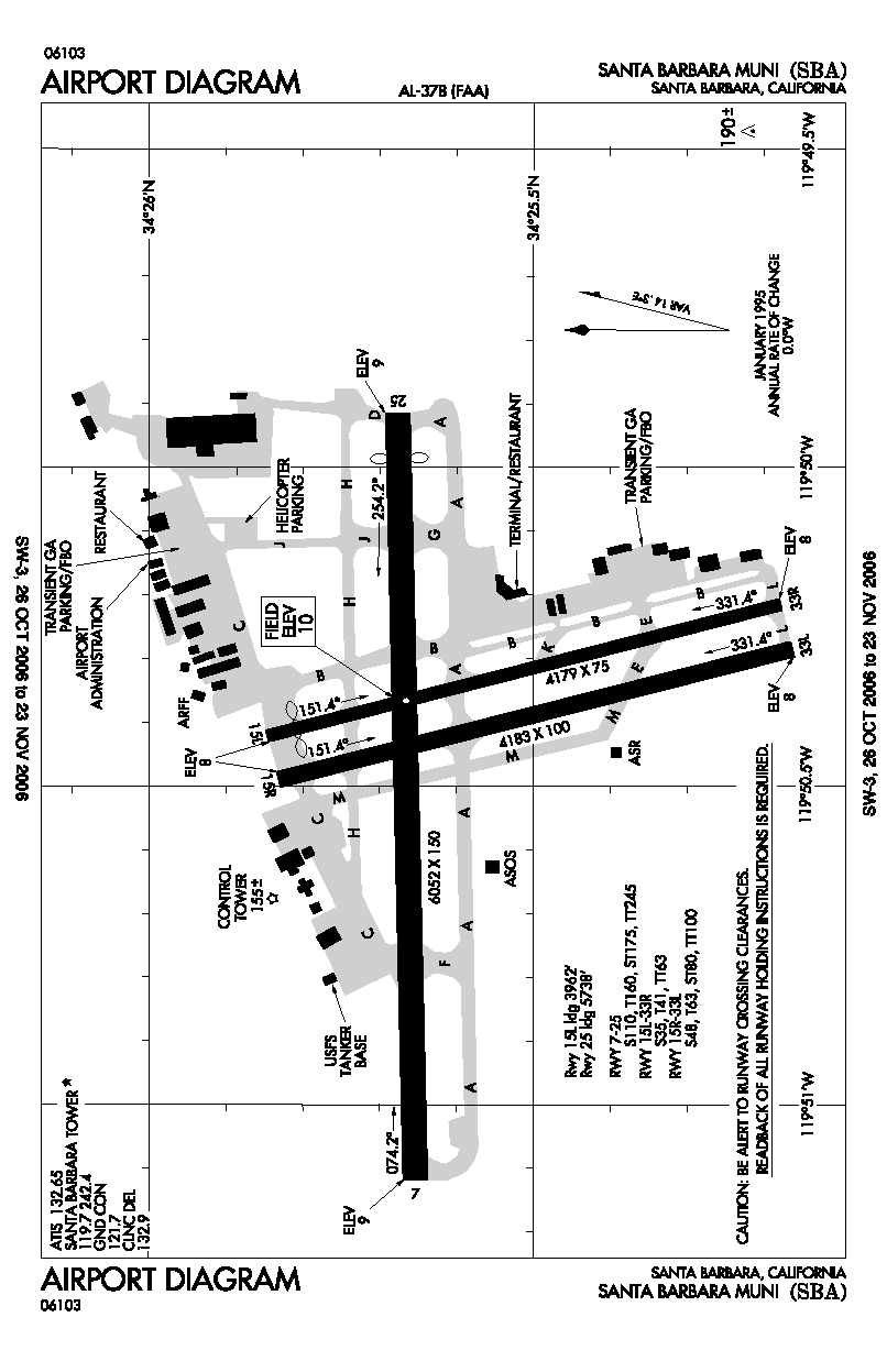
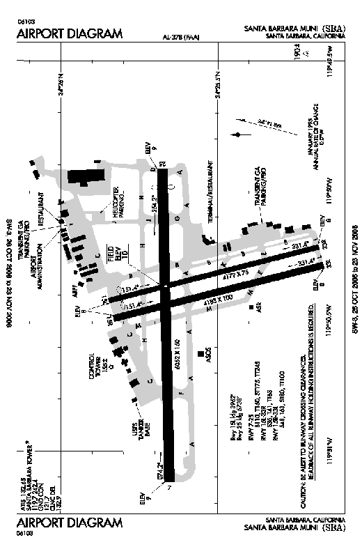
| Runways |
| Direction |
Length |
Surface |
| ft |
m |
| 7/25 |
6,052 |
1,845 |
Asphalt |
| 15L/33R |
4,179 |
1,274 |
Asphalt |
| 15R/33L |
4,183 |
1,275 |
Asphalt |
 |
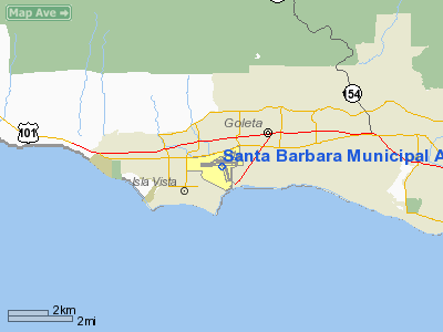
Santa Barbara Airport (IATA: SBA, ICAO: KSBA, FAA LID: SBA), also known as Santa Barbara Municipal Airport, is a public airport located 7 miles (11 km) west of downtown Santa Barbara, California, USA.
The airport is adjacent to the University of California, Santa Barbara and the city of Goleta. However, the land that the airport sits on was annexed to the city of Santa Barbara by a 7 miles (11 km) long, 300 feet (90 m) wide corridor, most of which lies under the Pacific Ocean. This a shoestring annexation. Much of the airport is between 10 and 15 feet above sea level, and it is bordered by the wetland area known as the Goleta Slough.
Six airlines serve the Airport as of July 2009 with nearly 40 daily departures to nine U.S. cities (see below). In 2005, an estimated 900,000 passengers used the airport. It is also a popular training airport. The field is home to three flight schools, Above All Aviation,flight school and FAA approved Aerial Scenic Tour Facilty, Red Baron Aviation, an FAA certified test center and Cessna Pilot Center, as well as Spitfire Aviation. History
Santa Barbara's aviation history began in 1914 when Lincoln J. Beachey flew an airplane across Goleta Valley. Two years later the Loughead brothers, who later changed their name to Lockheed, established a seaplane factory on State Street (Alco Hydro-Aeroplane Company) and constructed a wooden ramp on West Beach to launch their planes. In 1928, Gordon Sackett and Royce Stetson landed a Hisso-powered airplane in a cow pasture near the corner of Hollister and Fairview Avenues and set up a flight school on the spot. That first airstrip marked the beginning of what was to become the Santa Barbara Municipal Airport.
As airplane manufacturing grew in the late 1930s that simple airstrip developed into an airfield. Western General set up shop and began producing Meteor airplanes, while Santa Barbara Airways' founder Frederick Stearns II built two additional runways and two large hangars. Stearns also installed the first radio equipment at the airfield.
Commercial service began in 1932 with Pacific Seaboard Airlines, and United Airlines inaugurated service from Santa Barbara/Goleta in 1936.
As the prospect of war escalated the United States Government established a defense program to construct 250 airports across the country on a cost-sharing basis with local governments. Thomas M. Storke secured Santa Barbara's enrollment in the program, and in 1941 groundbreaking ceremonies were held for the Santa Barbara Municipal Airport. The Spanish-style terminal building, commissioned by United Airlines in 1942 was designed by William Edwards and Joseph Plunkett, an architectural team whose work, including the Arlington Theatre and the National Armory, helped shape the Mediterranean style of the city.
In 1947, the Santa Barbara Flying Club was formed to promote general aviation in the region. The club is still a registered non-profit meeting monthly at the Visitor Center, and working with other groups and businesses to continue making Santa Barbara a great place to fly.
In the 1951 war film Flying Leathernecks, John Wayne's character was stationed in Goleta. The movie references the airbase as being in Goleta because, during World War II, the airbase had not yet been annexed by Santa Barbara. There is a short clip of the airport and surrounding area in the movie.
Three runways are currently used: 7/25 and two parallel runways 15/33. In addition to these runways, the airport originally had an additional strip: runway 3/21. The development of the University of California, Santa Barbara (to the southwest) and the construction of hangars in support of production of the Aero Spacelines Super Guppy (to the northeast) were factors in the abandonment and eventual removal of this runway.
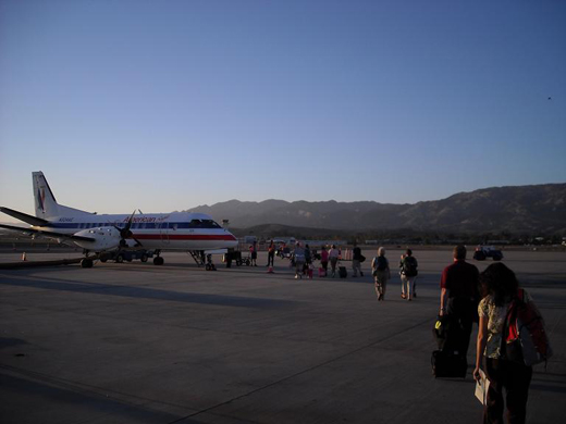 | |
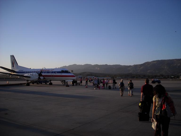
Passengers boarding a Saab 340B turboprop aircraft for a flight to Los Angeles in October 2008. |
Santa Barbara Airport had included mainline service by Shuttle by United until 2002.
Future expansion
In early 2007, Santa Barbara executives tentatively approved a $60 million project to expand the terminal, while keeping the "Santa Barbara Airport Experience” by building around the original 1942 terminal. Some of the features of the redesign are passenger loading bridges, making it so everything is contained in one building including car rentals, security, gates and the baggage tents
Airlines and destinations
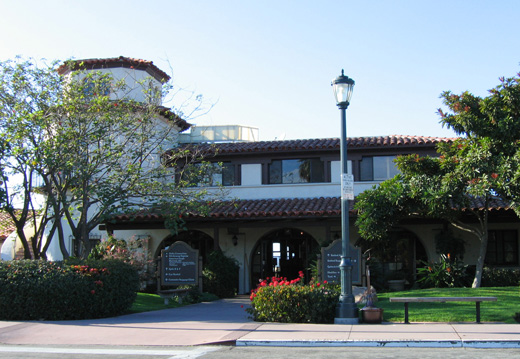
| |
Commercial passenger terminal at Santa Barbara Airport. |
| Airlines |
Destinations |
| American Eagle |
Los Angeles |
| Frontier Airlines operated by Republic Airlines |
Denver |
| Horizon Air |
Seattle/Tacoma |
| United Express operated by SkyWest Airlines |
Denver, Los Angeles, San Francisco |
| US Airways Express operated by Mesa Airlines |
Phoenix |
The above content comes from Wikipedia and is published under free licenses – click here to read more.
Location
& QuickFacts
|
FAA
Information Effective: |
2006-09-28 |
|
Airport
Identifier: |
SBA |
|
Longitude/Latitude: |
119-50-25.3440W/34-25-34.3630N
-119.840373/34.426212 (Estimated) |
|
Elevation: |
10 ft / 3.05 m (Surveyed) |
|
Land: |
948 acres |
|
From
nearest city: |
7 nautical miles W of Santa Barbara, CA |
|
Location: |
Santa Barbara County, CA |
|
Magnetic Variation: |
14E (1985) |
Owner
& Manager
|
Ownership: |
Publicly owned |
|
Owner: |
City Of Santa Barbara |
|
Address: |
City Hall
Santa Barbara, CA 93101 |
|
Phone number: |
805-967-7111 |
|
Manager: |
Karen Ramsdell |
|
Address: |
601 Firestone Rd
Goleta, CA 93117 |
|
Phone number: |
805-967-7111 |
Airport
Operations and Facilities
|
Airport
Use: |
Open to public |
|
Wind
indicator: |
Yes |
|
Segmented
Circle: |
Yes |
|
Control
Tower: |
Yes |
|
Attendance
Schedule: |
ALL/ALL/0530-2200 |
|
Lighting
Schedule: |
DUSK-DAWN
WHEN ATCT CLSD ACTVT MIRL RY 15R/33L - CTAF. |
|
Beacon
Color: |
Clear-Green (lighted land airport) |
|
Landing
fee charge: |
No |
|
Sectional
chart: |
Los Angeles |
|
Region: |
AWP - Western-Pacific |
|
Boundary
ARTCC: |
ZLA - Los Angeles |
|
Tie-in
FSS: |
HHR - Hawthorne |
|
FSS
on Airport: |
No |
|
FSS
Phone: |
310-970-0102 |
|
FSS
Toll Free: |
1-800-WX-BRIEF |
|
NOTAMs
Facility: |
SBA (NOTAM-d service avaliable) |
|
Certification type/date: |
I CS 5/1973 |
|
Federal Agreements: |
NGPY3 |
Airport
Communications
|
CTAF: |
119.700 |
|
Unicom: |
122.950 |
Airport
Services
|
Fuel
available: |
100LLA
FEE FOR FUEL AFTER HRS CALL (805) 964-6733 OR 967-5608. |
|
Airframe
Repair: |
MAJOR |
|
Power
Plant Repair: |
MAJOR |
|
Bottled
Oxygen: |
HIGH/LOW |
|
Bulk
Oxygen: |
HIGH/LOW |
|
Runway Information
Runway 07/25
|
Dimension: |
6052 x 150 ft / 1844.6 x 45.7 m |
|
Surface: |
ASPH, Good Condition |
|
Surface
Treatment: |
Porous Friction Course |
|
Weight
Limit: |
Single wheel: 110000 lbs.
Dual wheel: 160000 lbs.
Dual
tandem wheel: 245000 lbs. |
|
Edge
Lights: |
High |
|
|
Runway 07 |
Runway 25 |
|
Longitude: |
119-51-07.1420W |
119-49-54.9580W |
|
Latitude: |
34-25-39.1760N |
34-25-40.6920N |
|
Elevation: |
9.00
ft |
9.00
ft |
|
Alignment: |
89 |
127 |
|
ILS
Type: |
ILS/DME |
|
|
Traffic
Pattern: |
Right |
Left |
|
Markings: |
Precision instrument, Good Condition |
Precision instrument, Good Condition |
|
Crossing
Height: |
0.00
ft |
46.00 ft |
|
Displaced
threshold: |
0.00
ft |
314.00 ft |
|
VASI: |
|
4-box on left side |
|
Visual
Glide Angle: |
0.00� |
3.00� |
|
RVR
Equipment: |
touchdown |
|
|
Approach
lights: |
MALSR |
|
|
Runway
End Identifier: |
No |
Yes |
|
Centerline
Lights: |
No |
No |
|
Touchdown
Lights: |
No |
No |
|
Obstruction: |
77 ft tree, 3100.0 ft from runway, 350 ft right
of centerline, 37:1 slope to clear |
6 ft fence, 275.0 ft from runway, 12:1 slope
to clear
APCH RATIO 50:1 TO DSPLCD THR. |
|
Runway 15L/33R
|
Dimension: |
4179 x 75 ft / 1273.8 x 22.9 m |
|
Surface: |
ASPH, Good Condition |
|
Weight
Limit: |
Single wheel: 35000 lbs.
Dual wheel: 41000 lbs.
Dual
tandem wheel: 63000 lbs. |
|
|
Runway 15L |
Runway 33R |
|
Longitude: |
119-50-25.3000W |
119-50-12.9430W |
|
Latitude: |
34-25-50.8010N |
34-25-10.7480N |
|
Elevation: |
8.00
ft |
8.00
ft |
|
Alignment: |
127 |
127 |
|
Traffic
Pattern: |
Left |
Right |
|
Markings: |
Basic, Good Condition |
Basic, Good Condition |
|
Displaced
threshold: |
217.00 ft |
0.00
ft |
|
Runway
End Identifier: |
No |
No |
|
Centerline
Lights: |
No |
No |
|
Touchdown
Lights: |
No |
No |
|
Obstruction: |
37 ft bldg, 900.0 ft from runway, 4 ft right
of centerline, 19:1 slope to clear
APCH RATIO 30:1 TO DSPLCD THR. |
, 50:1 slope to clear |
|
Runway 15R/33L
|
Dimension: |
4183 x 100 ft / 1275.0 x 30.5 m |
|
Surface: |
ASPH, Good Condition |
|
Weight
Limit: |
Single wheel: 48000 lbs.
Dual wheel: 63000 lbs.
Dual
tandem wheel: 100000 lbs. |
|
Edge
Lights: |
Medium |
|
|
Runway 15R |
Runway 33L |
|
Longitude: |
119-50-29.4940W |
119-50-17.1230W |
|
Latitude: |
34-25-49.9350N |
34-25-09.8440N |
|
Elevation: |
8.00
ft |
8.00
ft |
|
Alignment: |
127 |
127 |
|
Traffic
Pattern: |
Left |
Right |
|
Markings: |
Basic, Good Condition |
Basic, Good Condition |
|
Runway
End Identifier: |
Yes |
No |
|
Centerline
Lights: |
No |
No |
|
Touchdown
Lights: |
No |
No |
|
Obstruction: |
53 ft tree, 600.0 ft from runway, 200 ft right
of centerline, 8:1 slope to clear |
65 ft tree, 1300.0 ft from runway, 400 ft left
of centerline, 17:1 slope to clear |
|
Radio Navigation
Aids
|
ID |
Type |
Name |
Ch |
Freq |
Var |
Dist |
|
NTD |
TACAN |
Point Mugu |
043X |
|
15E |
40.1 nm |
|
VBG |
TACAN |
Vandenberg |
059Y |
|
15E |
41.1 nm |
|
GLJ |
VOR |
Guadalupe |
|
111.00 |
16E |
46.2 nm |
|
CMA |
VOR/DME |
Camarillo |
105X |
115.80 |
15E |
39.2 nm |
|
VTU |
VOR/DME |
Ventura |
019X |
108.20 |
15E |
43.5 nm |
|
RZS |
VORTAC |
San Marcus |
096X |
114.90 |
14E |
6.1 nm |
|
GVO |
VORTAC |
Gaviota |
085X |
113.80 |
16E |
13.9 nm |
|
FLW |
VORTAC |
Fellows |
122X |
117.50 |
16E |
40.1 nm |
|
FIM |
VORTAC |
Fillmore |
072X |
112.50 |
15E |
47.8 nm |
Remarks
- RY
15L/33R DALGT HRS ONLY.
- COMMERCIAL
AIRLINE RAMP CLSD TO ALL GENERAL AVIATION ACFT.
-
< OF
VICINITY IN AND ON BIRDS FLOCKS>
- PURE
JET TOUCH/GO OR LOW APCHS PROHIBITED.
- DUE
TO LMTD RAMP SPACE AT THE AIRLINE TRML NON-SKED TRNSP CAT ACFT WITH
MORE THAN 30 PASSENGER SEATS ARE RQRD TO CTC ARPT OPNS 805-692-6005
24 HRS PRIOR TO ARR.
- DEEP
CREEK LCTD 300' FM RY END 07 & 33L & 33R.
- ARPT
HAS NOISE ABATEMENT PROCEDURES CTC ARPT OPNS 805-692-6005.
Based Aircraft
|
Aircraft
based on field: |
189 |
|
Single
Engine Airplanes: |
139 |
|
Multi
Engine Airplanes: |
23 |
|
Jet Engine
Airplanes: |
22 |
|
Helicopters: |
4 |
|
Gliders: |
1 |
Major Carriers
Serving This Airport
| Sky West Airlines |
74.5% |
| American Eagle Airlines |
25.5% |
Most Popular Destinations
| Los Angeles Intl (LAX) |
47.9% |
| San Francisco Intl (SFO) |
22.5% |
|
Norman Y. Mineta San Jose Intl (SJC) |
9.8% |
| Denver Intl (DEN) |
8.5% |
|
Salt Lake City Intl (SLC) |
8.2% |
|
Dallas/fort Worth Intl (DFW) |
2.9% |
|
City Of Colorado Springs Muni (COS) |
0.1% |
| Walker Field (GJT) |
0.1% |
Most Popular Aircraft
|
N389AE |
2.4% |
| N388AE |
2.2% |
|
N394AE |
2.2% |
| N398AM |
2.2% |
|
N392AE |
1.9% |
| N396AE |
1.9% |
|
N901AE |
1.9% |
| N393AE |
1.8% |
|
N223SW |
1.8% |
| N299SW |
1.6% |
Operational Statistics
|
Aircraft
Operations: |
590/Day |
|
Air Carrier: |
1.6% |
|
Air Taxi: |
16.4% |
|
General
Aviation Local: |
30.1% |
|
General
Aviation Itinerant: |
50.0% |
|
Military: |
0.3% |
Santa Barbara Municipal Airport
Address:
Santa Barbara County, CA
Tel:
805-967-7111
Images
and information placed above are from
http://www.airport-data.com/airport/SBA/
We
thank them for the data!
| General
Info |
| Country |
United
States |
| State |
CALIFORNIA
|
| FAA ID |
SBA
|
| Latitude |
34-25-34.363N
|
| Longitude |
119-50-25.344W
|
| Elevation |
10 feet
|
| Near City |
SANTA
BARBARA |
We don't guarantee the information is fresh and accurate. The data may
be wrong or outdated.
For more up-to-date information please refer to other sources.
|
|