 |
|
|
|
|
|
Location
& QuickFacts
|
FAA
Information Effective: |
2006-09-28 |
|
Airport
Identifier: |
38CN |
|
Longitude/Latitude: |
121-53-01.8930W/39-06-33.6140N
-121.883859/39.109337 (Estimated) |
|
Elevation: |
36 ft / 10.97 m (Surveyed) |
|
Land: |
0 acres |
|
From
nearest city: |
3 nautical miles SE of Meridian, CA |
|
Location: |
Sutter County, CA |
|
Magnetic Variation: |
16E (1985) |
Owner
& Manager
|
Ownership: |
Privately owned |
|
Owner: |
G & D Farms |
|
Address: |
P O Box 277
Robbins, CA 95676 |
|
Manager: |
John Bivert
FARM MANAGER. |
|
Address: |
P O Box 277
Robbins, CA 95676 |
|
Phone number: |
916-696-2221 |
Airport
Operations and Facilities
|
Airport Use: |
Private |
|
Wind indicator: |
Yes |
|
Segmented Circle: |
No |
|
Control Tower: |
No |
|
Attendance Schedule: |
UNATNDD |
|
Landing fee charge: |
No |
|
Sectional chart: |
San Francisco |
|
Region: |
AWP - Western-Pacific |
|
Traffic Pattern Alt: |
800 ft |
|
Boundary ARTCC: |
ZOA - Oakland |
|
Tie-in FSS: |
RIU - Rancho Murieta |
|
FSS on Airport: |
No |
|
FSS Phone: |
916-354-0161 |
|
FSS Toll Free: |
1-800-WX-BRIEF |
Airport
Services
|
Airframe
Repair: |
NONE |
|
Power
Plant Repair: |
NONE |
|
Bottled
Oxygen: |
NONE |
|
Bulk
Oxygen: |
NONE |
|
Runway Information
Runway 16/34
|
Dimension: |
2745
x 95 ft / 836.7 x 29.0 m
SOUTHEAST 1800' X 20' PAVED; REMAINDER GRAVEL. |
|
Surface: |
ASPH-GRVL, |
|
|
Runway 16 |
Runway 34 |
|
Traffic
Pattern: |
Left |
Left |
|
Runway
End Identifier: |
No |
No |
|
Centerline
Lights: |
No |
No |
|
Touchdown
Lights: |
No |
No |
|
Radio Navigation
Aids
|
ID |
Type |
Name |
Ch |
Freq |
Var |
Dist |
|
MY |
NDB |
Halow |
|
222.00 |
16E |
13.3 nm |
|
OVE |
NDB |
Oroville |
|
212.00 |
16E |
26.2 nm |
|
LOP |
NDB |
Lampson |
|
217.00 |
16E |
47.2 nm |
|
BAB |
TACAN |
Beale |
023X |
|
16E |
20.7 nm |
|
TZZ |
VOR |
Travis |
|
116.40 |
17E |
46.1 nm |
|
MYV |
VOR/DME |
Marysville |
045X |
110.80 |
16E |
14.5 nm |
|
MCC |
VOR/DME |
Mc Clellan |
029X |
109.20 |
17E |
34.8 nm |
|
CIC |
VOR/DME |
Chico |
035X |
109.80 |
16E |
40.9 nm |
|
ILA |
VORTAC |
Williams |
091X |
114.40 |
18E |
7.1 nm |
|
MXW |
VORTAC |
Maxwell |
037X |
110.00 |
18E |
20.1 nm |
|
SAC |
VORTAC |
Sacramento |
099X |
115.20 |
17E |
42.9 nm |
|
SMF |
VOT |
Sacramento Metropolitan |
|
111.40 |
|
28.7 nm |
|
SAC |
VOT |
Sacramento Executive |
|
111.40 |
|
40.1 nm |
Remarks
- E111:
PREDATES 1958 FA ACT.
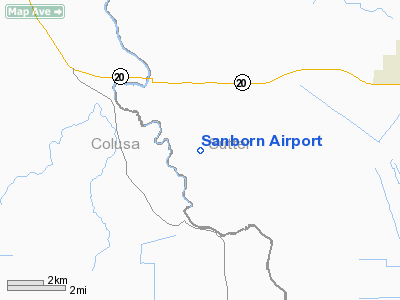
Sanborn Airport
Address:
Sutter County, CA
Tel:
916-696-2221
Images
and information placed above are from
http://www.airport-data.com/airport/38CN/
We
thank them for the data!
| General
Info |
| Country |
United
States |
| State |
CALIFORNIA
|
| FAA ID |
38CN
|
| Latitude |
39-06-33.614N
|
| Longitude |
121-53-01.893W
|
| Elevation |
36 feet
|
| Near City |
MERIDIAN
|
We don't guarantee the information is fresh and accurate. The data may
be wrong or outdated.
For more up-to-date information please refer to other sources.
|
|


