 |
|
|
|
|
|
Location
& QuickFacts
|
FAA
Information Effective: |
2006-09-28 |
|
Airport
Identifier: |
CA35 |
|
Longitude/Latitude: |
122-31-14.9140W/38-01-00.7190N
-122.520809/38.016866 (Estimated) |
|
Elevation: |
5 ft / 1.52 m (Estimated) |
|
Land: |
100 acres |
|
From
nearest city: |
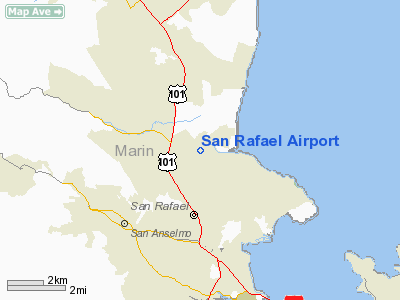
3 nautical miles N of San Rafael, CA |
|
Location: |
Marin County, CA |
|
Magnetic Variation: |
16E (1985) |
Owner
& Manager
|
Ownership: |
Privately owned |
|
Owner: |
Marin Ranch Airport Inc. |
|
Address: |
2173 D Francisco Blvd
San Rafael, CA 94901 |
|
Phone
number: |
415-453-0212 |
|
Manager: |
Len Nibbi |
|
Address: |
2173 D Francisco Blvd
San Rafael, CA 94901 |
|
Phone
number: |
415-897-2964
PHONE NUMBER AT ARPT 415-472-0227 - FBO. |
Airport
Operations and Facilities
|
Airport Use: |
Private |
|
Wind indicator: |
Yes |
|
Segmented Circle: |
Yes |
|
Control Tower: |
No |
|
Attendance Schedule: |
ALL/ALL/DALGT |
|
Lighting Schedule: |
DUSK-DAWN |
|
Landing fee charge: |
Yes |
|
Sectional chart: |
San Francisco |
|
Region: |
AWP - Western-Pacific |
|
Traffic Pattern Alt: |
1000 ft |
|
Boundary ARTCC: |
ZOA - Oakland |
|
Tie-in FSS: |
OAK - Oakland |
|
FSS on Airport: |
No |
|
FSS Phone: |
510-273-6111 |
|
FSS Toll Free: |
1-800-WX-BRIEF |
Airport
Communications
Airport
Services
|
Fuel
available: |
100LLA
FOR FUEL CALL 415-897-2964. |
|
Airframe
Repair: |
MAJOR |
|
Power
Plant Repair: |
MAJOR |
|
Bottled
Oxygen: |
NONE |
|
Bulk
Oxygen: |
NONE |
|
Runway Information
Runway 04/22
|
Dimension: |
2140 x 30 ft / 652.3 x 9.1 m |
|
Surface: |
ASPH, Fair Condition |
|
Weight
Limit: |
Single wheel: 7000 lbs. |
|
Edge
Lights: |
Low
FAA APPROVED STD FIXTURES & THR LGTS; EACH SIDE THR. |
|
|
Runway 04 |
Runway 22 |
|
Traffic
Pattern: |
Left |
Right |
|
Markings: |
Nonstandard, Fair Condition |
, |
|
Runway
End Identifier: |
No |
No |
|
Centerline
Lights: |
No |
No |
|
Touchdown
Lights: |
No |
No |
|
Obstruction: |
300 ft hill, 4500.0 ft from runway, 14:1 slope
to clear |
40 ft pole, 1150.0 ft from runway, 24:1 slope
to clear |
|
Radio Navigation
Aids
|
ID |
Type |
Name |
Ch |
Freq |
Var |
Dist |
|
LV |
NDB |
Reiga |
|
374.00 |
16E |
44.2 nm |
|
SUU |
TACAN |
Travis |
113X |
|
17E |
30.5 nm |
|
NUQ |
TACAN |
Moffett |
123X |
|
17E |
41.5 nm |
|
TZZ |
VOR |
Travis |
|
116.40 |
17E |
38.9 nm |
|
CCR |
VOR/DME |
Concord |
117X |
117.00 |
17E |
22.6 nm |
|
SFO |
VOR/DME |
San Francisco |
105X |
115.80 |
17E |
24.9 nm |
|
STS |
VOR/DME |
Santa Rosa |
077X |
113.00 |
16E |
32.5 nm |
|
SJC |
VOR/DME |
San Jose |
088X |
114.10 |
16E |
47.3 nm |
|
SAU |
VORTAC |
Sausalito |
109X |
116.20 |
17E |
9.7 nm |
|
SGD |
VORTAC |
Scaggs Island |
058X |
112.10 |
17E |
12.0 nm |
|
PYE |
VORTAC |
Point Reyes |
084X |
113.70 |
17E |
16.9 nm |
|
OAK |
VORTAC |
Oakland |
115X |
116.80 |
17E |
22.5 nm |
|
OSI |
VORTAC |
Woodside |
086X |
113.90 |
17E |
39.2 nm |
|
SFO |
VOT |
San Francisco Intl |
|
111.00 |
|
24.9 nm |
Remarks
Based Aircraft
|
Aircraft
based on field: |
100 |
|
Single
Engine Airplanes: |
100 |
Operational Statistics
|
Aircraft
Operations: |
174/Week |
|
General
Aviation Local: |
88.9% |
|
General
Aviation Itinerant: |
11.1% |
San Rafael Airport
Address:
Marin County, CA
Tel:
415-453-0212,
415-897-2964
Images
and information placed above are from
http://www.airport-data.com/airport/CA35/
We
thank them for the data!
| General
Info |
| Country |
United
States |
| State |
CALIFORNIA
|
| FAA ID |
CA35
|
| Latitude |
38-01-00.719N
|
| Longitude |
122-31-14.914W
|
| Elevation |
5 feet
|
| Near City |
SAN RAFAEL
|
We don't guarantee the information is fresh and accurate. The data may
be wrong or outdated.
For more up-to-date information please refer to other sources.
|
|


