|
|
San Luis County Regional Airport |
San Luis Obispo County Regional Airport
McChesney Field |
| IATA: SBP – ICAO: KSBP – FAA LID: SBP |
| Summary |
| Airport type |
Public |
| Operator |
San Luis Obispo County |
| Location |
San Luis Obispo, California |
| Elevation AMSL |
212 ft / 64.5 m |
| Coordinates |
35°14′13″N 120°38′31″W / 35.23694°N 120.64194°W / 35.23694; -120.64194Coordinates: 35°14′13″N 120°38′31″W / 35.23694°N 120.64194°W / 35.23694; -120.64194 |
| Website |
www.sloairport.com |
| Runways |
| Direction |
Length |
Surface |
| ft |
m |
| 11/29 |
6,100 |
1,859 |
Asphalt |
| 7/25 |
2,500 |
762 |
Asphalt |
San Luis Obispo County Regional Airport (IATA: SBP, ICAO: KSBP, FAA LID: SBP), also known as McChesney Field, is an airport located in San Luis Obispo, California serving San Luis Obispo County. The airport is mostly used for general aviation, but is also served by two commercial airlines.
Located just south of the City of San Luis Obispo, the San Luis Obispo County Regional Airport serves areas as far north as Southern Monterey County and as far south as Northern Santa Barbara County. The airport offers convenient access to and from the Central Coast. Residents and visitors have the choice of two commercial airlines with flights to Los Angeles, Phoenix, and San Francisco. The airport is also home to full service general aviation and corporate facilities. History
The San Luis Obispo County Regional Airport began as one man's dream. Earl Thomson, along with his brothers-in-law, William "Chris" and David Hoover, talked county officials into leasing them the land. By April 1939 the airport opened with an 88-by-100 foot hangar and dirt runways.
In 1940, hard surface runways and lights were installed by the War Department. In 1940 and 1941, 183 private pilots and 20 advanced students were trained here though a federally sponsored Civilian Pilot Training Program for armed services fliers.
The federal government took over the airport though World War II, turning it back to the county in 1946. Southwest Airways inaugurated a passenger and airline service that year.
In 1947, county supervisors contracted for another hangar, ramp, and eventually an administration building. The supervisors named Chris Hoover full-time airport manager in 1953.
In 1987, the San Luis Obispo County Regional Airport was dedicated as McChesney Field, in honor of Leroy E. McChesney for his leadership and dedication to aviation. Mr. McChesney resided in the county since 1920 and had been a pilot since 1949. He was a longtime member of the California Aviation Council, a member of the California Aeronautics Board, and other aviation organizations. Mr. McChesney was the Grand Marschal of the first Airport Day in 1984.
Airport facilities now include a terminal building, restaurant, numerous hangars and airplane related businesses. In 1988, a control tower was opened by the Federal Aviation Administration.
Although Southwest Airways started airline service here in 1946, it only lasted until 1955. Southwest replaced its DC-3's with Martin 404's, which were too large for the 4,000-foot (1,200 m) runway, so they moved to Paso Robles. There was a long gap in air passenger service until Swift Aire Lines was started up in 1969. By the time that the control tower opened in 1988, SkyWest Airlines, WestAir, and Wings West (later merged into American Eagle) were in operation. Passenger service from San Luis Obispo was here to stay. Today, two regional airlines serve the community: United Express (SkyWest Airlines) and U.S. Airways Express (Mesa Airlines).
Current operations
- From April 1 to the 4th, 2009, Boeing 737-700 and Airbus A319 charter aircraft from Alaska Airlines and Frontier Airlines arrived at the San Luis Obispo County Regional Airport with troops from the Oregon National Guard. With a longer wingspan and heavier weight than the Boeing 737, the Airbus A319 is currently the largest aircraft to land at San Luis Obispo Airport. Southwest Airlines 737 aircraft have also recently landed at San Luis Obispo Airport as part of military charter operations.
- On January 23, 2009 an Alaska Airlines 737-400 arrived at San Luis Airport from Chico, California. This was the largest aircraft ever to land at the airport at that time. The flight was carrying 125 passengers who were members of the San Francisco Symphony arriving to perform at Cal Poly's Performing Arts Center.
- On August 27, 2008 US Airways Express (Mesa Airlines) announced an expansion of service to San Luis Obispo Airport. Beginning October 2, 2008, flights to and from Phoenix will utilize the Bombardier Canadair Regional Jet 900 series (CRJ-900) as opposed the 200 series offering 36 more seats for its twice-daily flight.
Future expansion plans
The key components of the future expansion concept include:
- A 1,000-foot (+/-) pavement extension on the northwest end of Runway 11-29, providing a total runway pavement length of 6,300 feet (1,900 m).
- Install EMAS at the south end of Runway 11-29 to meet the current RSA requirement for a C-II runway.
- Extension of parallel Taxiways A and M to the northwest end of the extended runway, at the existing separation distances from the runway centerline.
- Straightening of Taxiway A at the current terminal ramp. Upon relocation of passenger terminal facilities to the new terminal, the portion of Taxiway A in front of the existing terminal may be aligned with the remainder of the taxiway.
- Other taxiway improvements include the extension of Taxiway C to the west ramp, closing of Taxiway E and replacement with a rightangled taxiway between Taxiway A and Taxiway J, and reconfiguration of Taxiway F. Taxiway J will be widened next to the west ramp to provide two-way taxiing.
- A new passenger terminal, ramp, and structured parking deck will be constructed in the location originally recommended in the 1998 Airport Master Plan. The new 66,350-square-foot (6,164 m) terminal is designed to meet increased space needs for post 9-11 security requirements (including inline bag screening) and future passenger demands in a phased manner, with additional building and concourse added as required to meet long term needs.
- A new Aircraft Rescue and Firefighting (ARFF) station is under construction to the southeast of the future terminal building. The new structure will be approximately 8,700 square feet (810 m).
- Shifting of the Runway 25 threshold, creating an interim length of 2,500 feet (760 m) on Runway 7-25. In addition, consistent with the runway’s B-I design category, the runway may be narrowed to 60 feet (18 m). Upon completion of the relocation of Santa Fe Road, the runway pavement may be extended 500 feet (150 m) on the west end to provide an ultimate runway length of 3,000 feet (910 m). Additional exit taxiways have been placed on either side of the runway.
- Upon completion of the westerly shift of the threshold of Runway 25, new general aviation fixed base operations facilities may be constructed southeast of the new passenger terminal ramp and ARFF facility. The facilities may include large span hangars (a minimum of 24,000 square feet), office area, ramp for itinerant aircraft, and automobile parking. An entrance/exit point onto Highway 227 may be provided near these facilities.
- Hangar facilities totaling 82,000 square feet (+/-) for general aviation aircraft southeast of the fixed base facilities. These facilities will provide 65 (+/-) individual storage units on the east side of the airfield. Parking ramp will also be provided southeast of the hangars. The hangars will be located outside of the primary surface area for Runway 11-29 (500 feet from runway centerline).
- Lease parcels along the south side of Runway 7-25 will provide for potential construction of 120,000 square feet (11,000 m) of individual hangars, with access from Buckley Road.
- In November 2009 the San Luis Jet Center will begin construction on their new 52,000 square foot, state of the art jet center and maintenance facility.
Facilities
San Luis Obispo County Regional Airport covers 340 acres (138 ha) and has two runways:
- Runway 11/29: 6,100 x 150 ft (1,859 x 46 m), Surface: Asphalt
- Runway 7/25: 2,500 x 100 ft (762 x 30 m), Surface: Asphalt
Fixed base operators
- Aviation Consultants Incorporated
- San Luis Jet Center
- Pigs Can Fly Aviation
- Pacific Aerocademy
- Air San Luis
Airlines and destinations
| Airlines |
Destinations |
| United Express operated by SkyWest Airlines |
Los Angeles, San Francisco |
| US Airways Express operated by Mesa Airlines |
Phoenix |
Cargo airlines
- ABX Air
- Ameriflight
- FedEx Express
- UPS Airlines
- West Air
Incidents and accidents
- January 8, 2009 - A Beechcraft Bonanza (BE36-A36) landed with its gear up causing runway 29/11 to be closed for approximately one hour. The pilot was the only person aboard and was not injured. The runway closure caused a SkyWest flight from San Francisco to divert to Southern California.
- March 17, 2009 - At 3:00pm, a Piper Comanche (PA-24) missed the runway upon landing, apparently catching a wind gust. The wind caused the plane to veer off the runway, down a grass side embankment and through a fence. The incident caused the runway to be closed for 10 to 15 minutes but no planes were delayed. The single occupant of the plane, the pilot, was not injured.
- August 24, 1984 - Wings West Airlines / Flight 628 Midair collision. Shortly after departing the San Luis Obispo County Regional Airport on a commuter flight to San Francisco International Airport, a Wings West Airlines twin-engine Beechcraft C99 (N6399U) collided head-on with a private Rockwell Commander 112TC aircraft (N112SM) that was descending for a landing at the same airport.
The above content comes from Wikipedia and is published under free licenses – click here to read more.
|
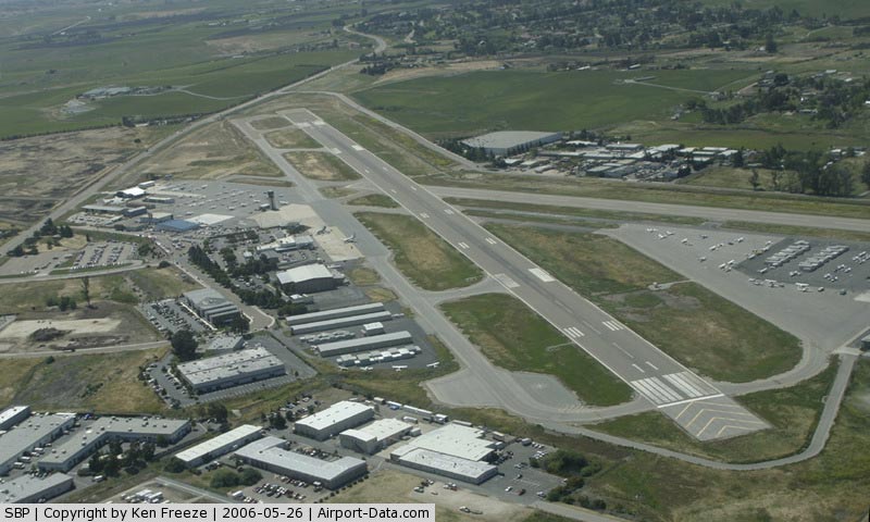
 |
(Click on the photo to enlarge) |
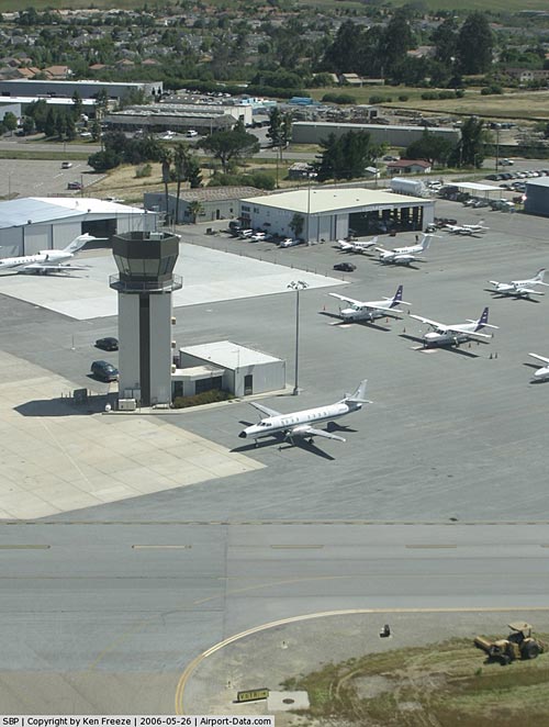
|
 |
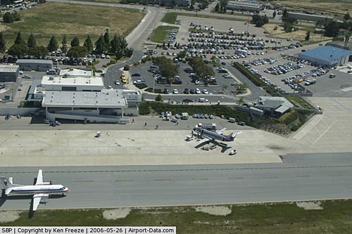
(Click on the photo to enlarge) |
|
 |
(Click on the photo to enlarge) |
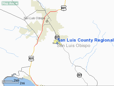
Location
& QuickFacts
|
FAA
Information Effective: |
2006-09-28 |
|
Airport
Identifier: |
SBP |
|
Longitude/Latitude: |
120-38-30.7000W/35-14-12.6000N
-120.641861/35.236833 (Estimated) |
|
Elevation: |
212 ft / 64.62 m (Surveyed) |
|
Land: |
340 acres |
|
From
nearest city: |
3 nautical miles S of San Luis Obispo, CA |
|
Location: |
San Luis Obispo County, CA |
|
Magnetic Variation: |
15E (1985) |
Owner
& Manager
|
Ownership: |
Publicly owned |
|
Owner: |
San Luis Obispo County |
|
Address: |
County Government Center
San Luis Obispo, CA 93408 |
|
Phone
number: |
805-781-5200 |
|
Manager: |
Klaasje Nairne |
|
Address: |
903-5 Airport Drive
San Luis Obispo, CA 93401 |
|
Phone number: |
805-781-5205 |
Airport
Operations and Facilities
|
Airport
Use: |
Open to public |
|
Wind
indicator: |
Yes |
|
Segmented
Circle: |
Yes |
|
Control
Tower: |
Yes |
|
Attendance
Schedule: |
ALL/ALL/0600-1700 |
|
Lighting
Schedule: |
DUSK-DAWN
WHEN ATCT CLSD ACTVT MALSR - CTAF. |
|
Beacon
Color: |
Clear-Green (lighted land airport) |
|
Landing
fee charge: |
No |
|
Sectional
chart: |
Los Angeles |
|
Region: |
AWP - Western-Pacific |
|
Traffic
Pattern Alt: |
1000 ft |
|
Boundary
ARTCC: |
ZLA - Los Angeles |
|
Tie-in
FSS: |
HHR - Hawthorne |
|
FSS
on Airport: |
No |
|
FSS
Phone: |
310-970-0102 |
|
FSS
Toll Free: |
1-800-WX-BRIEF |
|
NOTAMs
Facility: |
SBP (NOTAM-d service avaliable) |
|
Certification type/date: |
I AS 2/1980 |
|
Federal Agreements: |
NGY |
Airport
Communications
|
CTAF: |
124.000 |
|
Unicom: |
122.950 |
Airport
Services
|
Fuel
available: |
100LLA |
|
Airframe
Repair: |
MAJOR |
|
Power
Plant Repair: |
MAJOR |
|
Bottled
Oxygen: |
HIGH/LOW
REFIL CUSTOMER BOTTLE. |
|
Bulk
Oxygen: |
HIGH |
|
Runway Information
Runway 07/25
|
Dimension: |
3260 x 100 ft / 993.6 x 30.5 m |
|
Surface: |
ASPH, Fair Condition |
|
Weight
Limit: |
Single wheel: 12500 lbs.
Dual wheel: 12500 lbs. |
|
|
Runway 07 |
Runway 25 |
|
Longitude: |
120-39-00.9476W |
120-38-21.6502W |
|
Latitude: |
35-14-12.6760N |
35-14-12.7998N |
|
Elevation: |
162.00 ft |
197.00 ft |
|
Alignment: |
90 |
127 |
|
Traffic
Pattern: |
Left |
Left |
|
Markings: |
Basic, Good Condition |
Basic, Good Condition |
|
Runway
End Identifier: |
No |
No |
|
Centerline
Lights: |
No |
No |
|
Touchdown
Lights: |
No |
No |
|
Obstruction: |
10 ft road, 410.0 ft from runway, 21:1 slope
to clear |
, 50:1 slope to clear |
|
Runway 11/29
|
Dimension: |
5300 x 150 ft / 1615.4 x 45.7 m |
|
Surface: |
ASPH, Good Condition |
|
Surface
Treatment: |
Saw-cut or plastic Grooved |
|
Weight
Limit: |
Single wheel: 50000 lbs.
Dual wheel: 65000 lbs. |
|
Edge
Lights: |
High |
|
|
Runway 11 |
Runway 29 |
|
Longitude: |
120-38-50.4947W |
120-37-58.0073W |
|
Latitude: |
35-14-27.4344N |
35-13-57.5450N |
|
Elevation: |
166.00 ft |
212.00 ft |
|
Alignment: |
125 |
127 |
|
ILS
Type: |
ILS |
|
|
Traffic
Pattern: |
Left |
Left |
|
Markings: |
Precision instrument, Good Condition |
Non-precision instrument, Good Condition |
|
Crossing
Height: |
50.00 ft |
50.00 ft |
|
Displaced
threshold: |
0.00
ft |
500.00 ft |
|
VASI: |
4-box on left side |
4-box on left side |
|
Visual
Glide Angle: |
3.00� |
3.25� |
|
Approach
lights: |
MALSR |
|
|
Runway
End Identifier: |
No |
Yes |
|
Centerline
Lights: |
No |
No |
|
Touchdown
Lights: |
No |
No |
|
Radio Navigation
Aids
|
ID |
Type |
Name |
Ch |
Freq |
Var |
Dist |
|
VBG |
TACAN |
Vandenberg |
059Y |
|
15E |
30.5 nm |
|
GLJ |
VOR |
Guadalupe |
|
111.00 |
16E |
18.1 nm |
|
MQO |
VORTAC |
Morro Bay |
071X |
112.40 |
16E |
5.9 nm |
|
PRB |
VORTAC |
Paso Robles |
090X |
114.30 |
16E |
26.2 nm |
|
FLW |
VORTAC |
Fellows |
122X |
117.50 |
16E |
39.1 nm |
|
AVE |
VORTAC |
Avenal |
118X |
117.10 |
16E |
40.8 nm |
Remarks
- RECURRING
FLOCKS OF WATERFOWL ON AND IN VICINITY OF ARPT DURG WINTER MONTHS.
- TAXILANE
WIDTHS LESS THAN STANDARD.
- NOISE
SENSITIVE ARPT; TCH 50 FT; FOR NOISE ABATEMENT INFO CTC AMGR (805) 781-5205.
- RY
29 DESIGNATED CALM WIND RY.
- ATCT
UNABLE TO SEE ACFT IN HOLDING BAY AT NW END OF TWY A. MOVEMENT FM HOLDING
BAY REQUIRES ATCT APVL DURG ATCT HRS.
- PRIOR
TO 15 MAY 1959.
Based Aircraft
|
Aircraft
based on field: |
301 |
|
Single
Engine Airplanes: |
241 |
|
Multi
Engine Airplanes: |
45 |
|
Jet Engine
Airplanes: |
10 |
|
Helicopters: |
5 |
Major Carriers
Serving This Airport
| Sky West Airlines |
60.0% |
| American Eagle Airlines |
40.0% |
Most Popular Destinations
| Los Angeles Intl (LAX) |
73.3% |
| San Francisco Intl (SFO) |
26.7% |
Most Popular Aircraft
|
N301YV |
3.4% |
| N389AE |
3.3% |
|
N295UX |
3.1% |
| N396AE |
3.1% |
|
N390AE |
3.1% |
| N392AE |
3.0% |
|
N901AE |
2.9% |
| N393AE |
2.9% |
|
N394AE |
2.8% |
| N370AM |
2.5% |
Operational Statistics
|
Aircraft
Operations: |
337/Day |
|
Air Taxi: |
22.3% |
|
General
Aviation Local: |
36.8% |
|
General
Aviation Itinerant: |
40.2% |
|
Military: |
0.7% |
San Luis County Regional Airport
Address:
San Luis Obispo County, CA
Tel:
805-781-5200,
805-781-5205
Images
and information placed above are from
http://www.airport-data.com/airport/SBP/
We
thank them for the data!
| General
Info |
| Country |
United
States |
| State |
CALIFORNIA
|
| FAA ID |
SBP
|
| Latitude |
35-14-12.570N
|
| Longitude |
120-38-30.729W
|
| Elevation |
209 feet
|
| Near City |
SAN LUIS
OBISPO |
We don't guarantee the information is fresh and accurate. The data may
be wrong or outdated.
For more up-to-date information please refer to other sources.
|
|