|
|
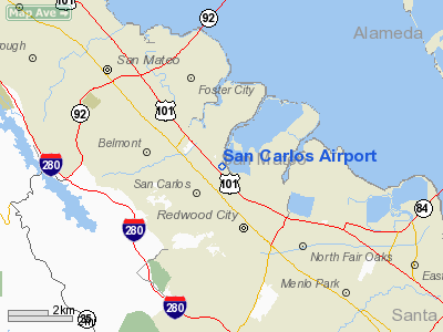
| San Carlos Airport |
 |
 |
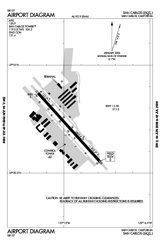
| FAA airport diagram |
| IATA: SQL – ICAO: KSQL – FAA LID: SQL |
| Summary |
| Airport type |
Public |
| Owner |
San Mateo County |
| Serves |
San Carlos, California |
| Elevation AMSL |
5 ft / 2 m |
| Coordinates |
37°30′43″N 122°14′58″W / 37.51194°N 122.24944°W / 37.51194; -122.24944Coordinates: 37°30′43″N 122°14′58″W / 37.51194°N 122.24944°W / 37.51194; -122.24944 |
| Runways |
| Direction |
Length |
Surface |
| ft |
m |
| 12/30 |
2,600 |
792 |
Asphalt |
| Statistics (2007) |
| Aircraft operations |
155,273 |
| Based aircraft |
372 |
| Source: Federal Aviation Administration |
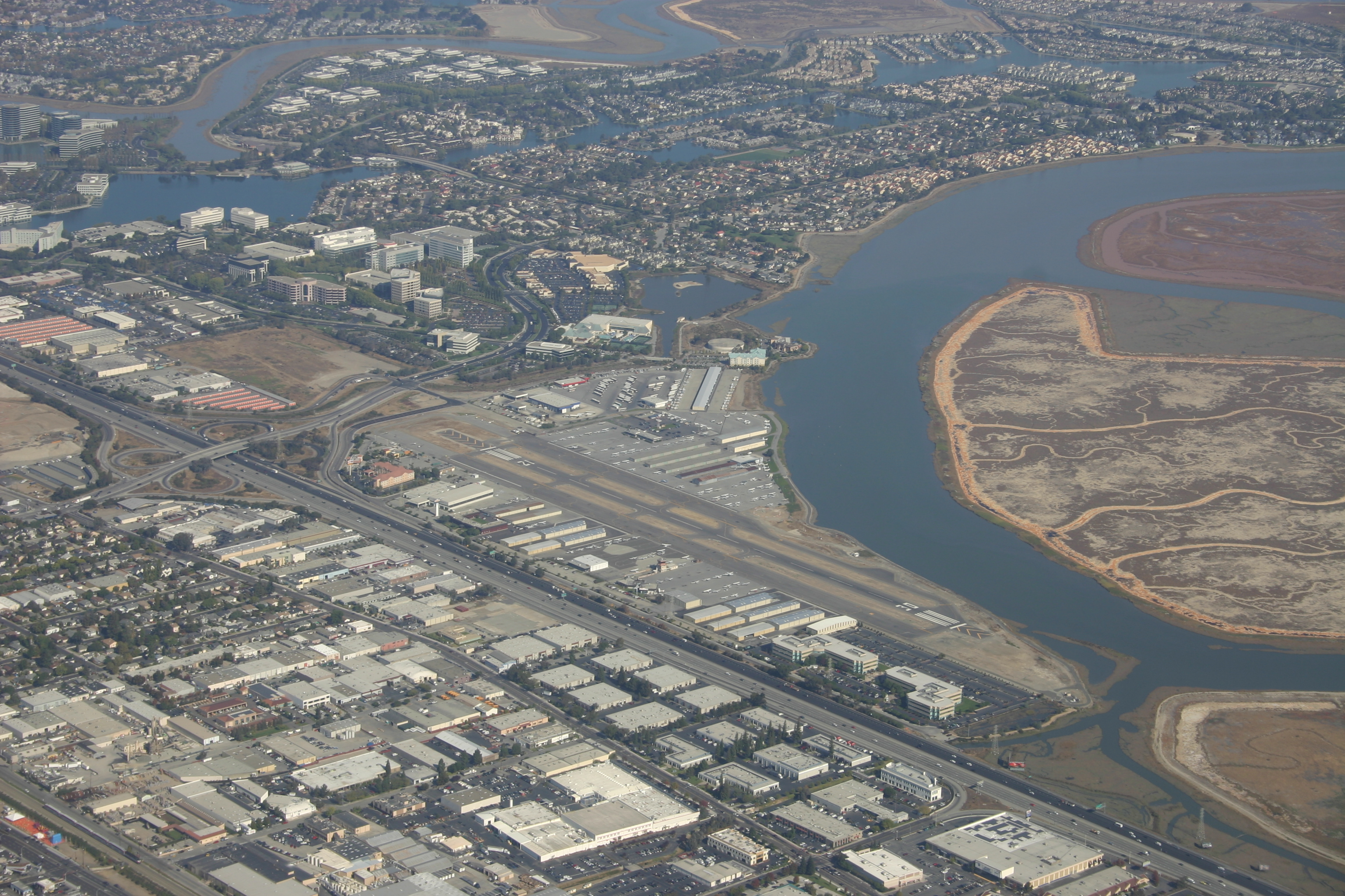
San Carlos Airport (IATA: SQL, ICAO: KSQL, FAA LID: SQL) is a county-owned public use airport in San Mateo County, California, United States. It is located two nautical miles (3.7 km) northeast of the central business district of San Carlos, California. The FAA's National Plan of Integrated Airport Systems (NPIAS) classifies San Carlos as a reliever airport for San Francisco International Airport.
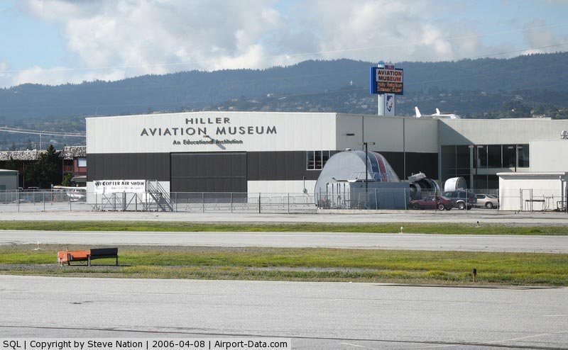
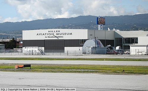
The airport is off U.S. Route 101. The airport is home to Civil Air Patrol West Bay Composite Squadron 192. Adjacent to the airport is the Hiller Air Museum. History
The San Carlos Airport was moved to its present location in 1950. Prior to that, the airport was located approximately one-half mile southwest of its current location at the site where a Best Buy is now located. This original San Carlos airport was opened by Frank S. Cooley prior to 1928.
Facilities and aircraft
San Carlos Airport covers an area of 110 acres (45 ha) at an elevation of 5 feet (2 m) above mean sea level. It has one asphalt paved runway designated 12/30 which measures 2,600 by 75 feet (792 x 23 m).
An attempt to lengthen the runway by 400 feet was quelled by neighbors in 1999. Aircraft with maximum gross weight in excess of 12,500 lb (5,670 kg) are prohibited from operating from San Carlos Airport.
The San Carlos Airport is home to over 30 aviation related businesses. Facilities and FBOs at KSQL include: Zanette Aviation Insurance, West Valley Flying Club, Bel-Air Aviation, Air West Aircraft Engines, and Diamond Aviation.
For the 12-month period ending December 31, 2007, the airport had 155,273 aircraft operations, an average of 425 per day: 98% general aviation, 2% air taxi and <1% military. At that time there were 372 aircraft based at this airport: 86% single-engine, 11% multi-engine, <1% jet and 3% helicopter.
Origin of SQL airport code
Given its proximity to the headquarters of the Oracle Corporation, a maker of database software, some have speculated that the airport code of SQL is a humorous reference to this large neighbor; in databases, SQL stands for Structured Query Language. It is just a coincidence, though one that many technically-inclined residents of the Bay Area and Silicon Valley were sure to notice. The airport was given this code well before the founding of the Oracle corporation.
The above content comes from Wikipedia and is published under free licenses – click here to read more.
|
 |
(Click on the photo to enlarge) |
Location
& QuickFacts
|
FAA
Information Effective: |
2006-09-28 |
|
Airport
Identifier: |
SQL |
|
Longitude/Latitude: |
122-14-58.2850W/37-30-42.6780N
-122.249524/37.511855 (Estimated) |
|
Elevation: |
5 ft / 1.52 m (Surveyed) |
|
Land: |
110 acres |
|
From
nearest city: |
2 nautical miles NE of San Carlos, CA |
|
Location: |
San Mateo County, CA |
|
Magnetic Variation: |
15E (2000) |
Owner
& Manager
|
Ownership: |
Publicly owned |
|
Owner: |
San Mateo County |
|
Address: |
555 County Center, 5th Floor
Redwood City, CA 94063-1665 |
|
Phone
number: |
650-573-3700
DIRECTOR OF PUBLIC WORKS - NEIL CULLEN. |
|
Manager: |
Mark Larson |
|
Address: |
620 Airport Dr
San Carlos, CA 94070 |
|
Phone number: |
650-573-3700 |
Airport
Operations and Facilities
|
Airport
Use: |
Open to public |
|
Wind
indicator: |
Yes |
|
Segmented
Circle: |
Yes |
|
Control
Tower: |
Yes |
|
Attendance
Schedule: |
ALL/ALL/0700-2300 |
|
Lighting
Schedule: |
DUSK-DAWN
WHEN ATCT CLSD; ACTVT MIRL RWY 12/30 & REIL RWY 30 -
119.0. |
|
Beacon
Color: |
Clear-Green (lighted land airport) |
|
Landing
fee charge: |
No |
|
Sectional
chart: |
San Francisco |
|
Region: |
AWP - Western-Pacific |
|
Traffic
Pattern Alt: |
800 ft |
|
Boundary
ARTCC: |
ZOA - Oakland |
|
Tie-in
FSS: |
OAK - Oakland |
|
FSS
on Airport: |
No |
|
FSS
Phone: |
510-273-6111 |
|
FSS
Toll Free: |
1-800-WX-BRIEF |
|
NOTAMs
Facility: |
SQL (NOTAM-d service avaliable) |
|
Federal Agreements: |
NGY |
Airport
Communications
|
CTAF: |
119.000 |
|
Unicom: |
122.950 |
Airport
Services
|
Fuel
available: |
100 100LLA |
|
Airframe
Repair: |
MAJOR |
|
Power
Plant Repair: |
MAJOR |
|
Bottled
Oxygen: |
HIGH/LOW |
|
Bulk
Oxygen: |
HIGH |
|
Runway Information
Runway 12/30
|
Dimension: |
2600 x 75 ft / 792.5 x 22.9 m |
|
Surface: |
ASPH, Good Condition |
|
Weight
Limit: |
Single wheel: 12500 lbs. |
|
Edge
Lights: |
Medium |
|
|
Runway 12 |
Runway 30 |
|
Longitude: |
122-15-09.0860W |
122-14-47.4840W |
|
Latitude: |
37-30-52.2250N |
37-30-33.1300N |
|
Elevation: |
5.00
ft |
5.00
ft |
|
Alignment: |
127 |
127 |
|
Traffic
Pattern: |
Left |
Right |
|
Markings: |
Basic, Good Condition |
Basic, Good Condition |
|
Crossing
Height: |
25.00 ft |
25.00 ft |
|
VASI: |
2-box on left side |
2-box on left side |
|
Visual
Glide Angle: |
3.00� |
3.00� |
|
Runway
End Identifier: |
Yes |
Yes |
|
Centerline
Lights: |
No |
No |
|
Touchdown
Lights: |
No |
No |
|
Obstruction: |
15 ft road, 600.0 ft from runway, 150 ft right
of centerline, 26:1 slope to clear |
7 ft levee, 200.0 ft from runway, 60 ft right
of centerline
7' LGTD DIKE 100' E OF CNTRLN AT THR, EXTENDING TO 60' E OF
CNTRLN AT END OF PRIMARY SFC. |
|
Radio Navigation
Aids
|
ID |
Type |
Name |
Ch |
Freq |
Var |
Dist |
|
LV |
NDB |
Reiga |
|
374.00 |
16E |
29.0 nm |
|
TCY |
NDB |
Tracy |
|
203.00 |
15E |
39.8 nm |
|
PDG |
NDB |
Pajar |
|
327.00 |
17E |
41.7 nm |
|
NUQ |
TACAN |
Moffett |
123X |
|
17E |
10.3 nm |
|
SUU |
TACAN |
Travis |
113X |
|
17E |
46.4 nm |
|
SFO |
VOR/DME |
San Francisco |
105X |
115.80 |
17E |
8.8 nm |
|
SJC |
VOR/DME |
San Jose |
088X |
114.10 |
16E |
16.7 nm |
|
CCR |
VOR/DME |
Concord |
117X |
117.00 |
17E |
33.5 nm |
|
OSI |
VORTAC |
Woodside |
086X |
113.90 |
17E |
7.3 nm |
|
OAK |
VORTAC |
Oakland |
115X |
116.80 |
17E |
12.9 nm |
|
SAU |
VORTAC |
Sausalito |
109X |
116.20 |
17E |
24.4 nm |
|
SGD |
VORTAC |
Scaggs Island |
058X |
112.10 |
17E |
40.5 nm |
|
PYE |
VORTAC |
Point Reyes |
084X |
113.70 |
17E |
45.0 nm |
|
SFO |
VOT |
San Francisco Intl |
|
111.00 |
|
8.8 nm |
Remarks
- FLD
CONDS-RWY GOOD, TWYS GOOD, APRON GOOD-FAIR, SOME SOFT SPOTS.
- NO
TGL WHEN TWR CLSD.
- CALM
WIND RY 12.
- NOISE
SENSITIVE AREAS S THRU NE OF ARPT. FOR NOISE ABATEMENT PROCEDURES CTC
AMGR (650) 573-3700.
- MIGRATORY
BIRD ACTIVITY ON & INVOF OF ARPT.
Based Aircraft
|
Aircraft
based on field: |
503 |
|
Single
Engine Airplanes: |
435 |
|
Multi
Engine Airplanes: |
60 |
|
Jet Engine
Airplanes: |
2 |
|
Helicopters: |
6 |
Operational Statistics
|
Aircraft
Operations: |
467/Day |
|
Air Taxi: |
2.1% |
|
General
Aviation Local: |
52.0% |
|
General
Aviation Itinerant: |
45.9% |
San Carlos Airport
Address:
San Mateo County, CA
Tel:
650-573-370
Images
and information placed above are from
http://www.airport-data.com/airport/SQL/
We
thank them for the data!
| General
Info |
| Country |
United
States |
| State |
CALIFORNIA
|
| FAA ID |
SQL
|
| Latitude |
37-30-42.678N
|
| Longitude |
122-14-58.285W
|
| Elevation |
5 feet
|
| Near City |
SAN CARLOS
|
We don't guarantee the information is fresh and accurate. The data may
be wrong or outdated.
For more up-to-date information please refer to other sources.
|
|