|
|
Sacramento Executive Airport |
| Sacramento Executive Airport |
 |
| IATA: SAC – ICAO: KSAC – FAA LID: SAC |
| Summary |
| Airport type |
Public |
| Operator |
Sacramento County |
| Location |
Sacramento, California |
| Elevation AMSL |
24 ft / 7.3 m |
| Coordinates |
38°30′45″N 121°29′36″W / 38.5125°N 121.49333°W / 38.5125; -121.49333Coordinates: 38°30′45″N 121°29′36″W / 38.5125°N 121.49333°W / 38.5125; -121.49333 |
| Runways |
| Direction |
Length |
Surface |
| ft |
m |
| 2/20 |
5,503 |
1,677 |
Asphalt |
| 12/30 |
3,836 |
1,169 |
Asphalt |
| 16/34 |
3,485 |
1,062 |
Asphalt |
| Helipads |
| Number |
Length |
Surface |
| ft |
m |
| H1 |
60 |
18 |
Asphalt |
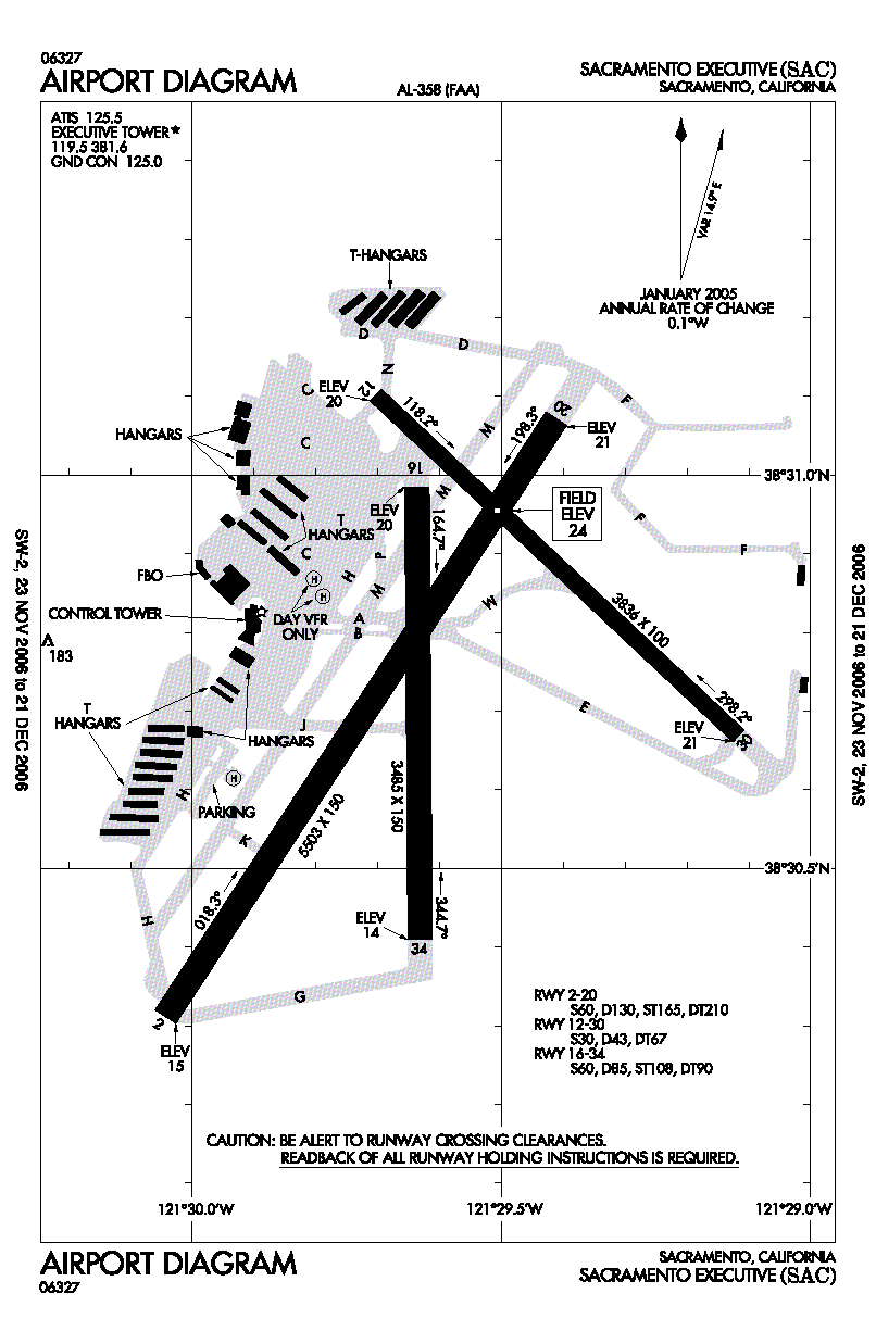
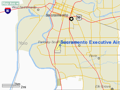
Sacramento Executive Airport (IATA: SAC, ICAO: KSAC, FAA LID: SAC), also known as simply Executive Airport, is a public airport located three miles (5 km) south of the central business district (CBD) of Sacramento, a city in Sacramento County, California, USA. The airport covers 540 acres (219 ha) and has three runways (two lighted) and one helipad.
History
When it opened in 1930, Executive Airport was originally known as Sutterville Aerodrome. As the city-owned facility continuously expanded, in 1941 construction was underway to pave and extend the airport's three runways.
The U.S. Army Air Corps took over the airport during World War II. After the war, control over the airport was returned to the city and the facility was officially renamed Sacramento Municipal Airport. During the late 1940s and early 1950s, improvements were made to parking and taxiway paving, water and sewer systems, and runway/taxiway lighting. The terminal building was constructed in 1955 along with some navigational aids and T-hangars.
In October 1967, commercial airline operations were moved to the newly opened Sacramento Metropolitan Airport and Sacramento Municipal Airport was renamed Sacramento Executive Airport. The County of Sacramento also became the operator of both airports at that time. Since then, Executive Airport has become Northern California's primary general aviation airport, offering a wide range of general aviation services.
Executive Airport has always been an important asset to the greater Sacramento area. Executive is self-supporting. It receives no city, county, or tax money. All operating expenses are paid for by the income it receives from businesses or individuals who use it.
1972 Farrell's Ice Cream Parlor Crash
On September 24, 1972, a retired Sabrejet N275X jet plane was set to perform air tricks at the Golden West Sport Aviation Show. Due to pilot error, the airplane failed to become airborne and crashed into Farrell's Ice Cream Parlor. The huge explosion killed 22 people, 12 of those children. The tragedy prompted closure of a runway to all aircraft, stricter regulations at the airport, and the opening of the Sacramento Firefighter's Burn Insitiute. The shopping center that housed the ice cream parlor was closed and rebuilt as the Sacramento Public Safety Center, which is the main center for the Sacramento Fire Department and Sacramento Police Department. A memorial was constructed at the crash site.
Facilities
Sacramento Executive Airport is a general aviation airport which offers many facilities and services. In addition to an FAA tower, the airport has three paved runways (two lighted) and offers tie-downs and hangar rentals.
Over 20 businesses are located at Executive, providing a wide range of services including: air charters; aircraft sales, rentals and repairs; flight training; pilot supplies; computer-based testing; and car rentals.
Located 10 minutes from downtown Sacramento, Executive is close to tourist attractions such as Old Sacramento, the State Capitol, Cal Expo State Fairgrounds and ARCO Arena (home of the Sacramento Kings). The airport is also located near three public golf courses and major shopping areas. Because of its location, it is easy to see why in 2004 the average amount of aircraft operations per day were 370.
Executive offers three runways and two of them are lighted: Runway 2/20 is 5,503 x 150 feet. A Medium Intensity Approach Light System with Runway Alignment Indicator Lights is installed on Runway 2. REIL and VASI are on Runway 20. The FAA contract control tower operates 0600-2100 (local).
Fuel is available from trucks or 24-hour self-serve credit card pumps and plenty of tie down and transient parking is available, the first six hours of which are free. There is plenty of automobile parking in front of the terminal and is also free for the first 72 hours.
Amenities
Amenities at Sacramento Executive Airport include:
- Pilot's Lounge
- SACjet terminal with available meeting rooms
- Executive Airport terminal with available meeting rooms
- Disabled access, accommodations, and services throughout the facilities
- Restaurant in the terminal building
- Self-serve 100 LL Avgas, Jet A, tie-downs, hangar space, FBO and line services
- Contract control tower 6 a.m. to 9 p.m. daily (SERCO)
- Free, short-term (72-hour) auto parking
Restaurants
Serving breakfast, lunch, and dinner, Aviators overlooks the airfield and can hold up to 190 people. They are available for banquet use and other events.
The above content comes from Wikipedia and is published under free licenses – click here to read more.
Location
& QuickFacts
|
FAA
Information Effective: |
2006-09-28 |
|
Airport
Identifier: |
SAC |
|
Longitude/Latitude: |
121-29-36.5000W/38-30-45.1000N
-121.493472/38.512528 (Estimated) |
|
Elevation: |
24 ft / 7.32 m (Surveyed) |
|
Land: |
540 acres |
|
From
nearest city: |
3 nautical miles S of Sacramento, CA |
|
Location: |
Sacramento County, CA |
|
Magnetic Variation: |
16E (1985) |
Owner
& Manager
|
Ownership: |
Publicly owned |
|
Owner: |
City Of Sacramento
OPERD BY CO OF SACRAMENTO, THOMAS P. ENGEL, DIR OF ARPTS. |
|
Address: |
6151 Freeport Blvd.
Sacramento, CA 95322-3518 |
|
Phone
number: |
916-929-5411 |
|
Manager: |
John Downey
OPERATED BY CO OF SACRAMENTO - G. HARDY ACREE. |
|
Address: |
6151 Freeport Blvd
Sacramento, CA 95822 |
|
Phone
number: |
916-875-9035
APT MGR HRS 0800-1630 M-F |
Airport
Operations and Facilities
|
Airport
Use: |
Open to public |
|
Wind
indicator: |
Yes |
|
Segmented
Circle: |
Yes |
|
Control
Tower: |
Yes |
|
Attendance
Schedule: |
ALL/ALL/0600-2100 |
|
Lighting
Schedule: |
DUSK-DAWN
WHEN ATCT CLSD ACTVT ALL AIRFIELD LGTS - CTAF.
VASI
RY 20 OPER CONT. |
|
Beacon
Color: |
Clear-Green (lighted land airport) |
|
Landing
fee charge: |
No |
|
Sectional
chart: |
San Francisco |
|
Region: |
AWP - Western-Pacific |
|
Boundary
ARTCC: |
ZOA - Oakland |
|
Tie-in
FSS: |
RIU - Rancho Murieta |
|
FSS
on Airport: |
No |
|
FSS
Phone: |
916-354-0161 |
|
FSS
Toll Free: |
1-800-WX-BRIEF |
|
NOTAMs
Facility: |
SAC (NOTAM-d service avaliable) |
|
Federal Agreements: |
NGPY3 |
Airport
Communications
|
CTAF: |
119.500 |
|
Unicom: |
122.950 |
Airport
Services
|
Fuel
available: |
100LLA |
|
Airframe
Repair: |
MAJOR |
|
Power
Plant Repair: |
MAJOR |
|
Bottled
Oxygen: |
HIGH/LOW |
|
Bulk
Oxygen: |
HIGH/LOW |
|
Runway Information
Runway 02/20
|
Dimension: |
5503 x 150 ft / 1677.3 x 45.7 m |
|
Surface: |
ASPH, Good Condition |
|
Weight
Limit: |
Single wheel: 60000 lbs.
Dual wheel: 130000 lbs.
Dual
tandem wheel: 210000 lbs. |
|
Edge
Lights: |
Medium |
|
|
Runway 02 |
Runway 20 |
|
Longitude: |
121-30-02.6188W |
121-29-24.7989W |
|
Latitude: |
38-30-18.7201N |
38-31-04.2796N |
|
Elevation: |
18.00
ft |
24.00 ft |
|
Alignment: |
33 |
127 |
|
ILS
Type: |
ILS |
|
|
Traffic
Pattern: |
Left |
Left |
|
Markings: |
Precision instrument, Good Condition |
Precision instrument, Good Condition |
|
Crossing
Height: |
0.00
ft |
52.00 ft |
|
VASI: |
|
4-box on left side |
|
Visual
Glide Angle: |
0.00� |
3.00� |
|
Approach
lights: |
MALSR |
|
|
Runway
End Identifier: |
No |
Yes |
|
Centerline
Lights: |
No |
No |
|
Touchdown
Lights: |
No |
No |
|
Obstruction: |
33 ft tree, 1350.0 ft from runway, 275L/ ft
right of centerline, 34:1 slope to clear |
40 ft tree, 1430.0 ft from runway, 250 ft right
of centerline, 30:1 slope to clear |
|
Runway 12/30
|
Dimension: |
3836 x 100 ft / 1169.2 x 30.5 m |
|
Surface: |
ASPH, Good Condition |
|
Weight
Limit: |
Single wheel: 30000 lbs.
Dual wheel: 43000 lbs.
Dual
tandem wheel: 67000 lbs. |
|
Edge
Lights: |
Medium |
|
|
Runway 12 |
Runway 30 |
|
Longitude: |
121-29-42.2586W |
121-29-07.0350W |
|
Latitude: |
38-31-06.0732N |
38-30-40.1550N |
|
Elevation: |
23.00
ft |
24.00 ft |
|
Alignment: |
127 |
127 |
|
Traffic
Pattern: |
Left |
Left |
|
Markings: |
Basic, Good Condition |
Basic, Good Condition |
|
Crossing
Height: |
58.00 ft |
26.00 ft |
|
VASI: |
2-box on left side |
2-box on left side |
|
Visual
Glide Angle: |
3.00� |
3.50� |
|
Runway
End Identifier: |
Yes |
Yes |
|
Centerline
Lights: |
No |
No |
|
Touchdown
Lights: |
No |
No |
|
Obstruction: |
40 ft tree, 1200.0 ft from runway, 200 ft right
of centerline, 25:1 slope to clear |
50 ft tree, 1050.0 ft from runway, 100 ft left
of centerline, 17:1 slope to clear |
|
Runway 16/34
|
Dimension: |
3485 x 150 ft / 1062.2 x 45.7 m |
|
Surface: |
ASPH, Good Condition |
|
Weight
Limit: |
Single wheel: 60000 lbs.
Dual wheel: 85000 lbs.
Dual
tandem wheel: 90000 lbs. |
|
|
Runway 16 |
Runway 34 |
|
Longitude: |
121-29-38.2669W |
121-29-37.9731W |
|
Latitude: |
38-30-59.1355N |
38-30-24.6900N |
|
Elevation: |
22.00
ft |
17.00
ft |
|
Alignment: |
127 |
127 |
|
Traffic
Pattern: |
Left |
Left |
|
Markings: |
Basic, Fair Condition |
Basic, Fair Condition |
|
Runway
End Identifier: |
No |
No |
|
Centerline
Lights: |
No |
No |
|
Touchdown
Lights: |
No |
No |
|
Obstruction: |
50 ft tree, 1680.0 ft from runway, 200 ft right
of centerline, 29:1 slope to clear |
62 ft tree, 1400.0 ft from runway, 150 ft right
of centerline, 19:1 slope to clear |
|
Helipad H1
|
Dimension: |
60 x 60 ft / 18.3 x 18.3 m |
|
Surface: |
ASPH, Good Condition |
|
|
Runway H1 |
Runway |
|
Traffic
Pattern: |
Left |
Left |
|
Radio Navigation
Aids
|
ID |
Type |
Name |
Ch |
Freq |
Var |
Dist |
|
MY |
NDB |
Halow |
|
222.00 |
16E |
39.9 nm |
|
TCY |
NDB |
Tracy |
|
203.00 |
15E |
49.4 nm |
|
SUU |
TACAN |
Travis |
113X |
|
17E |
26.7 nm |
|
BAB |
TACAN |
Beale |
023X |
|
16E |
37.5 nm |
|
TZZ |
VOR |
Travis |
|
116.40 |
17E |
18.0 nm |
|
MCC |
VOR/DME |
Mc Clellan |
029X |
109.20 |
17E |
10.2 nm |
|
MYV |
VOR/DME |
Marysville |
045X |
110.80 |
16E |
35.4 nm |
|
HNW |
VOR/DME |
Hangtown |
102X |
115.50 |
17E |
37.2 nm |
|
CCR |
VOR/DME |
Concord |
117X |
117.00 |
17E |
38.3 nm |
|
SAC |
VORTAC |
Sacramento |
099X |
115.20 |
17E |
5.0 nm |
|
LIN |
VORTAC |
Linden |
095X |
114.80 |
17E |
35.0 nm |
|
ILA |
VORTAC |
Williams |
091X |
114.40 |
18E |
41.9 nm |
|
ECA |
VORTAC |
Manteca |
107X |
116.00 |
17E |
43.6 nm |
|
SGD |
VORTAC |
Scaggs Island |
058X |
112.10 |
17E |
46.1 nm |
|
SAC |
VOT |
Sacramento Executive |
|
111.40 |
|
0.2 nm |
|
SMF |
VOT |
Sacramento Metropolitan |
|
111.40 |
|
11.6 nm |
Remarks
- RY
20 CALM WIND RY.
- RY
16 BLAST PAD FM RY 12/30 INTERSECTION TO NORTH HANGARS CLSD PERMLY TO
ACFT TAXI.
- NO
TOUCH & GO LNDGS, LOW APPCHS OR PRACTICE INST APPCHS BTN HRS 2100-0600
LOCAL; FOR MORE INFO CALL (916) 874-0359.
- APRT
RESTRICTED BY APRT OPER TO ACFT WITH MAX CERT TKOF WEIGHT OF 50,000
LBS OR LESS; CALL APRT OPNS (916) 875-9035 FOR MORE INFO.
- BIRDS
INVOF OF APRT.
- DITCH
AND CONCRETE BRIDGE IN RY 02/20 SAFETY AREA LCTD 500 FT PRIOR TO RY
02 THLD ON CL.
- ARPT
NOISE ABATEMENT PROCEDURES IN EFFECT 2100-0600 FOR MORE INFO CALL (916)
875-9037 OR (916) 875-9035.
- ARPT
24HR EMERGENCY 916-929-5000.
- GOLF
COURSE LGTS SHINE ACROSS RY 02 FINAL APCH 800 FT RY CL DUSK TO 2200.
- RY
16/34 CLSD TO JET ACFT.
- NO
MID-FIELD, INTERSECTION OR FORMATION TKOFS.
Based Aircraft
|
Aircraft
based on field: |
365 |
|
Single
Engine Airplanes: |
280 |
|
Multi
Engine Airplanes: |
70 |
|
Jet Engine
Airplanes: |
1 |
|
Helicopters: |
14 |
Operational Statistics
|
Aircraft
Operations: |
370/Day |
|
Air Taxi: |
10.9% |
|
General
Aviation Local: |
28.9% |
|
General
Aviation Itinerant: |
58.8% |
|
Military: |
1.5% |
Sacramento Executive Airport
Address:
Sacramento County, CA
Tel:
916-929-5411,
916-875-9035
Images
and information placed above are from
http://www.airport-data.com/airport/SAC/
We
thank them for the data!
| General
Info |
| Country |
United
States |
| State |
CALIFORNIA
|
| FAA ID |
SAC
|
| Latitude |
38-30-45.086N
|
| Longitude |
121-29-36.488W
|
| Elevation |
24 feet
|
| Near City |
SACRAMENTO
|
We don't guarantee the information is fresh and accurate. The data may
be wrong or outdated.
For more up-to-date information please refer to other sources.
|
|