 |
|
| Rohnerville Airport |
| IATA: none – ICAO: KFOT – FAA LID: FOT |
| Summary |
| Airport type |
Public |
| Owner |
Humboldt County |
| Location |
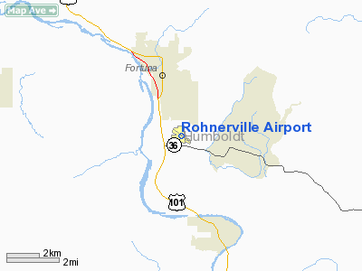
Fortuna, California |
| Elevation AMSL |
392 ft / 119 m |
| Coordinates |
40°33′14″N 124°07′58″W / 40.55389°N 124.13278°W / 40.55389; -124.13278 |
| Runways |
| Direction |
Length |
Surface |
| ft |
m |
| 11/29 |
4,005 |
1,221 |
Asphalt |
| Statistics (2004) |
| Aircraft operations |
27,500 |
| Based aircraft |
36 |
| Source: Federal Aviation Administration |
Rohnerville Airport (ICAO: KFOT, FAA LID: FOT) is a public airport located three miles (5 km) southeast of the central business district of Fortuna, a city in Humboldt County, California, United States. It is owned by the County of Humboldt.
Although most U.S. airports use the same three-letter location identifier for the FAA and IATA, Rohnerville Airport is assigned FOT by the FAA but has no designation from the IATA (which assigned FOT to Forster, New South Wales, Australia).
Facilities and aircraft
Rohnerville Airport covers an area of 541 acres (219 ha) which contains one asphalt paved runway (11/29) measuring 4,005 x 100 ft (1,221 x 30 m).
For the 12-month period ending October 27, 2004, the airport had 27,500 aircraft operations, an average of 75 per day, all of which were general aviation. There are 36 aircraft based at this airport: 86% single engine, 11% multi-engine and 3% helicopters.
The above content comes from Wikipedia and is published under free licenses – click here to read more.
Location
& QuickFacts
|
FAA
Information Effective: |
2006-09-28 |
|
Airport
Identifier: |
FOT |
|
Longitude/Latitude: |
124-07-57.5720W/40-33-14.1690N
-124.132659/40.553936 (Estimated) |
|
Elevation: |
392 ft / 119.48 m (Surveyed) |
|
Land: |
541 acres |
|
From
nearest city: |
3 nautical miles SE of Fortuna, CA |
|
Location: |
Humboldt County, CA |
|
Magnetic Variation: |
17E (2000) |
Owner
& Manager
|
Ownership: |
Publicly owned |
|
Owner: |
Humboldt County |
|
Address: |
1106 2nd St
Eureka, CA 95501 |
|
Phone
number: |
707-839-5401 |
|
Manager: |
Jacquelyn Hulsey
ARPT MANAGER LOCATED AT ARCATA/EUREKA AIRPORT. |
|
Address: |
3561 Boeing Ave.
Mckinleyville, CA 95519 |
|
Phone
number: |
707-839-5401
PHONE RINGS AT MGRS ARCATA OFFICE. |
Airport
Operations and Facilities
|
Airport
Use: |
Open to public |
|
Wind
indicator: |
Yes |
|
Segmented
Circle: |
Yes |
|
Control
Tower: |
No |
|
Attendance
Schedule: |
UNATNDD |
|
Lighting
Schedule: |
DUSK-DAWN
ACTVT MIRL RY 11/29 - CTAF. |
|
Beacon
Color: |
Clear-Green (lighted land airport) |
|
Landing
fee charge: |
No |
|
Sectional
chart: |
Klamath Falls |
|
Region: |
AWP - Western-Pacific |
|
Traffic
Pattern Alt: |
800 ft |
|
Boundary
ARTCC: |
ZSE - Seattle |
|
Tie-in
FSS: |
OAK - Oakland |
|
FSS
on Airport: |
No |
|
FSS
Phone: |
510-273-6111 |
|
FSS
Toll Free: |
1-800-WX-BRIEF |
|
NOTAMs
Facility: |
OAK (NOTAM-d service avaliable) |
|
Federal Agreements: |
NGY |
Airport
Communications
Airport
Services
|
Bottled
Oxygen: |
NONE |
|
Bulk
Oxygen: |
NONE |
|
Runway Information
Runway 11/29
|
Dimension: |
4005 x 100 ft / 1220.7 x 30.5 m |
|
Surface: |
ASPH, Good Condition |
|
Weight
Limit: |
Single wheel: 30000 lbs. |
|
Edge
Lights: |
Medium |
|
|
Runway 11 |
Runway 29 |
|
Longitude: |
124-08-18.1550W |
124-07-36.9910W |
|
Latitude: |
40-33-26.2140N |
40-33-02.1230N |
|
Elevation: |
340.00 ft |
392.00 ft |
|
Alignment: |
127 |
127 |
|
Traffic
Pattern: |
Right |
Left |
|
Markings: |
Non-precision instrument, Fair Condition |
Non-precision instrument, Fair Condition |
|
Crossing
Height: |
45.00 ft |
0.00
ft |
|
VASI: |
4-box on right side |
|
|
Visual
Glide Angle: |
3.00� |
0.00� |
|
Runway
End Identifier: |
Yes |
Yes
RY 29 REIL OTS INDEFLY. |
|
Radio Navigation
Aids
|
ID |
Type |
Name |
Ch |
Freq |
Var |
Dist |
|
ACV |
VOR/DME |
Arcata |
039X |
110.20 |
17E |
25.7 nm |
|
FOT |
VORTAC |
Fortuna |
087X |
114.00 |
19E |
8.4 nm |
Remarks
- USFS
AND CDF FIRE RETARDENT STATION.
- DEER
INVOF OF RYS.
- ESTABD
PRIOR TO 15 MAY 1959.
Based Aircraft
|
Aircraft
based on field: |
36 |
|
Single
Engine Airplanes: |
31 |
|
Multi
Engine Airplanes: |
4 |
|
Helicopters: |
1 |
Operational Statistics
|
Aircraft
Operations: |
76/Day |
|
General
Aviation Local: |
60.0% |
|
General
Aviation Itinerant: |
40.0% |
Rohnerville Airport
Address:
Humboldt County, CA
Tel:
707-839-5401
Images
and information placed above are from
http://www.airport-data.com/airport/FOT/
We
thank them for the data!
| General
Info |
| Country |
United
States |
| State |
CALIFORNIA
|
| FAA ID |
FOT
|
| Latitude |
40-33-14.169N
|
| Longitude |
124-07-57.572W
|
| Elevation |
392 feet
|
| Near City |
FORTUNA
|
We don't guarantee the information is fresh and accurate. The data may
be wrong or outdated.
For more up-to-date information please refer to other sources.
|
|


