|
|
Riverside Municipal Airport |
| Riverside Municipal Airport |
 |
| IATA: RAL – ICAO: KRAL – FAA LID: RAL |
| Summary |
| Airport type |
Public |
| Operator |
City of Riverside |
| Location |
Riverside, California |
| Elevation AMSL |
818 ft / 249 m |
| Coordinates |
33°57′07″N 117°26′42″W / 33.95194°N 117.445°W / 33.95194; -117.445Coordinates: 33°57′07″N 117°26′42″W / 33.95194°N 117.445°W / 33.95194; -117.445 |
| Runways |
| Direction |
Length |
Surface |
| ft |
m |
| 9/27 |
5,400 |
1,646 |
Asphalt |
| 16/34 |
2,850 |
869 |
Asphalt |
| Helipads |
| Number |
Length |
Surface |
| ft |
m |
| H1 |
60 |
18 |
Asphalt |
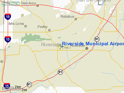
Riverside Municipal Airport (IATA: RAL, ICAO: KRAL, FAA LID: RAL), also known as Riverside Airport (and formerly as Riverside Arlington Airport), is a public airport located four miles (6 km) southwest of the central business district of Riverside, the county seat of Riverside County, California, United States. The airport is located in the Inland Empire, a region with a population of over four million people.
Scheduled service to Laughlin/Bullhead International Airport (Arizona) on Western Express Air was discontinued when that airline ceased operations at the end of May 2007.
Riverside Municipal Airport since 2003 has been the home to Civil Air Patrol Squadron 5, California's largest squadron. Meeting every Tuesday night at 1900L.
Facilities
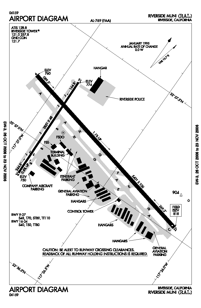
Riverside Municipal Airport covers 525 acres (212 ha) and has two runways and one helipad:
- Runway 9/27: 5,400 x 100 ft. (1,646 x 30 m), Surface: Asphalt
- Runway 16/34: 2,850 x 48 ft. (869 x 15 m), Surface: Asphalt
- Helipad H1: 60 x 60 ft. (18 x 18 m), Surface: Asphalt
Riverside Airport's full service runways feature ILS, GPS, and VOR approaches for all-weather arrivals and departures.
The main runway, RWY 9-27, accommodates Gulfstream V, Dassault Falcon 50, Bombardier Challenger, Cessna Citation X and similar business-class aircraft. The Airport's current Master Plan will lengthen this runway to 6,153 feet (1,875 m) in the near future. Runway 27 is also served by a Visual Approach Slope Indicator.
The crosswind runway, RWY 16-34, is suited for cabin-class aircraft and smaller in crosswind conditions from the north. Runway 34 is also served by a Precision Approach Path Indicator.
The above content comes from Wikipedia and is published under free licenses – click here to read more.
Location
& QuickFacts
|
FAA
Information Effective: |
2006-09-28 |
|
Airport
Identifier: |
RAL |
|
Longitude/Latitude: |
117-26-42.3660W/33-57-06.7510N
-117.445102/33.951875 (Estimated) |
|
Elevation: |
818 ft / 249.33 m (Surveyed) |
|
Land: |
525 acres |
|
From
nearest city: |
4 nautical miles SW of Riverside, CA |
|
Location: |
Riverside County, CA |
|
Magnetic Variation: |
14E (2000) |
Owner
& Manager
|
Ownership: |
Publicly owned |
|
Owner: |
City Of Riverside |
|
Address: |
6951 Flight Road
Riverside, CA 92504 |
|
Phone
number: |
951-351-6113 |
|
Manager: |
Michael Beck
ASSISTANT CITY MANAGER & ACTING AIRPORT DIRECTOR |
|
Address: |
6951 Flight Road
Riverside, CA 92504 |
|
Phone number: |
951-351-6113 |
Airport
Operations and Facilities
|
Airport
Use: |
Open to public |
|
Wind
indicator: |
Yes |
|
Segmented
Circle: |
Yes |
|
Control
Tower: |
Yes |
|
Attendance
Schedule: |
ALL/ALL/0700-1800 |
|
Lighting
Schedule: |
DUSK-DAWN
ACTVT MIRL RYS 09/27 & 16/34, MALSR RY 09, TWY LGTS
AND HELIPAD PERIMETER LGTS - 121.0. |
|
Beacon
Color: |
Clear-Green (lighted land airport) |
|
Landing
fee charge: |
No |
|
Sectional
chart: |
Los Angeles |
|
Region: |
AWP - Western-Pacific |
|
Boundary
ARTCC: |
ZLA - Los Angeles |
|
Tie-in
FSS: |
RAL - Riverside |
|
FSS
on Airport: |
Yes |
|
FSS
Phone: |
951-351-3020 |
|
FSS
Toll Free: |
1-800-WX-BRIEF |
|
NOTAMs
Facility: |
RAL (NOTAM-d service avaliable) |
|
Certification type/date: |
?? ??/???? |
|
Federal Agreements: |
NGY |
Airport
Communications
|
CTAF: |
121.000 |
|
Unicom: |
122.950 |
Airport
Services
|
Fuel
available: |
100LLA
FOR FUEL AFTER HRS CALL (951) 689-1160. |
|
Airframe
Repair: |
MAJOR |
|
Power
Plant Repair: |
MAJOR |
|
Bottled
Oxygen: |
HIGH/LOW |
|
Bulk
Oxygen: |
HIGH/LOW |
|
Runway Information
Runway 09/27
|
Dimension: |
5401 x 100 ft / 1646.2 x 30.5 m |
|
Surface: |
ASPH, Good Condition |
|
Weight
Limit: |
Single wheel: 48000 lbs.
Dual wheel: 70000 lbs.
Dual tandem wheel: 110000 lbs.
LTD BY ARPT OPERATOR TO 12500 LBS SINGLE WHEEL GEAR. |
|
Edge
Lights: |
Medium |
|
|
Runway 09 |
Runway 27 |
|
Longitude: |
117-27-07.0992W |
117-26-04.6491W |
|
Latitude: |
33-57-13.9963N |
33-57-01.9327N |
|
Elevation: |
760.00 ft |
818.00 ft |
|
Alignment: |
103 |
127 |
|
ILS
Type: |
ILS |
|
|
Traffic
Pattern: |
Left |
Left |
|
Markings: |
Precision instrument, Fair Condition |
Non-precision instrument, Fair Condition |
|
Crossing
Height: |
0.00
ft |
50.00 ft |
|
VASI: |
|
4-box on left side |
|
Visual
Glide Angle: |
0.00� |
3.00� |
|
Approach
lights: |
MALSR |
|
|
Runway
End Identifier: |
No |
Yes
REIL OTS INDEFLY. |
|
Centerline
Lights: |
No |
No |
|
Touchdown
Lights: |
No |
No |
|
Obstruction: |
, 50:1 slope to clear |
37 ft gnd, 1155.0 ft from runway, 520 ft right
of centerline, 25:1 slope to clear
SUPPLEMENTAL WIND CONE 0 FT FM THR 350 FT S OF RY CNTRLN. |
|
Runway 16/34
|
Dimension: |
2851 x 48 ft / 869.0 x 14.6 m |
|
Surface: |
ASPH, Fair Condition |
|
Weight
Limit: |
Single wheel: 40000 lbs.
Dual wheel: 50000 lbs.
Dual tandem wheel: 80000 lbs.
LTD BY ARPT OPERATOR TO 12500 LBS SINGLE WHEEL GEAR. |
|
Edge
Lights: |
Medium |
|
|
Runway 16 |
Runway 34 |
|
Longitude: |
117-26-55.1042W |
117-26-54.2484W |
|
Latitude: |
33-57-18.5598N |
33-56-50.3709N |
|
Elevation: |
774.00 ft |
750.00 ft |
|
Alignment: |
127 |
127 |
|
Traffic
Pattern: |
Right |
Left |
|
Markings: |
Basic, Good Condition |
Basic, Good Condition |
|
VASI: |
|
2-light PAPI on left side
RY 34 PAPI OTS INDEFLY. |
|
Runway
End Identifier: |
No |
No |
|
Centerline
Lights: |
No |
No |
|
Touchdown
Lights: |
No |
No |
|
Obstruction: |
60 ft pole, 1920.0 ft from runway, 150 ft right
of centerline, 28:1 slope to clear |
20 ft tree, 900.0 ft from runway, 34:1 slope
to clear |
|
Helipad H1
|
Dimension: |
60 x 60 ft / 18.3 x 18.3 m |
|
Surface: |
ASPH, Good Condition |
|
|
Runway H1 |
Runway |
|
Traffic
Pattern: |
Left |
Left |
|
Radio Navigation
Aids
|
ID |
Type |
Name |
Ch |
Freq |
Var |
Dist |
|
SB |
NDB |
Petis |
|
397.00 |
14E |
7.4 nm |
|
SJY |
NDB |
San Jacinto |
|
227.00 |
14E |
24.2 nm |
|
EMT |
NDB |
El Monte |
|
359.00 |
15E |
30.3 nm |
|
CPM |
NDB |
Compton |
|
378.00 |
15E |
40.2 nm |
|
RIV |
TACAN |
March |
077X |
|
14E |
8.9 nm |
|
NFG |
TACAN |
Camp Pendleton |
055X |
|
13E |
40.8 nm |
|
RAL |
VOR |
Riverside |
|
112.40 |
15E |
0.2 nm |
|
HDF |
VOR |
Homeland |
|
113.40 |
14E |
16.7 nm |
|
ELB |
VOR/DME |
El Toro |
119X |
117.20 |
14E |
21.9 nm |
|
VCV |
VOR/DME |
Victorville |
031X |
109.40 |
14E |
38.7 nm |
|
PDZ |
VORTAC |
Paradise |
059X |
112.20 |
15E |
4.7 nm |
|
POM |
VORTAC |
Pomona |
041X |
110.40 |
15E |
18.7 nm |
|
SLI |
VORTAC |
Seal Beach |
104X |
115.70 |
15E |
32.1 nm |
|
OCN |
VORTAC |
Oceanside |
100X |
115.30 |
15E |
42.8 nm |
|
LAX |
VORTAC |
Los Angeles |
083X |
113.60 |
15E |
49.2 nm |
|
SNA |
VOT |
Santa Ana |
|
110.00 |
|
26.9 nm |
|
LAX |
VOT |
San Pedro Hill |
|
113.90 |
|
46.2 nm |
Remarks
- ACFT
DEP RYS 09 & 27 NOT VSBL TO ACFT AT OTHER END OF RY.
- NUMEROUS
POWER LINES 1,780 - 2,887 FEET NORTH OF RY 16 THLD AT OR BLO 80 FEET
AGL.
- SOUTH
1,400 FT OF RY 34 AND TWY J AND TWY B NOT VISIBLE FROM THE ATCT.
- NOISE
ABATEMENT PROCEDURES IN EFFECT CTC AMGR (951) 351-6113.
- RY
27 -20 FT DITCH 50 FT FM RY END.
- TWY
M DESIGNATED NON-MOVEMENT AREA.
- POWER
PLANT 3,000 FT NORTH OF RY 16 THLD PRODUCING THERMAL PLUME, AVOIDANCE
ADZD,
Based Aircraft
|
Aircraft
based on field: |
246 |
|
Single
Engine Airplanes: |
203 |
|
Multi
Engine Airplanes: |
35 |
|
Jet Engine
Airplanes: |
2 |
|
Helicopters: |
6 |
Operational Statistics
|
Aircraft
Operations: |
280/Day |
|
Air Taxi: |
0.5% |
|
General
Aviation Local: |
49.6% |
|
General
Aviation Itinerant: |
49.8% |
|
Military: |
0.1% |
Riverside Municipal Airport
Address:
Riverside County, CA
Tel:
951-351-6113
Images
and information placed above are from
http://www.airport-data.com/airport/RAL/
We
thank them for the data!
| General
Info |
| Country |
United
States |
| State |
CALIFORNIA
|
| FAA ID |
RAL
|
| Latitude |
33-57-06.751N
|
| Longitude |
117-26-42.366W
|
| Elevation |
818 feet
|
| Near City |
RIVERSIDE
|
We don't guarantee the information is fresh and accurate. The data may
be wrong or outdated.
For more up-to-date information please refer to other sources.
|
|