|
|
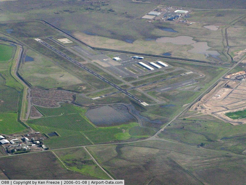
Rio Vista Municipal Airport |
| Rio Vista Municipal Airport |
| IATA: none – ICAO: none – FAA LID: O88 |
| Summary |
| Airport type |
Public |
| Operator |
City of Rio Vista |
| Location |
Rio Vista, California |
| Elevation AMSL |
20 ft / 6.1 m |
| Coordinates |
38°11′36″N 121°42′13″W / 38.19333°N 121.70361°W / 38.19333; -121.70361Coordinates: 38°11′36″N 121°42′13″W / 38.19333°N 121.70361°W / 38.19333; -121.70361 |
| Runways |
| Direction |
Length |
Surface |
| ft |
m |
| 7/25 |
4,200 |
1,280 |
Asphalt |
| 14/32 |
2,200 |
671 |
Asphalt |
| Helipads |
| Number |
Length |
Surface |
| ft |
m |
| H1 |
180 |
55 |
Concrete |
Rio Vista Municipal Airport (FAA LID: O88) is a public airport located three miles (4.8 km) northwest of Rio Vista, serving Solano County, California, USA. This general aviation airport covers 273 acres (110 ha) and has two runways and one helipad. The airport is the current base of operations for the Travis AFB Aero Club.
The above content comes from Wikipedia and is published under free licenses – click here to read more.
|
 |
(Click on the photo to enlarge) |
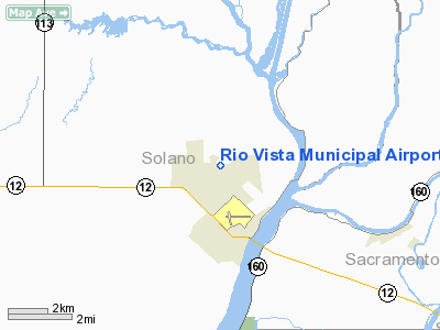
Location
& QuickFacts
|
FAA
Information Effective: |
2006-09-28 |
|
Airport
Identifier: |
O88 |
|
Longitude/Latitude: |
121-42-13.1000W/38-11-36.2000N
-121.703639/38.193389 (Estimated) |
|
Elevation: |
20 ft / 6.10 m (Estimated) |
|
Land: |
273 acres |
|
From
nearest city: |
3 nautical miles NW of Rio Vista, CA |
|
Location: |
Solano County, CA |
|
Magnetic Variation: |
16E (1985) |
Owner
& Manager
|
Ownership: |
Publicly owned |
|
Owner: |
City Of Rio Vista |
|
Address: |
One Main Street
Rio Vista, CA 94571 |
|
Phone
number: |
707-374-6451 |
|
Manager: |
Felix Ajayi |
|
Address: |
798 St. Francis Way, P.o. Box 94571
Rio Vista, CA 94571 |
|
Phone number: |
707-374-6747 |
Airport
Operations and Facilities
|
Airport
Use: |
Open to public |
|
Wind
indicator: |
Yes |
|
Segmented
Circle: |
Yes |
|
Control
Tower: |
No |
|
Attendance
Schedule: |
UNATNDD |
|
Lighting
Schedule: |
DUSK-DAWN
ACTVT MIRL RY 07/25 & RY 14/32, PAPI RYS 07 & 25
AND RYS 14 & 32 - CTAF. |
|
Beacon
Color: |
Clear-Green (lighted land airport) |
|
Landing
fee charge: |
No |
|
Sectional
chart: |
San Francisco |
|
Region: |
AWP - Western-Pacific |
|
Traffic
Pattern Alt: |
1000 ft |
|
Boundary
ARTCC: |
ZOA - Oakland |
|
Tie-in
FSS: |
RIU - Rancho Murieta |
|
FSS
on Airport: |
No |
|
FSS
Phone: |
916-354-0161 |
|
FSS
Toll Free: |
1-800-WX-BRIEF |
|
NOTAMs
Facility: |
RIU (NOTAM-d service avaliable) |
|
Federal Agreements: |
NGY |
Airport
Communications
|
CTAF: |
122.800 |
|
Unicom: |
122.800 |
Airport
Services
|
Fuel
available: |
100LL
FAST PAY FUEL SYSTEM AVBL 24 HRS. |
|
Runway Information
Runway 07/25
|
Dimension: |
4200 x 75 ft / 1280.2 x 22.9 m |
|
Surface: |
ASPH, Good Condition |
|
Weight
Limit: |
Single wheel: 30000 lbs. |
|
Edge
Lights: |
Medium
PERIMETER LGTS. |
|
|
Runway 07 |
Runway 25 |
|
Longitude: |
121-42-34.4067W |
121-41-41.9413W |
|
Latitude: |
38-11-36.4120N |
38-11-39.5138N |
|
Elevation: |
21.00
ft |
21.00
ft |
|
Alignment: |
86 |
127 |
|
Traffic
Pattern: |
Left |
Right |
|
Markings: |
Non-precision instrument, Good Condition |
Non-precision instrument, Good Condition |
|
VASI: |
2-light PAPI on left side |
2-light PAPI on left side |
|
Visual
Glide Angle: |
4.00� |
4.00� |
|
Runway 14/32
|
Dimension: |
2200 x 60 ft / 670.6 x 18.3 m |
|
Surface: |
ASPH, Good Condition |
|
Weight
Limit: |
Single wheel: 12500 lbs. |
|
Edge
Lights: |
Medium
PERIMETER LGTS. |
|
|
Runway 14 |
Runway 32 |
|
Longitude: |
121-42-27.1640W |
121-42-17.7401W |
|
Latitude: |
38-11-42.9893N |
38-11-22.5520N |
|
Elevation: |
22.00
ft |
21.00
ft |
|
Alignment: |
127 |
127 |
|
Traffic
Pattern: |
Left |
Right |
|
Markings: |
Non-precision instrument, Good Condition |
Non-precision instrument, Good Condition |
|
Crossing
Height: |
0.00
ft |
15.00
ft |
|
VASI: |
2-light PAPI on left side |
2-light PAPI on left side |
|
Visual
Glide Angle: |
4.00� |
4.00� |
|
Obstruction: |
, 50:1 slope to clear |
30 ft pole, 510.0 ft from runway, 135 ft right
of centerline, 10:1 slope to clear |
|
Helipad H1
|
Dimension: |
180 x 180 ft / 54.9 x 54.9 m |
|
Surface: |
CONC, |
|
|
Runway H1 |
Runway |
|
Traffic
Pattern: |
Left |
Left |
|
Radio Navigation
Aids
|
ID |
Type |
Name |
Ch |
Freq |
Var |
Dist |
|
LV |
NDB |
Reiga |
|
374.00 |
16E |
30.1 nm |
|
TCY |
NDB |
Tracy |
|
203.00 |
15E |
32.5 nm |
|
SUU |
TACAN |
Travis |
113X |
|
17E |
11.8 nm |
|
NUQ |
TACAN |
Moffett |
123X |
|
17E |
48.7 nm |
|
TZZ |
VOR |
Travis |
|
116.40 |
17E |
10.4 nm |
|
CCR |
VOR/DME |
Concord |
117X |
117.00 |
17E |
18.5 nm |
|
MCC |
VOR/DME |
Mc Clellan |
029X |
109.20 |
17E |
31.8 nm |
|
SFO |
VOR/DME |
San Francisco |
105X |
115.80 |
17E |
46.9 nm |
|
MOD |
VOR/DME |
Modesto |
093X |
114.60 |
17E |
49.1 nm |
|
SAC |
VORTAC |
Sacramento |
099X |
115.20 |
17E |
16.7 nm |
|
SGD |
VORTAC |
Scaggs Island |
058X |
112.10 |
17E |
31.6 nm |
|
ECA |
VORTAC |
Manteca |
107X |
116.00 |
17E |
33.2 nm |
|
LIN |
VORTAC |
Linden |
095X |
114.80 |
17E |
33.8 nm |
|
OAK |
VORTAC |
Oakland |
115X |
116.80 |
17E |
37.4 nm |
|
SAU |
VORTAC |
Sausalito |
109X |
116.20 |
17E |
43.8 nm |
|
SAC |
VOT |
Sacramento Executive |
|
111.40 |
|
21.6 nm |
|
SMF |
VOT |
Sacramento Metropolitan |
|
111.40 |
|
30.4 nm |
|
SFO |
VOT |
San Francisco Intl |
|
111.00 |
|
47.0 nm |
Remarks
- RY
25 CALM WIND RY.
- NOISE
SENSITIVE AREA N OF RY 32. DO NOT OVERFLY RANCH & CORRALS OFF RY
32. ALL
RYS CLIMB TO 700 FT BEFORE TURNS.
- HELIPAD:
NO AUTOROTATIONS HOVERING AUTO'S OR RUNNING LDGS TO PAVEMENT.
Based Aircraft
|
Aircraft
based on field: |
57 |
|
Single
Engine Airplanes: |
51 |
|
Multi
Engine Airplanes: |
5 |
|
Ultralights: |
1 |
Operational Statistics
|
Aircraft
Operations: |
96/Day |
|
General
Aviation Local: |
50.0% |
|
General
Aviation Itinerant: |
50.0% |
Rio Vista Municipal Airport
Address:
Solano County, CA
Tel:
707-374-6451,
707-374-6747
Images
and information placed above are from
http://www.airport-data.com/airport/O88/
We
thank them for the data!
| General
Info |
| Country |
United
States |
| State |
CALIFORNIA
|
| FAA ID |
O88
|
| Latitude |
38-11-36.600N
|
| Longitude |
121-42-08.600W
|
| Elevation |
20 feet
|
| Near City |
RIO VISTA
|
We don't guarantee the information is fresh and accurate. The data may
be wrong or outdated.
For more up-to-date information please refer to other sources.
|
|