 |
|
|
|
|
|
Location
& QuickFacts
|
FAA
Information Effective: |
2006-09-28 |
|
Airport
Identifier: |
L36 |
|
Longitude/Latitude: |
121-26-43.6000W/38-40-30.0000N
-121.445444/38.675000 (Estimated) |
|
Elevation: |
45 ft / 13.72 m (Estimated) |
|
Land: |
40 acres |
|
From
nearest city: |
1 nautical miles S of Rio Linda, CA |
|
Location: |
Sacramento County, CA |
|
Magnetic Variation: |
16E (1985) |
Owner
& Manager
|
Ownership: |
Privately owned |
|
Owner: |
William T Mauser |
|
Address: |
930 E Street
Rio Linda, CA 95673 |
|
Phone
number: |
916-991-1725 |
|
Manager: |
William T Mauser |
|
Address: |
930 E Street
Rio Linda, CA 95673 |
|
Phone number: |
916-991-1725 |
Airport
Operations and Facilities
|
Airport
Use: |
Open to public |
|
Wind
indicator: |
Yes |
|
Segmented
Circle: |
Yes |
|
Control
Tower: |
No |
|
Attendance
Schedule: |
ALL/ALL/0800-1700 |
|
Lighting
Schedule: |
DUSK-2400
ACTVT LIRL RY 17/35 TRIL RY 17 KEY 122.9 SEVEN TIMES. |
|
Beacon
Color: |
Clear-Green (lighted land airport) |
|
Landing
fee charge: |
No |
|
Sectional
chart: |
San Francisco |
|
Region: |
AWP - Western-Pacific |
|
Traffic
Pattern Alt: |
800 ft |
|
Boundary
ARTCC: |
ZOA - Oakland |
|
Tie-in
FSS: |
RIU - Rancho Murieta |
|
FSS
on Airport: |
No |
|
FSS
Phone: |
916-354-0161 |
|
FSS
Toll Free: |
1-800-WX-BRIEF |
|
NOTAMs
Facility: |
RIU (NOTAM-d service avaliable) |
|
Federal Agreements: |
N |
Airport
Communications
|
CTAF: |
123.000 |
|
Unicom: |
123.000 |
Airport
Services
|
Fuel
available: |
100LL |
|
Airframe
Repair: |
MAJOR |
|
Power
Plant Repair: |
MAJOR |
|
Bottled
Oxygen: |
HIGH |
|
Bulk
Oxygen: |
HIGH |
|
Runway Information
Runway 17/35
|
Dimension: |
2625 x 42 ft / 800.1 x 12.8 m |
|
Surface: |
ASPH, Good Condition |
|
Weight
Limit: |
Single wheel: 12000 lbs. |
|
Edge
Lights: |
Low |
|
|
Runway 17 |
Runway 35 |
|
Longitude: |
121-26-42.4650W |
121-26-44.7584W |
|
Latitude: |
38-40-42.9252N |
38-40-17.0364N |
|
Elevation: |
46.00 ft |
44.00 ft |
|
Traffic
Pattern: |
Right |
Left |
|
Markings: |
Nonstandard, Good Condition
/35 NSTD CNTRLN SPACING & WIDTH. |
Nonstandard, Good Condition
RWY 17 /35 NSTD CNTRLN SPACING & WIDTH. |
|
Crossing
Height: |
7.00 ft |
0.00 ft |
|
VASI: |
tri-color on left side |
|
|
Visual
Glide Angle: |
3.50� |
0.00� |
|
Runway
End Identifier: |
No |
No |
|
Obstruction: |
60 ft trees, 927.0 ft from runway, 225 ft right
of centerline, 12:1 slope to clear |
15 ft trees, 550.0 ft from runway, 50 ft left
of centerline, 23:1 slope to clear |
|
Radio Navigation
Aids
|
ID |
Type |
Name |
Ch |
Freq |
Var |
Dist |
|
MY |
NDB |
Halow |
|
222.00 |
16E |
30.7 nm |
|
OVE |
NDB |
Oroville |
|
212.00 |
16E |
50.0 nm |
|
BAB |
TACAN |
Beale |
023X |
|
16E |
27.6 nm |
|
SUU |
TACAN |
Travis |
113X |
|
17E |
34.9 nm |
|
TZZ |
VOR |
Travis |
|
116.40 |
17E |
26.3 nm |
|
MCC |
VOR/DME |
Mc Clellan |
029X |
109.20 |
17E |
2.0 nm |
|
MYV |
VOR/DME |
Marysville |
045X |
110.80 |
16E |
26.2 nm |
|
HNW |
VOR/DME |
Hangtown |
102X |
115.50 |
17E |
32.8 nm |
|
CCR |
VOR/DME |
Concord |
117X |
117.00 |
17E |
47.3 nm |
|
SAC |
VORTAC |
Sacramento |
099X |
115.20 |
17E |
14.8 nm |
|
ILA |
VORTAC |
Williams |
091X |
114.40 |
18E |
36.2 nm |
|
LIN |
VORTAC |
Linden |
095X |
114.80 |
17E |
41.7 nm |
|
SMF |
VOT |
Sacramento Metropolitan |
|
111.40 |
|
6.9 nm |
|
SAC |
VOT |
Sacramento Executive |
|
111.40 |
|
10.0 nm |
Remarks
- <
CLELLAN MC VCNTY TFC JET>
- TOUCH
AND GO LANDINGS NOT AUTHORIZED.
- ULTRALIGHTS
NOT AUTHORIZED.
- FOR
NOISE ABATEMENT RY 17 RIGHT TURN TO HDG 215 DEG AFT TKOF TO AVOID OVERFLIGHT
OF SCHOOL.
- TREE
LINE WEST & NORTH OF ARPT - UNLIGHTED.
Based Aircraft
|
Aircraft
based on field: |
163 |
|
Single
Engine Airplanes: |
150 |
|
Multi
Engine Airplanes: |
13 |
Operational Statistics
|
Aircraft
Operations: |
137/Day |
|
General
Aviation Local: |
62.1% |
|
General
Aviation Itinerant: |
37.9% |
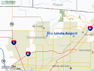
Rio Linda Airport
Address:
Sacramento County, CA
Tel:
916-991-1725
Images
and information placed above are from
http://www.airport-data.com/airport/L36/
We
thank them for the data!
We don't guarantee the information is fresh and accurate. The data may
be wrong or outdated.
For more up-to-date information please refer to other sources.
|
|


