|
|
| Rancho Murieta Airport |
| IATA: none – ICAO: KRIU – FAA LID: RIU |
| Summary |
| Airport type |
Public |
| Owner |
Rancho Murieta Airport Inc. |
| Location |
Rancho Murieta, California |
| Elevation AMSL |
141 ft / 43 m |
| Coordinates |
38°29′12″N 121°06′10″W / 38.48667°N 121.10278°W / 38.48667; -121.10278 |
| Runways |
| Direction |
Length |
Surface |
| ft |
m |
| 4/22 |
3,800 |
1,158 |
Asphalt |
| Statistics (2002) |
| Aircraft operations |
27,500 |
| Based aircraft |
64 |
| Source: Federal Aviation Administration |
"RIU" redirects here. For the hotel chain, see RIU Hotels.
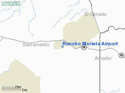
Rancho Murieta Airport (ICAO: KRIU, FAA LID: RIU) is a public-use airport located one mile (1.6 km) west of the central business district of Rancho Murieta, in Sacramento County, California, United States. It is privately owned by Rancho Murieta Airport Inc.
Although most U.S. airports use the same three-letter location identifier for the FAA and IATA, Rancho Murieta Airport is assigned RIU by the FAA but has no designation from the IATA.
Facilities and aircraft
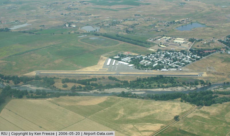
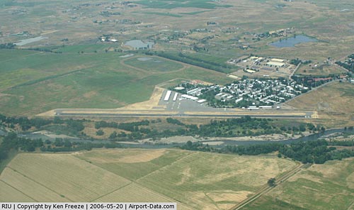
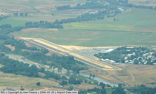
Rancho Murieta Airport covers an area of 76 acres (31 ha) which contains one asphalt paved runway (4/22) measuring 3,800 x 75 ft (1,158 x 23 m).
For the 12-month period ending December 31, 2002, the airport had 27,500 aircraft operations, an average of 75 per day: 96% general aviation and 4% air taxi. There are 64 aircraft based at this airport: 80% single engine, 8% multi-engine, 11% helicopters, and 2% ultralight.
The above content comes from Wikipedia and is published under free licenses – click here to read more.
|
 |
(Click on the photo to enlarge) |
|
 |
(Click on the photo to enlarge) |
Location
& QuickFacts
|
FAA
Information Effective: |
2006-09-28 |
|
Airport
Identifier: |
RIU |
|
Longitude/Latitude: |
121-06-10.0000W/38-29-12.4000N
-121.102778/38.486778 (Estimated) |
|
Elevation: |
141 ft / 42.98 m (Estimated) |
|
Land: |
76 acres |
|
From
nearest city: |
1 nautical miles W of Rancho Murieta, CA |
|
Location: |
Sacramento County, CA |
|
Magnetic Variation: |
16E (1985) |
Owner
& Manager
|
Ownership: |
Privately owned |
|
Owner: |
Rancho Murieta Airport Inc. |
|
Address: |
Po Box 1455
Rancho Murieta, CA 95683 |
|
Phone
number: |
916-354-3200 |
|
Manager: |
Michael Gilmore |
|
Address: |
Po Box 1455
Rancho Murieta, CA 95683 |
|
Phone number: |
916-354-3200 |
Airport
Operations and Facilities
|
Airport
Use: |
Open to public |
|
Wind
indicator: |
Yes |
|
Segmented
Circle: |
Yes |
|
Control
Tower: |
No |
|
Attendance
Schedule: |
ALL/ALL/0800-1700 |
|
Lighting
Schedule: |
0800-1700 |
|
Sectional
chart: |
San Francisco |
|
Region: |
AWP - Western-Pacific |
|
Traffic
Pattern Alt: |
800 ft |
|
Boundary
ARTCC: |
ZOA - Oakland |
|
Tie-in
FSS: |
RIU - Rancho Murieta |
|
FSS
on Airport: |
Yes |
|
FSS
Phone: |
916-354-0161 |
|
FSS
Toll Free: |
1-800-WX-BRIEF |
|
NOTAMs
Facility: |
RIU (NOTAM-d service avaliable) |
|
Federal Agreements: |
N |
Airport
Communications
|
CTAF: |
122.800 |
|
Unicom: |
122.800 |
Airport
Services
|
Fuel
available: |
100LLA |
|
Bottled
Oxygen: |
NONE |
|
Bulk
Oxygen: |
NONE |
|
Runway Information
Runway 04/22
|
Dimension: |
3800 x 75 ft / 1158.2 x 22.9 m |
|
Surface: |
ASPH, Good Condition |
|
|
Runway 04 |
Runway 22 |
|
Longitude: |
121-06-29.1091W |
121-05-50.9407W |
|
Latitude: |
38-29-01.0684N |
38-29-23.6325N |
|
Elevation: |
140.00 ft |
144.00 ft |
|
Traffic
Pattern: |
Right |
Left |
|
Markings: |
Basic, Good Condition |
Basic, Good Condition |
|
Crossing
Height: |
12.00
ft |
12.00
ft |
|
VASI: |
2-box on left side
VASI OTS INDEFLY. |
2-box on left side |
|
Visual
Glide Angle: |
3.00� |
3.00� |
|
Runway
End Identifier: |
No |
No |
|
Touchdown
Lights: |
No |
No |
|
Obstruction: |
8 ft road, 222.0 ft from runway, 2:1 slope
to clear |
95 ft tree, 2370.0 ft from runway, 225 ft right
of centerline, 22:1 slope to clear
+5 FT TREE, 75 FT LEFT OF RWY CENTERLINE, 84 FT FROM END OF
RWY |
|
Radio Navigation
Aids
|
ID |
Type |
Name |
Ch |
Freq |
Var |
Dist |
|
MY |
NDB |
Halow |
|
222.00 |
16E |
47.4 nm |
|
BAB |
TACAN |
Beale |
023X |
|
16E |
42.0 nm |
|
SUU |
TACAN |
Travis |
113X |
|
17E |
42.3 nm |
|
TZZ |
VOR |
Travis |
|
116.40 |
17E |
34.4 nm |
|
MCC |
VOR/DME |
Mc Clellan |
029X |
109.20 |
17E |
17.8 nm |
|
HNW |
VOR/DME |
Hangtown |
102X |
115.50 |
17E |
21.9 nm |
|
MYV |
VOR/DME |
Marysville |
045X |
110.80 |
16E |
42.9 nm |
|
SAC |
VORTAC |
Sacramento |
099X |
115.20 |
17E |
21.3 nm |
|
LIN |
VORTAC |
Linden |
095X |
114.80 |
17E |
25.2 nm |
|
ECA |
VORTAC |
Manteca |
107X |
116.00 |
17E |
39.4 nm |
|
SAC |
VOT |
Sacramento Executive |
|
111.40 |
|
18.7 nm |
|
SMF |
VOT |
Sacramento Metropolitan |
|
111.40 |
|
26.0 nm |
Remarks
- AIRPORT
CLSD AT NIGHT.
- ALL
TNSNT ACFT RQRD TO PARK IN DSGND TSNT AREA.
- DEER
ON & INVOF RWY
- UNMARKED
& UNLIT 65 FT TREES SE & PARALLEL TO RY 04/22.
- +65
FT TREES, +30 FT POWER LINES PARALLEL TO RWY 04/22.
- ALL
ULTRALIGHTS MUST COMPLY WITH FAR 103 AND HAVE AN OPERATING ACFT RADIO.
- VFR
ONLY-TFC PAT TO NW.
Based Aircraft
|
Aircraft
based on field: |
64 |
|
Single
Engine Airplanes: |
51 |
|
Multi
Engine Airplanes: |
5 |
|
Helicopters: |
7 |
|
Ultralights: |
1 |
Operational Statistics
|
Aircraft
Operations: |
76/Day |
|
Air Taxi: |
3.6% |
|
General
Aviation Local: |
30.9% |
|
General
Aviation Itinerant: |
65.5% |
Rancho Murieta Airport
Address:
Sacramento County, CA
Tel:
916-354-3200
Images
and information placed above are from
http://www.airport-data.com/airport/RIU/
We
thank them for the data!
| General
Info |
| Country |
United
States |
| State |
CALIFORNIA
|
| FAA ID |
RIU
|
| Latitude |
38-29-19.671N
|
| Longitude |
121-06-08.801W
|
| Elevation |
141 feet
|
| Near City |
RANCHO
MURIETA |
We don't guarantee the information is fresh and accurate. The data may
be wrong or outdated.
For more up-to-date information please refer to other sources.
|
|