|
|
| Ramona Airport |
 |
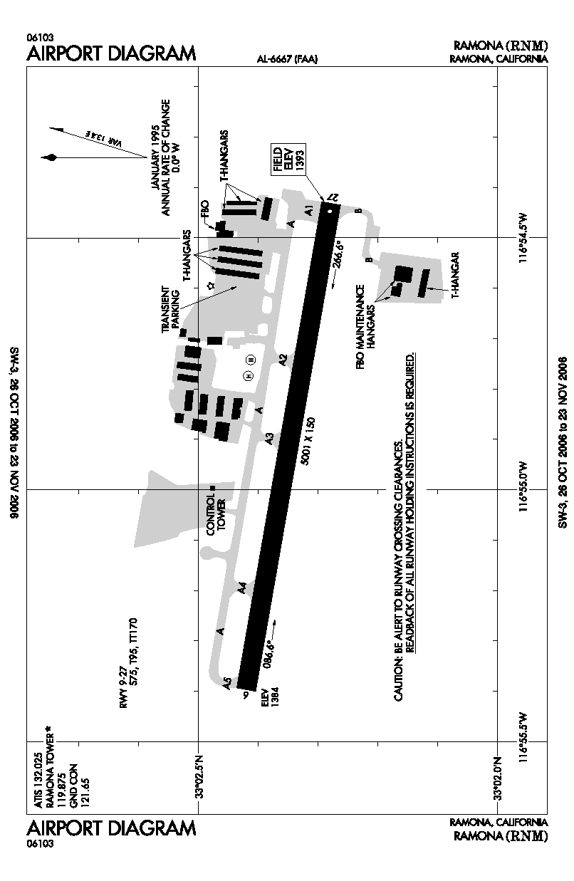
| FAA airport diagram |
| IATA: none – ICAO: KRNM – FAA LID: RNM |
| Summary |
| Airport type |
Public |
| Owner |
County of San Diego |
| Location |
Ramona, California |
| Elevation AMSL |
1,395 ft / 425 m |
| Coordinates |
33°02′21″N 116°54′55″W / 33.03917°N 116.91528°W / 33.03917; -116.91528 |
| Runways |
| Direction |
Length |
Surface |
| ft |
m |
| 9/27 |
5,001 |
1,524 |
Asphalt |
| Helipads |
| Number |
Length |
Surface |
| ft |
m |
| H1 |
340 |
104 |
Asphalt/Concrete |
| Statistics (2005) |
| Aircraft operations |
82,133 |
| Based aircraft |
195 |
| Source: Federal Aviation Administration |
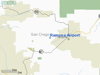
Ramona Airport (ICAO: KRNM, FAA LID: RNM, formerly L39) is a public airport located two miles (3 km) west of the central business district of Ramona, in San Diego County, California, United States. It is owned by the County of San Diego.
The airport is mostly used for general aviation, the California Department of Forestry (CDF) and the United States Forest Service (USFS) jointly operate a fire attack base.
The Ramona Air Fair is a popular airshow held every year in June.
Although most U.S. airports use the same three-letter location identifier for the FAA and IATA, Ramona Airport is assigned RNM by the FAA but has no designation from the IATA.
Facilities and aircraft
Ramona Airport covers an area of 342 acres (138 ha) which contains one runway (9/27: 5,001 x 150 ft.) and one helipad (H1: 340 x 66 ft).
For the 12-month period ending December 31, 2005, the airport had 82,133 aircraft operations, an average of 225 per day: 98% general aviation, 1% air taxi and 1% military. There are 195 aircraft based at this airport: 86% single engine, 8% multi-engine, 1% jet aircraft and 5% helicopters.
For the 12-month period ending December 31, 2007, the airport had 164,691 aircraft operations, an average of 451 per day.
The above content comes from Wikipedia and is published under free licenses – click here to read more.
Location
& QuickFacts
|
FAA
Information Effective: |
2006-09-28 |
|
Airport
Identifier: |
RNM |
|
Longitude/Latitude: |
116-54-54.9000W/33-02-21.0000N
-116.915250/33.039167 (Estimated) |
|
Elevation: |
1395 ft / 425.20 m (Surveyed) |
|
Land: |
342 acres |
|
From
nearest city: |
2 nautical miles W of Ramona, CA |
|
Location: |
San Diego County, CA |
|
Magnetic Variation: |
15E (1965) |
Owner
& Manager
|
Ownership: |
Publicly owned |
|
Owner: |
County Of San Diego |
|
Address: |
1960 Joe Crosson Drive
El Cajon, CA 92020-1235 |
|
Phone
number: |
619-956-4800 |
|
Manager: |
Willie Vasquez
BO DONOVAN, ADMINISTRATOR FOR RAMONA ARPT - CELL 619-742-2631,
CAN ALSO BE REACHED AT FALLBROOK COMMUNITY AIRPARK 760-723-8395. |
|
Address: |
2926 Montecito Road
Ramona, CA 92065 |
|
Phone number: |
760-788-3366
RICHARD SELINGER - CELL PHONE (760) 207-9248. |
Airport
Operations and Facilities
|
Airport
Use: |
Open to public |
|
Wind
indicator: |
Yes |
|
Segmented
Circle: |
Yes |
|
Control
Tower: |
Yes |
|
Attendance
Schedule: |
ALL/ALL/0800-1800 |
|
Lighting
Schedule: |
DUSK-DAWN
ACTVT MIRL RY 09/27; REIL RY 27 & TWY LGTS - CTAF; PAPI
RY 09/27 OPER 24 HRS. |
|
Beacon
Color: |
Clear-Green (lighted land airport) |
|
Landing
fee charge: |
No |
|
Sectional
chart: |
Los Angeles |
|
Region: |
AWP - Western-Pacific |
|
Traffic
Pattern Alt: |
1000 ft |
|
Boundary
ARTCC: |
ZLA - Los Angeles |
|
Tie-in
FSS: |
SAN - San Diego |
|
FSS
on Airport: |
No |
|
FSS
Phone: |
858-277-7043 |
|
FSS
Toll Free: |
1-800-WX-BRIEF |
|
NOTAMs
Facility: |
RNM (NOTAM-d service avaliable) |
|
Federal Agreements: |
NGPY |
Airport
Communications
|
CTAF: |
119.875 |
|
Unicom: |
122.950 |
Airport
Services
|
Fuel
available: |
100LLA |
|
Airframe
Repair: |
MAJOR |
|
Power
Plant Repair: |
MAJOR |
|
Bottled
Oxygen: |
NONE |
|
Bulk
Oxygen: |
NONE |
|
Runway Information
Runway 09/27
|
Dimension: |
5001 x 150 ft / 1524.3 x 45.7 m |
|
Surface: |
ASPH, Good Condition |
|
Weight
Limit: |
Single wheel: 75000 lbs.
Dual wheel: 95000 lbs.
Dual
tandem wheel: 170000 lbs. |
|
Edge
Lights: |
Medium |
|
|
Runway 09 |
Runway 27 |
|
Longitude: |
116-55-23.8457W |
116-54-25.9940W |
|
Latitude: |
33-02-25.2426N |
33-02-16.6840N |
|
Elevation: |
1386.00 ft |
1394.00 ft |
|
Alignment: |
99 |
127 |
|
Traffic
Pattern: |
Left |
Left |
|
Markings: |
Non-precision instrument, Good Condition |
Non-precision instrument, Good Condition |
|
Crossing
Height: |
49.00 ft |
32.00 ft |
|
VASI: |
2-light PAPI on left side |
2-light PAPI on left side |
|
Visual
Glide Angle: |
3.50� |
3.50� |
|
Runway
End Identifier: |
No |
Yes |
|
Centerline
Lights: |
No |
No |
|
Touchdown
Lights: |
No |
No |
|
Radio Navigation
Aids
|
ID |
Type |
Name |
Ch |
Freq |
Var |
Dist |
|
SAN |
FAN MARKER |
Encat |
|
|
15E |
21.7 nm |
|
UN |
NDB |
Tijuana |
|
381.00 |
14E |
31.0 nm |
|
SJY |
NDB |
San Jacinto |
|
227.00 |
14E |
45.6 nm |
|
NKX |
TACAN |
Miramar |
033X |
|
15E |
15.8 nm |
|
NZY |
TACAN |
North Island |
117X |
|
14E |
25.3 nm |
|
NFG |
TACAN |
Camp Pendleton |
055X |
|
13E |
27.6 nm |
|
NRS |
TACAN |
Imperial Beach |
029X |
|
14E |
30.2 nm |
|
NKX |
UHF/NDB |
Miramar |
|
352.00 |
15E |
15.1 nm |
|
HDF |
VOR |
Homeland |
|
113.40 |
14E |
46.3 nm |
|
TIJ |
VOR/DME |
Tijuana |
112X |
116.50 |
14E |
30.1 nm |
|
JLI |
VORTAC |
Julian |
087X |
114.00 |
15E |
17.7 nm |
|
MZB |
VORTAC |
Mission Bay |
125X |
117.80 |
15E |
22.0 nm |
|
PGY |
VORTAC |
Poggi |
035X |
109.80 |
14E |
26.0 nm |
|
OCN |
VORTAC |
Oceanside |
100X |
115.30 |
15E |
28.0 nm |
|
SEE |
VOT |
Gillespie Field |
|
110.00 |
|
13.2 nm |
|
SAN |
VOT |
Mount Soledad |
|
109.00 |
|
20.8 nm |
Remarks
- HELIPADS
N OF RY NOT OPEN TO PUBLIC.
- VOLUNTARY
JET CURFEW 2200-0700. NOISE ABATEMENT: TKOF CLIMB ON RY HDG UNTIL 1900
FT MSL.
- FOREST
SVC FIRE FIGHTING ACFT ON AND INVOF ARPT.
- AIR
TANKERS IN VICINITY MAY-NOV FREQUENTLY FLY NON-STD PAT ENTRIES.
- RY
27 CALM WIND RY.
- FOR
INFO REGARDING FIRE FIGHTING ACTIVITY CALL AMGR (760) 788-3366.
- ULTRALIGHTS
NOT AUTHORIZED.
- BE
ALERT FOR BIRDS YEAR ROUND, VARIOUS SPECIES, LARGE AND SMALL.
Based Aircraft
|
Aircraft
based on field: |
195 |
|
Single
Engine Airplanes: |
167 |
|
Multi
Engine Airplanes: |
16 |
|
Jet Engine
Airplanes: |
2 |
|
Helicopters: |
10 |
Operational Statistics
|
Aircraft
Operations: |
226/Day |
|
Air Carrier: |
0.0% |
|
Air Taxi: |
0.9% |
|
General
Aviation Local: |
98.3% |
|
General
Aviation Itinerant: |
0.0% |
|
Military: |
0.8% |
Ramona Airport
Address:
San Diego County, CA
Tel:
619-956-4800,
760-788-3366
Images
and information placed above are from
http://www.airport-data.com/airport/RNM/
We
thank them for the data!
| General
Info |
| Country |
United
States |
| State |
CALIFORNIA
|
| FAA ID |
RNM
|
| Latitude |
33-02-20.951N
|
| Longitude |
116-54-54.910W
|
| Elevation |
1393 feet
|
| Near City |
RAMONA
|
We don't guarantee the information is fresh and accurate. The data may
be wrong or outdated.
For more up-to-date information please refer to other sources.
|
|