 |
|
Porterville Municipal Airport |
| Porterville Municipal Airport |
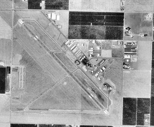 |
| USGS aerial image, 4 September 1994 |
| IATA: PTV – ICAO: KPTV – FAA LID: PTV |
| Summary |
| Airport type |
Public |
| Owner |
City of Porterville |
| Serves |
Porterville, California |
| Elevation AMSL |
442 ft / 135 m |
| Coordinates |
36°01′47″N 119°03′46″W / 36.02972°N 119.06278°W / 36.02972; -119.06278 |
| Runways |
| Direction |
Length |
Surface |
| ft |
m |
| 12/30 |
5,908 |
1,801 |
Asphalt |
| Statistics (2009) |
| Aircraft operations |
43,550 |
| Based aircraft |
92 |
| Source: Federal Aviation Administration |
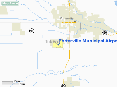
Porterville Municipal Airport (IATA: PTV, ICAO: KPTV, FAA LID: PTV) is a city-owned public-use airport located three nautical miles (6 km) southwest of the central business district of Porterville, a city in Tulare County, California, United States. According to the FAA's National Plan of Integrated Airport Systems for 2009–2013, it is categorized as a general aviation facility. History
The airport was opened in September 1942 as Porterville Army Airfield and was used by the United States Army Air Forces Fourth Air Force as a training base during World War II. It was a sub-base to Lemoore AAF, being used as a pilot training facility. Improvements to the site included a fueling system utilizing nine underground storage tanks. These tanks were filled and abandoned in place. Also located on site are ten fueling pits, which are presently unused. The field had the Air Echelon element from the Western Signal Aviation Unit Training Center at Camp Pinedale.
At the end of the war the airfield was determined to be excess by the military and turned over to the local government for civil use. The War Assets Administration disposed of the property between 1948 and 1953. In 1948, 835 acres (3.38 km) were returned to Porterville. The remaining land was sold to the Tulare County Housing Authority.
Facilities and aircraft
Porterville Municipal Airport covers an area of 940 acres (380 ha) at an elevation of 442 feet (135 m) above mean sea level. It has one runway designated 12/30 with an asphalt surface measuring 5,908 by 150 feet (1,801 x 46 m).
For the 12-month period ending January 30, 2009, the airport had 43,550 aircraft operations, an average of 119 per day: 98% general aviation, 2% air taxi, and <1% military. At that time there were 92 aircraft based at this airport: 73% single-engine, 11% multi-engine, 10% helicopter and 6% ultralight.
The above content comes from Wikipedia and is published under free licenses – click here to read more.
Location
& QuickFacts
|
FAA
Information Effective: |
2006-09-28 |
|
Airport
Identifier: |
PTV |
|
Longitude/Latitude: |
119-03-45.8320W/36-01-46.5880N
-119.062731/36.029608 (Estimated) |
|
Elevation: |
442 ft / 134.72 m (Surveyed) |
|
Land: |
940 acres |
|
From
nearest city: |
3 nautical miles SW of Porterville, CA |
|
Location: |
Tulare County, CA |
|
Magnetic Variation: |
15E (1980) |
Owner
& Manager
|
Ownership: |
Publicly owned |
|
Owner: |
City Of Porterville |
|
Address: |
Po Box 432
Porterville, CA 93257 |
|
Phone
number: |
559-782-7480 |
|
Manager: |
Frank Gayton
FIRE CHIEF ARPT SUPERVISOR: JIM MCDONALD AIRPORT SERVICES
COORDINATOR; PHONE (559) 782-7540. |
|
Address: |
291 N Main
Porterville, CA 93257 |
|
Phone number: |
559-782-7480 |
Airport
Operations and Facilities
|
Airport
Use: |
Open to public |
|
Wind
indicator: |
Yes |
|
Segmented
Circle: |
Yes |
|
Control
Tower: |
No |
|
Attendance
Schedule: |
MAY-OCT/ALL/0700-1900,NOV-APR/ALL/0800-1700
ARPT ATTENDANT 559-782-7540. |
|
Lighting
Schedule: |
DUSK-DAWN
HIRL RY 12/30 PRESET LOW INTST DUSK-2300; AFTER 2300 ACTVT
- CTAF.
ACTVT VASI RY 12 - CTAF, VASI RY 30 OPER
CONTINUOUSLY. |
|
Beacon
Color: |
Clear-Green (lighted land airport) |
|
Landing
fee charge: |
No |
|
Sectional
chart: |
San Francisco |
|
Region: |
AWP - Western-Pacific |
|
Traffic
Pattern Alt: |
1000 ft |
|
Boundary
ARTCC: |
ZLA - Los Angeles |
|
Tie-in
FSS: |
RIU - Rancho Murieta |
|
FSS
on Airport: |
No |
|
FSS
Phone: |
916-354-0161 |
|
FSS
Toll Free: |
1-800-WX-BRIEF |
|
NOTAMs
Facility: |
PTV (NOTAM-d service avaliable) |
|
Federal Agreements: |
NGRY |
Airport
Communications
|
CTAF: |
122.800 |
|
Unicom: |
122.800 |
Airport
Services
|
Fuel
available: |
100LL80 A
SELF SERVICE FUEL AVBL 24 HRS WITH CREDIT CARD. |
|
Airframe
Repair: |
MAJOR |
|
Power
Plant Repair: |
MAJOR |
|
Bottled
Oxygen: |
NONE |
|
Runway Information
Runway 12/30
|
Dimension: |
5908 x 150 ft / 1800.8 x 45.7 m |
|
Surface: |
ASPH, Good Condition |
|
Surface
Treatment: |
Porous Friction Course |
|
Weight
Limit: |
Single wheel: 30000 lbs.
Dual wheel: 70000 lbs.
Dual
tandem wheel: 110000 lbs. |
|
Edge
Lights: |
High |
|
|
Runway 12 |
Runway 30 |
|
Longitude: |
119-04-11.1410W |
119-03-20.5260W |
|
Latitude: |
36-02-07.3420N |
36-01-25.8320N |
|
Elevation: |
430.00 ft |
442.00 ft |
|
Alignment: |
127 |
127 |
|
Traffic
Pattern: |
Left |
Left |
|
Markings: |
Non-precision instrument, Fair Condition |
Non-precision instrument, Fair Condition |
|
Crossing
Height: |
29.00 ft |
60.00 ft |
|
VASI: |
4-box on right side |
4-box on right side |
|
Visual
Glide Angle: |
3.00� |
3.00� |
|
Runway
End Identifier: |
No |
Yes |
|
Centerline
Lights: |
No |
No |
|
Touchdown
Lights: |
No |
No |
|
Obstruction: |
15 ft road, 480.0 ft from runway, 292 ft left
of centerline, 18:1 slope to clear |
15 ft road, 520.0 ft from runway, 298 ft left
of centerline, 21:1 slope to clear |
|
Radio Navigation
Aids
|
ID |
Type |
Name |
Ch |
Freq |
Var |
Dist |
|
COR |
NDB |
Salyer Farms |
|
205.00 |
16E |
23.2 nm |
|
NLC |
TACAN |
Lemoore |
080X |
|
16E |
47.7 nm |
|
TTE |
VOR/DME |
Tule |
029X |
109.20 |
16E |
7.3 nm |
|
VIS |
VOR/DME |
Visalia |
031X |
109.40 |
16E |
28.7 nm |
|
EHF |
VORTAC |
Shafter |
101X |
115.40 |
14E |
32.8 nm |
|
BFL |
VOT |
Bakersfield |
|
111.20 |
|
36.4 nm |
Based Aircraft
|
Aircraft
based on field: |
90 |
|
Single
Engine Airplanes: |
64 |
|
Multi
Engine Airplanes: |
15 |
|
Helicopters: |
5 |
|
Ultralights: |
6 |
Operational Statistics
|
Aircraft
Operations: |
120/Day |
|
Air Taxi: |
2.3% |
|
General
Aviation Local: |
34.4% |
|
General
Aviation Itinerant: |
63.1% |
|
Military: |
0.1% |
Porterville Municipal Airport
Address:
Tulare County, CA
Tel:
559-782-7480
Images
and information placed above are from
http://www.airport-data.com/airport/PTV/
We
thank them for the data!
| General
Info |
| Country |
United
States |
| State |
CALIFORNIA
|
| FAA ID |
PTV
|
| Latitude |
36-01-46.588N
|
| Longitude |
119-03-45.832W
|
| Elevation |
442 feet
|
| Near City |
PORTERVILLE
|
We don't guarantee the information is fresh and accurate. The data may
be wrong or outdated.
For more up-to-date information please refer to other sources.
|
|


