 |
|
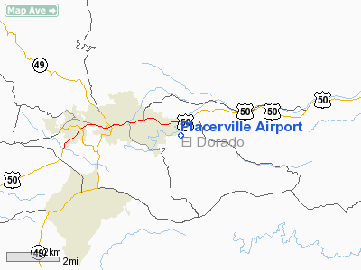
| Placerville Airport |
| IATA: PVF – ICAO: KPVF |
| Summary |
| Airport type |
Public |
| Operator |
El Dorado County |
| Serves |
Placerville, California |
| Elevation AMSL |
2,585 ft / 788 m |
| Coordinates |
38°43′27.2000″N 120°45′12.0000″W / 38.724222°N 120.75333°W / 38.724222; -120.75333 |
| Runways |
| Direction |
Length |
Surface |
| ft |
m |
| 5/23 |
4,201 |
1,280 |
Asphalt |
Placerville Airport (IATA: PVF, ICAO: KPVF) is a public airport located 4 miles (7 km) south of Placerville, in El Dorado County, California, USA. It is a general aviation airport run by the county.
There are no scheduled passenger services departing from the airport. The runway is 4,201 feet, long enough to accommodate medium turboprop aircraft, such as the Pilatus PC-12 and is even home to a T-28 Trojan.
The above content comes from Wikipedia and is published under free licenses – click here to read more.
|
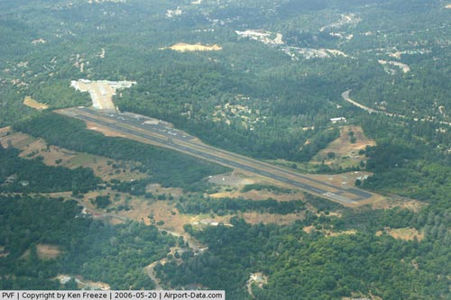 |
(Click on the photo to enlarge) |
|
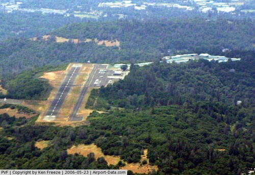 |
(Click on the photo to enlarge) |
Location
& QuickFacts
|
FAA
Information Effective: |
2006-09-28 |
|
Airport
Identifier: |
PVF |
|
Longitude/Latitude: |
120-45-12.0000W/38-43-27.2000N
-120.753333/38.724222 (Estimated) |
|
Elevation: |
2585 ft / 787.91 m (Estimated) |
|
Land: |
243 acres |
|
From
nearest city: |
3 nautical miles E of Placerville, CA |
|
Location: |
El Dorado County, CA |
|
Magnetic Variation: |
17E (1980) |
Owner
& Manager
|
Ownership: |
Publicly owned |
|
Owner: |
El Dorado County |
|
Address: |
Box 85
Placerville, CA 95667 |
|
Phone number: |
916-621-5330 |
|
Manager: |
Michael Gray |
|
Address: |
Po Box 85
Placerville, CA 95667 |
|
Phone number: |
916-621-5330 |
Airport
Operations and Facilities
|
Airport
Use: |
Open to public |
|
Wind
indicator: |
Yes |
|
Segmented
Circle: |
Yes |
|
Control
Tower: |
No |
|
Attendance
Schedule: |
ALL/ALL/0800-1700 |
|
Lighting
Schedule: |
DUSK-DAWN
ACTVT MIRL RY 05/23 AND VASI RYS 05 & 23 - CTAF. |
|
Beacon
Color: |
Clear-Green (lighted land airport) |
|
Landing
fee charge: |
No |
|
Sectional
chart: |
San Francisco |
|
Region: |
AWP - Western-Pacific |
|
Traffic
Pattern Alt: |
800 ft |
|
Boundary
ARTCC: |
ZOA - Oakland |
|
Tie-in
FSS: |
RIU - Rancho Murieta |
|
FSS
on Airport: |
No |
|
FSS
Phone: |
916-354-0161 |
|
FSS
Toll Free: |
1-800-WX-BRIEF |
|
NOTAMs
Facility: |
RIU (NOTAM-d service avaliable) |
|
Federal Agreements: |
NGY |
Airport
Communications
|
CTAF: |
122.800 |
|
Unicom: |
122.800 |
Airport
Services
|
Fuel
available: |
100LL80 A
FUEL AVBL 24 HOURS BY CREDIT CARD. |
|
Airframe
Repair: |
MAJOR |
|
Power
Plant Repair: |
MAJOR |
|
Bottled
Oxygen: |
NONE |
|
Bulk
Oxygen: |
NONE |
|
Runway Information
Runway 05/23
|
Dimension: |
4201 x 75 ft / 1280.5 x 22.9 m |
|
Surface: |
ASPH, Good Condition |
|
Weight
Limit: |
Single wheel: 26000 lbs. |
|
Edge
Lights: |
Medium |
|
|
Runway 05 |
Runway 23 |
|
Longitude: |
120-45-35.5668W |
120-44-48.3841W |
|
Latitude: |
38-43-17.7294N |
38-43-36.6462N |
|
Elevation: |
2579.00 ft |
2581.00 ft |
|
Alignment: |
62 |
127 |
|
Traffic
Pattern: |
Right |
Left |
|
Markings: |
Non-precision instrument, Fair Condition |
Non-precision instrument, Fair Condition |
|
Crossing
Height: |
27.00 ft |
25.00 ft |
|
VASI: |
4-box on left side |
2-box SAVASI on left side |
|
Visual
Glide Angle: |
3.00� |
3.80� |
|
Runway
End Identifier: |
No |
No |
|
Centerline
Lights: |
No |
No |
|
Touchdown
Lights: |
No |
No |
|
Helipad H1
|
Dimension: |
50 x 50 ft / 15.2 x 15.2 m |
|
Surface: |
CONC, |
|
|
Runway H1 |
Runway |
|
Traffic
Pattern: |
Left |
Left |
|
Radio Navigation
Aids
|
ID |
Type |
Name |
Ch |
Freq |
Var |
Dist |
|
MY |
NDB |
Halow |
|
222.00 |
16E |
48.2 nm |
|
BAB |
TACAN |
Beale |
023X |
|
16E |
40.5 nm |
|
HNW |
VOR/DME |
Hangtown |
102X |
115.50 |
17E |
0.2 nm |
|
MCC |
VOR/DME |
Mc Clellan |
029X |
109.20 |
17E |
30.7 nm |
|
SWR |
VOR/DME |
Squaw Valley |
079X |
113.20 |
16E |
35.5 nm |
|
MYV |
VOR/DME |
Marysville |
045X |
110.80 |
16E |
44.5 nm |
|
LIN |
VORTAC |
Linden |
095X |
114.80 |
17E |
40.8 nm |
|
SAC |
VORTAC |
Sacramento |
099X |
115.20 |
17E |
41.1 nm |
|
SAC |
VOT |
Sacramento Executive |
|
111.40 |
|
37.2 nm |
|
SMF |
VOT |
Sacramento Metropolitan |
|
111.40 |
|
39.3 nm |
Remarks
- RUNWAY
SAFETY AREAS ARE NON-STANDARD LENGTH, SEVERE DROP OFF 100 FEET BEYOND
END OF RWY 5 AND RWY 23.
- PPR
FOR TGL FOR ACFT OVER 12500 LBS.
- FORESTRY
HELITAC BASE AT EAST END OF ARPT.
- HEL
PARKING AT NW END OF RWY.
- NOISE
ABATEMENT PROCEDURE: NO MID-FIELD DEPS; NO TURNS WEST OR NORTH PRIOR
TO 3400 MSL OR CLEAR OF NOISE SENSITIVE AREA. RY 23 AFTER TKOF MAKE
10 DEG LEFT TURN AT EOR TO AVOID NOISE SENSITIVE RESIDENTIAL AREAS.
- DEER
ON AND INVOF RY ESPECIALLY NGTS.
- HELIPAD
LCTD ON NORTH SIDE OF RY 23 END; TFC PAT & NOISE ABATEMENT PROCEDURES
APPLY.
Based Aircraft
|
Aircraft
based on field: |
195 |
|
Single
Engine Airplanes: |
188 |
|
Multi
Engine Airplanes: |
4 |
|
Helicopters: |
1 |
|
Ultralights: |
2 |
Operational Statistics
|
Aircraft
Operations: |
181/Day |
|
Air Taxi: |
1.5% |
|
General
Aviation Local: |
45.5% |
|
General
Aviation Itinerant: |
51.5% |
|
Military: |
1.5% |
Placerville Airport
Address:
El Dorado County, CA
Tel:
916-621-5330
Images
and information placed above are from
http://www.airport-data.com/airport/PVF/
We
thank them for the data!
| General
Info |
| Country |
United
States |
| State |
CALIFORNIA
|
| FAA ID |
PVF
|
| Latitude |
38-43-27.185N
|
| Longitude |
120-45-11.970W
|
| Elevation |
2583 feet
|
| Near City |
PLACERVILLE
|
We don't guarantee the information is fresh and accurate. The data may
be wrong or outdated.
For more up-to-date information please refer to other sources.
|
|


