|
|
Pine Mountain Lake Airport |
| Pine Mountain Lake Airport |
 |
| IATA: none – ICAO: none – FAA LID: E45 |
| Summary |
| Airport type |
Tuolumne County |
| Operator |
Groveland, California |
| Elevation AMSL |
2,930 ft / 893.1 m |
| Coordinates |
37°51′42″N 120°10′40″W / 37.86167°N 120.17778°W / 37.86167; -120.17778 |
| Runways |
| Direction |
Length |
Surface |
| ft |
m |
| 9/27 |
3,625 |
1,105 |
Asphalt |
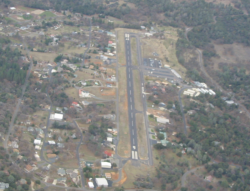
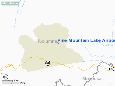
Pine Mountain Lake Airport (FAA LID: E45), formerly Q68, is a public airport located three miles (4.8 km) northeast of Groveland, serving Tuolumne County, California, USA. The airport is used mostly for general aviation. The airport is part of the Pine Mountain Lake community. The airport has public access.
Facilities
Pine Mountain Lake Airport covers 52 acres and has one runway:
- Runway 9/27: 3,625 x 50 ft (1,105 x 15 m), Surface: Asphalt
Cautions to pilots: "Be alert deer on and in vicinity of airport especially Nov-Apr."
The above content comes from Wikipedia and is published under free licenses – click here to read more.
Location
& QuickFacts
|
FAA
Information Effective: |
2006-09-28 |
|
Airport
Identifier: |
E45 |
|
Longitude/Latitude: |
120-10-40.4000W/37-51-42.0000N
-120.177889/37.861667 (Estimated) |
|
Elevation: |
2930 ft / 893.06 m (Surveyed) |
|
Land: |
52 acres |
|
From
nearest city: |
3 nautical miles NE of Groveland, CA |
|
Location: |
Tuolumne County, CA |
|
Magnetic Variation: |
15E (1995) |
Owner
& Manager
|
Ownership: |
Publicly owned |
|
Owner: |
Tuloumne County |
|
Address: |
2 South Green St.
Sonora, CA 95370 |
|
Phone
number: |
209-533-5685 |
|
Manager: |
Jim Thomas |
|
Address: |
10723 Airport Rd
Columbia, CA 95310 |
|
Phone
number: |
209-533-5685
OFFICE AT COLUMBIA, CA ARPT. |
Airport
Operations and Facilities
|
Airport
Use: |
Open to public |
|
Wind
indicator: |
Yes |
|
Segmented
Circle: |
Yes |
|
Control
Tower: |
No |
|
Attendance
Schedule: |
ALL/ALL/0800-1700 |
|
Lighting
Schedule: |
DUSK-DAWN
ACTVT MIRL RY 09/27 - CTAF. |
|
Beacon
Color: |
Clear-Green (lighted land airport) |
|
Landing
fee charge: |
Yes |
|
Sectional
chart: |
San Francisco |
|
Region: |
AWP - Western-Pacific |
|
Traffic
Pattern Alt: |
1000 ft |
|
Boundary
ARTCC: |
ZOA - Oakland |
|
Tie-in
FSS: |
RIU - Rancho Murieta |
|
FSS
on Airport: |
No |
|
FSS
Phone: |
916-354-0161 |
|
FSS
Toll Free: |
1-800-WX-BRIEF |
|
NOTAMs
Facility: |
RIU (NOTAM-d service avaliable) |
|
Federal Agreements: |
NGY |
Airport
Communications
Airport
Services
|
Fuel
available: |
100LL
FUEL 24 HR SELF-SERVICE. |
|
Airframe
Repair: |
MAJOR |
|
Power
Plant Repair: |
MAJOR |
|
Bottled
Oxygen: |
NONE |
|
Bulk
Oxygen: |
NONE |
|
Runway Information
Runway 09/27
|
Dimension: |
3625
x 50 ft / 1104.9 x 15.2 m
200 FT GRVL RY SAFETY AREA WEST END; 100 FT GRVL RY SAFETY AREA
EAST END. |
|
Surface: |
ASPH, Good Condition |
|
Weight
Limit: |
Single wheel: 12000 lbs. |
|
Edge
Lights: |
Medium |
|
|
Runway 09 |
Runway 27 |
|
Longitude: |
120-11-01.5000W |
120-10-19.2000W |
|
Latitude: |
37-51-48.2580N |
37-51-35.7260N |
|
Elevation: |
2891.00 ft |
2930.00 ft |
|
Alignment: |
110 |
127 |
|
Traffic
Pattern: |
Left |
Right |
|
Markings: |
Basic, Fair Condition |
Basic, Fair Condition |
|
Crossing
Height: |
16.00
ft |
37.00 ft |
|
VASI: |
2-box on left side |
2-light PAPI on left side
PAPI UNUSABLE BYD 7 DEGS EITHER SIDE OF RY CNTRLN. |
|
Visual
Glide Angle: |
4.50� |
4.00� |
|
Obstruction: |
35 ft trees, 800.0 ft from runway, 75 ft left
of centerline, 17:1 slope to clear |
35 ft trees, 980.0 ft from runway, 22:1 slope
to clear |
|
Radio Navigation
Aids
|
ID |
Type |
Name |
Ch |
Freq |
Var |
Dist |
|
MOD |
VOR/DME |
Modesto |
093X |
114.60 |
17E |
39.7 nm |
|
HYP |
VOR/DME |
El Nido |
089X |
114.20 |
15E |
40.0 nm |
|
LIN |
VORTAC |
Linden |
095X |
114.80 |
17E |
41.2 nm |
|
ECA |
VORTAC |
Manteca |
107X |
116.00 |
17E |
47.2 nm |
Remarks
- TRANSIENT
PARKING AVBL.
- FEE
FOR OVERNIGHT PARKING.
- DEER
ON & INVOF ARPT AT ALL TIMES.
- TREES
IN APCHS ARE TO BE TOPPED OR REMOVED.
Based Aircraft
|
Aircraft
based on field: |
113 |
|
Single
Engine Airplanes: |
105 |
|
Multi
Engine Airplanes: |
5 |
|
Helicopters: |
3 |
Operational Statistics
|
Aircraft
Operations: |
91/Day |
|
General
Aviation Local: |
45.5% |
|
General
Aviation Itinerant: |
54.5% |
Pine Mountain Lake Airport
Address:
Tuolumne County, CA
Tel:
209-533-5685
Images
and information placed above are from
http://www.airport-data.com/airport/E45/
We
thank them for the data!
| General
Info |
| Country |
United
States |
| State |
CALIFORNIA
|
| FAA ID |
E45
|
| Latitude |
37.861668
37� 51' 42.00" N |
| Longitude |
-120.177890
120� 10' 40.40" W |
| Elevation |
2930 feet
893 meters |
| Magnetic
Variation |
014� E
(01/06) |
| Beacon |
Yes
|
| Operating
Agency |
U.S.CIVIL
AIRPORT WHEREIN PERMIT COVERS USE BY TRANSIT MILITARY AIRCRAFT
|
| Daylight
Savings Time |
First
Sunday in April at 0200 to last Sunday in October at 0200 local time
(Exception Arizona and that portion of Indiana in the Eastern Time
Zone) |
We don't guarantee the information is fresh and accurate. The data may
be wrong or outdated.
For more up-to-date information please refer to other sources.
|
|