 |
|
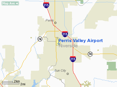
| Perris Valley Airport |
| 220px |
| IATA: none – ICAO: none |
| Summary |
| Airport type |
Private |
| Owner |
B & D Conatser |
| Operator |
B & D Conatser |
| Serves |
Riverside County, California |
| Location |
Perris, California |
| Elevation AMSL |
1413 ft / 431 m |
| Coordinates |
33°45′52.7″N 117°13′8.4″W / 33.764639°N 117.219°W / 33.764639; -117.219 |
| Runways |
| Direction |
Length |
Surface |
| ft |
m |
| 15/33 |
5,100 |
1,554 |
Asphalt |
| Statistics (2004) |
| GA flights |
34,200 |
| Skydives |
130,000 |
| FAA data Perris Valley Skydiving |
Perris Valley Airport (FAA LID: L65) is a privately owned and operated airport open to public use and located one mile (1.6 km) southeast of Perris serving Riverside County, California. The airport has one runway and is used for general aviation and extensive skydiving. The airport operates from dawn to dusk daily year-round. A skydiving drop zone operates at the airport, and skydivers land about 50 feet from the runway.
The primary occupant is Perris Valley Skydiving. Skydiving operations run from early morning to dusk daily unless limited by weather or safety factors. Perris Valley Skydiving (PVS) operates a fleet of five aircraft. The fleet consists of a Skyvan, a Super 300 Twin Otter, two Super Twin Otters, and a twin engine DC-9 jet. The DC-9 is the only civilian jet FAA-certified for skydiving. Skydivers fly to jump altitude (13,000 feet) in about 20 minutes. PVS provides skydiving opportunities to beginners and experts alike. Beginners can choose static line, tandem, or Accelerated Freefall skydiving. Facilities
Perris Valley Airport has one runway:
- Runway 15/33: 5,100 feet (1,600 m) x 50 feet (15 m). Surface: Asphalt.
The airport does not have a control tower, runway lights, or approach lights. The Federal Aviation Administration (FAA) classifies the northern 1,900 feet (580 m) section of runway in poor condition. FAA inspectors determined the remaining 3,200 feet (980 m) section of runway is in good condition. The northern 1,000 feet (300 m) is closed indefinitely. Aircraft maintenance and repair services are available. The airport provides aviation fuel to the general public only on an emergency basis. The airport is home to 125 ultralight aircraft and 16 conventional aircraft. Conventional aircraft include ten single engine planes, five twin engine planes, and one jet aircraft.
Accidents and incidents
- On 4 May 1984, Douglas DC-3C N157U of Perris Valley Paracenter was damaged beyond economic repair when the port engine lost a propellor blade on take-off, causing the engine to be torn from its mountings. There were no injuries amongst the two crew and 31 parachutists on board. A mandatory Airworthiness Directive had been issued concerning the propellor, but an investigation found no evidence that it had been complied with.
- On April 22, 1992, a skydiving aircraft lost engine power during takeoff and crashed. The plane never climbed more than 50 feet above the runway. Sixteen people (2 pilots and 14 skydivers) died in the crash. The National Transportation Safety Board (NTSB) attributed engine failure to aviation fuel contaminated by improper fuel handling. The pilots' response to engine failure also contributed to the crash.
The above content comes from Wikipedia and is published under free licenses – click here to read more.
Location
& QuickFacts
|
FAA
Information Effective: |
2006-09-28 |
|
Airport
Identifier: |
L65 |
|
Longitude/Latitude: |
117-13-06.1280W/33-45-39.0710N
-117.218369/33.760853 (Estimated) |
|
Elevation: |
1413 ft / 430.68 m (Estimated) |
|
Land: |
217 acres |
|
From
nearest city: |
1 nautical miles SE of Perris, CA |
|
Location: |
Riverside County, CA |
|
Magnetic Variation: |
14E (1985) |
Owner
& Manager
|
Ownership: |
Privately owned |
|
Owner: |
B & D Conatser |
|
Address: |
2091 Goetz Road
Perris, CA 92570 |
|
Phone
number: |
951-943-3797 |
|
Manager: |
Pat Conatser |
|
Address: |
P.o. Box 1823
Perris, CA 92370 |
|
Phone
number: |
951-943-9673
MAIN OFFICE TO LEAVE MSGS W/SECY - (951) 657-3904 FAX: (951)
657-6178.
EMAIL: PERRISAIR@AOL.COM |
Airport
Operations and Facilities
|
Airport
Use: |
Open to public |
|
Wind
indicator: |
Yes |
|
Segmented
Circle: |
Yes |
|
Control
Tower: |
No |
|
Attendance
Schedule: |
ALL/ALL/DAWN-DUSK |
|
Landing
fee charge: |
No |
|
Sectional
chart: |
Los Angeles |
|
Region: |
AWP - Western-Pacific |
|
Traffic
Pattern Alt: |
1000 ft |
|
Boundary
ARTCC: |
ZLA - Los Angeles |
|
Tie-in
FSS: |
RAL - Riverside |
|
FSS
on Airport: |
No |
|
FSS
Phone: |
951-351-3020 |
|
FSS
Toll Free: |
1-800-WX-BRIEF |
|
NOTAMs
Facility: |
RAL (NOTAM-d service avaliable) |
Airport
Communications
Airport
Services
|
Fuel
available: |
100LLA
FUEL AVBL FOR EMERG USE ONLY. |
|
Airframe
Repair: |
MAJOR |
|
Power
Plant Repair: |
MAJOR |
|
Bottled
Oxygen: |
NONE |
|
Bulk
Oxygen: |
NONE |
|
Runway Information
Runway 15/33
|
Dimension: |
5100 x 50 ft / 1554.5 x 15.2 m |
|
Surface: |
ASPH, Poor Condition
RWY 15/33 N 1900 FT ASPH POOR COND; REMAINING 3200 FT ASPH GOOD
COND. |
|
|
Runway 15 |
Runway 33 |
|
Elevation: |
1413.00 ft |
0.00
ft |
|
Traffic
Pattern: |
Right |
Left |
|
Markings: |
Nonstandard, Fair Condition
RWY 15 /33 NON-STD SIZE NRS. |
Nonstandard, Good Condition |
|
Displaced
threshold: |
1900.00 ft |
144.00 ft |
|
Obstruction: |
30 ft trees, 150.0 ft from runway, 5:1 slope
to clear
APCH RATIO TO DSPLCD THR 50:1. |
, 50:1 slope to clear
APCH RATIO TO DSPLCD THLD 50:1. |
|
Radio Navigation
Aids
|
ID |
Type |
Name |
Ch |
Freq |
Var |
Dist |
|
SJY |
NDB |
San Jacinto |
|
227.00 |
14E |
11.1 nm |
|
SB |
NDB |
Petis |
|
397.00 |
14E |
19.2 nm |
|
EMT |
NDB |
El Monte |
|
359.00 |
15E |
45.1 nm |
|
RIV |
TACAN |
March |
077X |
|
14E |
9.2 nm |
|
NFG |
TACAN |
Camp Pendleton |
055X |
|
13E |
30.4 nm |
|
HDF |
VOR |
Homeland |
|
113.40 |
14E |
1.9 nm |
|
RAL |
VOR |
Riverside |
|
112.40 |
15E |
16.3 nm |
|
ELB |
VOR/DME |
El Toro |
119X |
117.20 |
14E |
26.1 nm |
|
PDZ |
VORTAC |
Paradise |
059X |
112.20 |
15E |
18.2 nm |
|
OCN |
VORTAC |
Oceanside |
100X |
115.30 |
15E |
32.8 nm |
|
POM |
VORTAC |
Pomona |
041X |
110.40 |
15E |
34.2 nm |
|
PSP |
VORTAC |
Palm Springs |
102X |
115.50 |
13E |
39.9 nm |
|
SLI |
VORTAC |
Seal Beach |
104X |
115.70 |
15E |
41.8 nm |
|
JLI |
VORTAC |
Julian |
087X |
114.00 |
15E |
49.0 nm |
|
SNA |
VOT |
Santa Ana |
|
110.00 |
|
33.0 nm |
Remarks
- EXTSV
ULTRALIGHT & PARACHUTING ACTIVITIES DAILY; DO NOT OVERFLY AIRPORT;
AVOID AIRSPACE ADJ EAST. ULTRALIGHTS ON & INVOF ARPT. ULTRALIGHT
AND PARACHUTING ACTIVITIES CAN BE MONITORED ON FREQ 122.775.
- RY
15/33 NORTH 1,000 FT CLSD INDEFLY.
- EXISTED
PRIOR TO 5/15/59.
Based Aircraft
|
Aircraft
based on field: |
141 |
|
Single
Engine Airplanes: |
10 |
|
Multi
Engine Airplanes: |
5 |
|
Jet Engine
Airplanes: |
1 |
|
Ultralights: |
125 |
Operational Statistics
|
Aircraft
Operations: |
94/Day |
|
General
Aviation Local: |
80.0% |
|
General
Aviation Itinerant: |
20.0% |
Perris Valley Airport
Address:
Riverside County, CA
Tel:
951-943-3797,
951-943-9673
FAX:
(951) 657-6178
EMAIL: PERRISAIR@AOL.COM
Images
and information placed above are from
http://www.airport-data.com/airport/L65/
We
thank them for the data!
| General
Info |
| Country |
United
States |
| State |
CALIFORNIA
|
| FAA ID |
L65
|
| Latitude |
33-45-39.071N
|
| Longitude |
117-13-06.128W
|
| Elevation |
1413 feet
|
| Near City |
PERRIS
|
We don't guarantee the information is fresh and accurate. The data may
be wrong or outdated.
For more up-to-date information please refer to other sources.
|
|


