|
|
Palm Springs International Airport |
| Palm Springs International Airport |
 |
| IATA: PSP – ICAO: KPSP – FAA LID: PSP
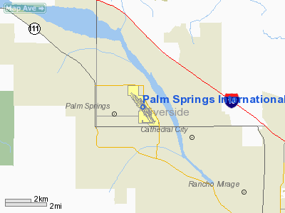
Location of the Palm Springs International Airport
|
| Summary |
| Airport type |
Public |
| Operator |
City of Palm Springs |
| Serves |
Palm Springs / Inland Empire |
| Location |
Palm Springs, California |
| Elevation AMSL |
477 ft / 145.4 m |
| Coordinates |
33°49′46.8″N 116°30′24.1″W / 33.829667°N 116.506694°W / 33.829667; -116.506694Coordinates: 33°49′46.8″N 116°30′24.1″W / 33.829667°N 116.506694°W / 33.829667; -116.506694 |
| Website |
Palm Springs International Airport |
| Runways |
| Direction |
Length |
Surface |
| ft |
m |
| 13R/31L |
10,001 |
3,048 |
Asphalt |
| 13L/31R |
4,952 |
1,509 |
Asphalt |
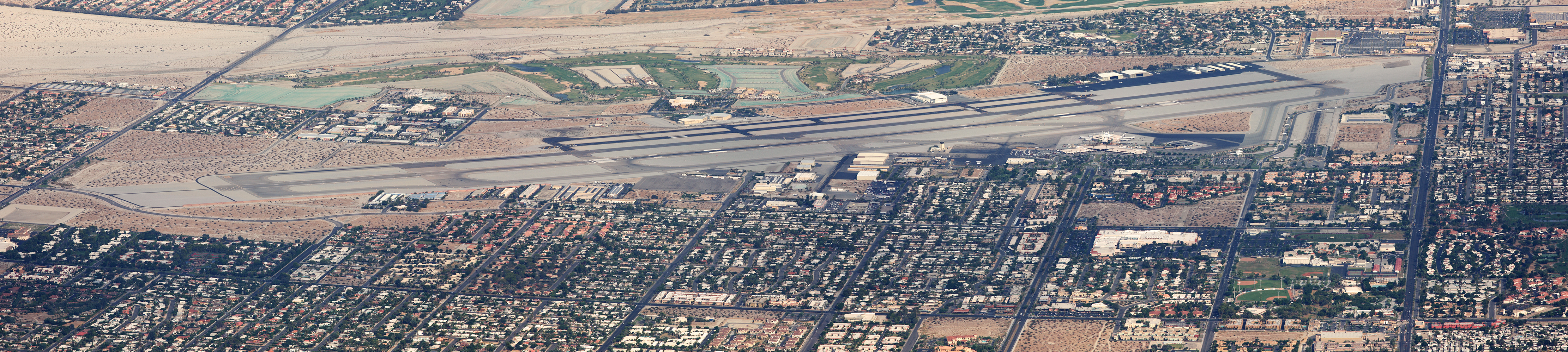
Palm Springs International Airport (IATA: PSP, ICAO: KPSP, FAA LID: PSP) is a public airport located two miles (3 km) east of the central business district (CBD) of Palm Springs, California, serving the Inland Empire Metropolitan Area of Southern California. The airport covers 940 acres (380 ha) and has two runways. It is highly seasonal, in that many flights do not operate during the summer.
PSP was originally constructed as a United States Army Air Forces airfield in 1939 on land owned by the Agua Caliente Band of Cahuilla Indians. The City of Palm Springs purchased the land in 1961 and converted it for commercial use, which began in 1964 as the Palm Springs Municipal Airport.
On December 30, 2006, Air Force One left Palm Springs International Airport with the body of the 38th President of the United States, Gerald R. Ford. The body of the President was flown to Washington, D.C., for official federal services. Airlines and destinations
 | |
Palm Springs International Airport |
| Airlines |
Destinations |
| Alaska Airlines |
Portland (OR) [seasonal], San Francisco, Seattle/Tacoma |
| Allegiant Air |
Bellingham [seasonal] |
| American Airlines |
Chicago-O’Hare [seasonal], Dallas/Fort Worth |
| Delta Air Lines |
Minneapolis/St. Paul [seasonal] |
| Delta Connection operated by SkyWest Airlines |
Salt Lake City |
| Sun Country Airlines |
Minneapolis/St. Paul [seasonal] |
| Horizon Air |
Sacramento |
| United Airlines |
Chicago-O’Hare, Denver [both seasonal] |
| United Express operated by SkyWest Airlines |
Denver, Las Vegas, Los Angeles, San Francisco |
| US Airways Express operated by Mesa Airlines |
Phoenix |
| WestJet |
Calgary, Edmonton [seasonal], Toronto-Pearson [seasonal; begins February 2], Vancouver [seasonal] |
The above content comes from Wikipedia and is published under free licenses – click here to read more.
Location
& QuickFacts
|
FAA
Information Effective: |
2006-09-28 |
|
Airport
Identifier: |
PSP |
|
Longitude/Latitude: |
116-30-24.1000W/33-49-46.8000N
-116.506694/33.829667 (Estimated) |
|
Elevation: |
477 ft / 145.39 m (Surveyed) |
|
Land: |
940 acres |
|
From
nearest city: |
2 nautical miles E of Palm Springs, CA |
|
Location: |
Riverside County, CA |
|
Magnetic Variation: |
13E (1990) |
Owner
& Manager
|
Ownership: |
Publicly owned |
|
Owner: |
City Of Palm Springs |
|
Address: |
3400 E. Tahquitz Canyon Way
Palm Springs, CA 92263 |
|
Phone
number: |
760-318-3800 |
|
Manager: |
Richard S. Walsh, Aae
DIRECTOR OF AVIATION |
|
Address: |
3400 E. Tahquitz-canyon Way, Suite Ofc
Palm Springs, CA 92262 |
|
Phone number: |
760-318-3800 |
Airport
Operations and Facilities
|
Airport
Use: |
Open to public |
|
Wind
indicator: |
Yes |
|
Segmented
Circle: |
Yes |
|
Control
Tower: |
Yes |
|
Attendance
Schedule: |
ALL/ALL/ALL |
|
Lighting
Schedule: |
DUSK-DAWN
WHEN ATCT CLSD ACTVT HIRL RY 13R/31L - CTAF. VASI AND REIL
RYS 13R & 31L, PAPI AND REIL RYS 13L & 31R UNAVBL
2300-0600. RY
13L/31R MIRL & TWY E NOT LIGHTED FM 2300-0600. |
|
Beacon
Color: |
Clear-Green (lighted land airport) |
|
Landing
fee charge: |
No |
|
Sectional
chart: |
Los Angeles |
|
Region: |
AWP - Western-Pacific |
|
Boundary
ARTCC: |
ZLA - Los Angeles |
|
Tie-in
FSS: |
RAL - Riverside |
|
FSS
on Airport: |
No |
|
FSS
Phone: |
951-351-3020 |
|
FSS
Toll Free: |
1-800-WX-BRIEF |
|
NOTAMs
Facility: |
PSP (NOTAM-d service avaliable) |
|
Certification type/date: |
I CS 5/1973 |
|
Federal Agreements: |
NGPY3 |
Airport
Communications
|
CTAF: |
119.700 |
|
Unicom: |
122.950 |
Airport
Services
|
Fuel
available: |
100LLA |
|
Airframe
Repair: |
MAJOR |
|
Power
Plant Repair: |
MAJOR |
|
Bottled
Oxygen: |
LOW |
|
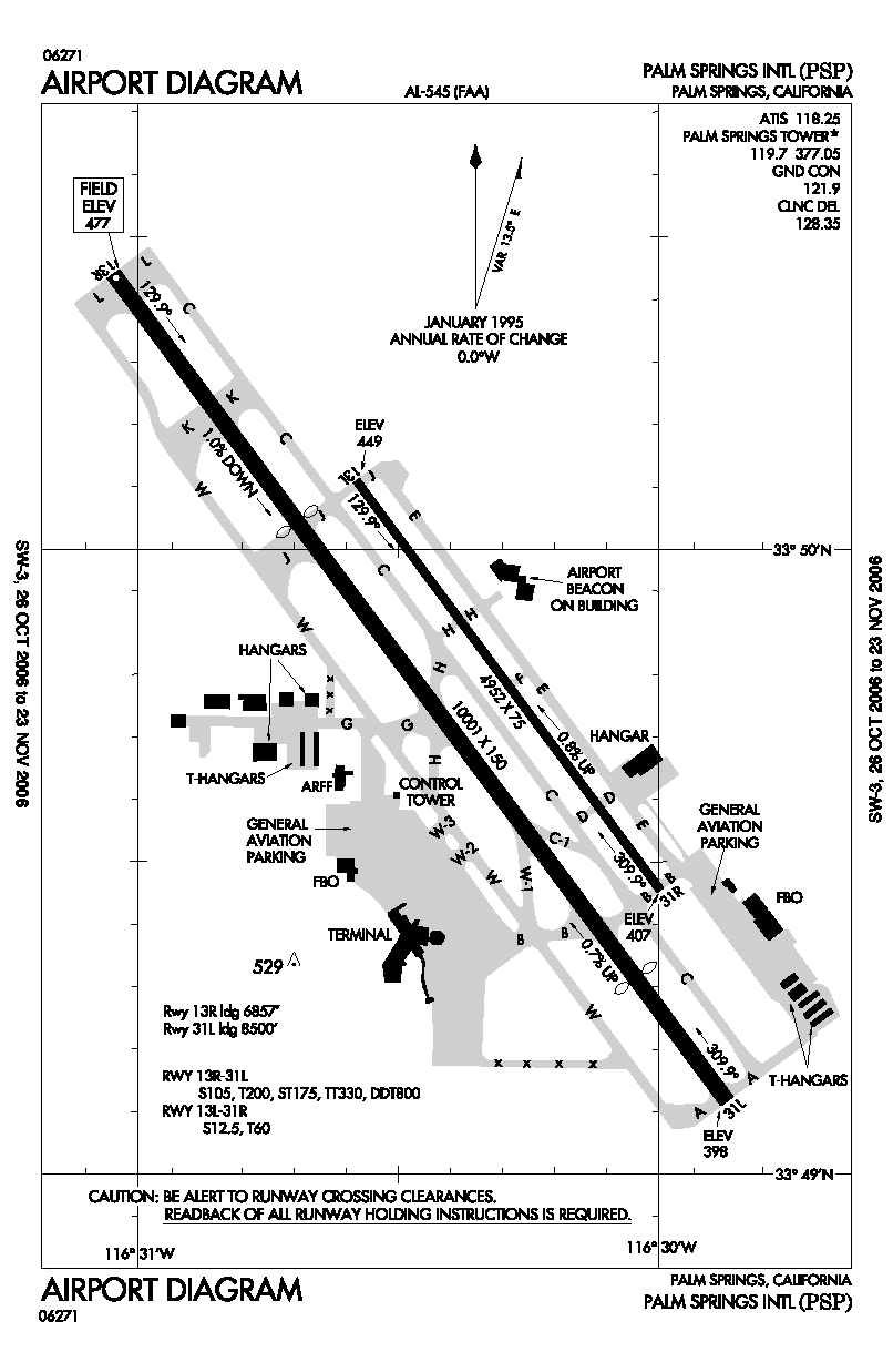
Runway Information
Runway 13L/31R
|
Dimension: |
4952 x 75 ft / 1509.4 x 22.9 m |
|
Surface: |
ASPH, Good Condition |
|
Weight
Limit: |
Single wheel: 12500 lbs.
Dual wheel: 60000 lbs.
FAA STRENGTH EVALUATION DC-10-10 60000 LBS; DC-10-30 700000 LBS;
L-1011 600000 LBS. |
|
Edge
Lights: |
Medium |
|
|
Runway 13L |
Runway 31R |
|
Longitude: |
116-30-34.8012W |
116-29-59.7988W |
|
Latitude: |
33-50-06.5954N |
33-49-27.2672N |
|
Elevation: |
449.00 ft |
407.00 ft |
|
Alignment: |
127 |
127 |
|
Traffic
Pattern: |
Left |
Right |
|
Markings: |
Basic, Good Condition |
Basic, Good Condition |
|
VASI: |
4-light PAPI on left side |
4-light PAPI on left side |
|
Visual
Glide Angle: |
3.50� |
3.50� |
|
Runway
End Identifier: |
Yes |
Yes |
|
Runway 13R/31L
|
Dimension: |
10001 x 150 ft / 3048.3 x 45.7 m |
|
Surface: |
ASPH, Good Condition |
|
Surface
Treatment: |
Porous Friction Course |
|
Weight
Limit: |
Single wheel: 105000 lbs.
Dual wheel: 200000 lbs.
Dual tandem wheel: 330000 lbs.
Dual dual tandem wheel: 800000 lbs.
FAA
STRENGTH EVALUATION DC-10-10 60000 LBS; DC-10-30 700000 LBS; L-1011
600000 LBS. |
|
Edge
Lights: |
High |
|
|
Runway 13R |
Runway 31L |
|
Longitude: |
116-31-02.8131W |
116-29-52.1279W |
|
Latitude: |
33-50-26.4463N |
33-49-07.0294N |
|
Elevation: |
477.00 ft |
398.00 ft |
|
Alignment: |
127 |
127 |
|
Traffic
Pattern: |
Left |
Right |
|
Markings: |
Precision instrument, Good Condition |
Precision instrument, Good Condition |
|
Displaced
threshold: |
3000.00 ft |
1500.00 ft |
|
VASI: |
6-box on left side |
6-box on left side |
|
Runway
End Identifier: |
Yes |
Yes |
|
Centerline
Lights: |
No |
No |
|
Touchdown
Lights: |
No |
No |
|
Decleard
distances: |
Take off run available 10000.00 ft
Take off distance available 10000.00 ft
Actual stop distance available 9857.00 ft
Landing distance available 6857.00 ft |
Take off run available 10000.00 ft
Take off distance available 10000.00 ft
Actual stop distance available 10000.00 ft
Landing distance available 8500.00 ft |
|
Radio Navigation
Aids
|
ID |
Type |
Name |
Ch |
Freq |
Var |
Dist |
|
SJY |
NDB |
San Jacinto |
|
227.00 |
14E |
24.7 nm |
|
SB |
NDB |
Petis |
|
397.00 |
14E |
45.0 nm |
|
NXP |
TACAN |
Coyote |
063X |
|
14E |
33.0 nm |
|
RIV |
TACAN |
March |
077X |
|
14E |
38.6 nm |
|
HDF |
VOR |
Homeland |
|
113.40 |
14E |
34.0 nm |
|
RAL |
VOR |
Riverside |
|
112.40 |
15E |
47.6 nm |
|
PSP |
VORTAC |
Palm Springs |
102X |
115.50 |
13E |
4.5 nm |
|
TRM |
VORTAC |
Thermal |
109X |
116.20 |
13E |
21.1 nm |
|
TNP |
VORTAC |
Twentynine Palms |
089X |
114.20 |
15E |
40.5 nm |
|
JLI |
VORTAC |
Julian |
087X |
114.00 |
15E |
41.6 nm |
Remarks
- RY
13R & RY 31L LGTD DSTC REMAINING MARKERS ON E SIDE ONLY.
- TWY
A1 CLOSED.
- NOISE
SENSITIVE AREA ALL QUADRANTS; EXERCISE QUIET FLT PROCEDURES.
FOR FURTHER INFO
CTC DUTY SUPERVISOR (760) 318-3820.
- RY
13R DESIGNATED CALM WIND RY.
- DO
NOT MISTAKE CENTER TWY (TWY C) AS RY.
- CONSTRUCTION
ACTIVITY ON SOUTH COMMERCIAL RAMP, USE CAUTION WHEN ENTERING SOUTH COMMERCIAL
RAMP FROM TWY B.
Based Aircraft
|
Aircraft
based on field: |
124 |
|
Single
Engine Airplanes: |
86 |
|
Multi
Engine Airplanes: |
21 |
|
Jet Engine
Airplanes: |
15 |
|
Helicopters: |
2 |
Major Carriers
Serving This Airport
| Sky West Airlines |
52.8% |
| Alaska Airlines |
17.8% |
| American Airlines |
12.7% |
| American Eagle Airlines |
5.1% |
| Continental Express Airlines |
4.6% |
| Northwest Airlines |
3.0% |
| Delta Air Lines |
2.8% |
| United Airlines |
1.0% |
| Continental Airlines |
0.3% |
Most Popular Destinations
| Los Angeles Intl (LAX) |
27.6% |
|
Salt Lake City Intl (SLC) |
11.3% |
| Denver Intl (DEN) |
10.4% |
| San Francisco Intl (SFO) |
8.5% |
| Mc Carran Intl (LAS) |
8.2% |
| Seattle-tacoma Intl (SEA) |
7.1% |
|
Dallas/fort Worth Intl (DFW) |
7.1% |
| Chicago O'hare Intl (ORD) |
6.6% |
|
George Bush Intercontinental/houston (IAH) |
4.9% |
|
Minneapolis-st Paul Intl/wold-chamberlain/ (MSP) |
3.0% |
Most Popular Aircraft
|
N295UX |
1.1% |
| N251YV |
0.9% |
|
N220SW |
0.8% |
| N288SW |
0.8% |
|
N270YV |
0.8% |
| N292UX |
0.8% |
|
N565SW |
0.8% |
| N218SW |
0.7% |
|
N289YV |
0.7% |
| N227SW |
0.7% |
Operational Statistics
|
Aircraft
Operations: |
307/Day |
|
Air Carrier: |
8.6% |
|
Air Taxi: |
24.0% |
|
General
Aviation Local: |
17.3% |
|
General
Aviation Itinerant: |
40.7% |
|
Military: |
0.8% |
Palm Springs International Airport
Address:
Riverside County, CA
Tel:
760-318-3800
Images
and information placed above are from
http://www.airport-data.com/airport/PSP/
We
thank them for the data!
| General
Info |
| Country |
United
States |
| State |
CALIFORNIA
|
| FAA ID |
PSP
|
| Latitude |
33-49-46.801N
|
| Longitude |
116-30-24.102W
|
| Elevation |
474 feet
|
| Near City |
PALM SPRINGS
|
We don't guarantee the information is fresh and accurate. The data may
be wrong or outdated.
For more up-to-date information please refer to other sources.
|
|