|
 |
|
||||
|
LA/Ontario International Airport (IATA: ONT, ICAO: KONT, FAA LID: ONT), formerly Ontario International Airport, is a public airport located 2 NM (3.7 km; 2.3 mi) east of the central business district (CBD) of Ontario, a city in San Bernardino County, California, USA. This airport is owned and operated by the Los Angeles World Airports, an agency of the city of Los Angeles. In 2008, 6.2 million passengers used the airport, a decline of 13.5 % compared to 2007. The airport is dominated by Southwest Airlines who carried 49.38% of passengers in 2007. The other four airlines in the top five were United Airlines/United Express (8.64%), Delta Air Lines (7.93%), US Airways (7.08%), and American Airlines (6.18%). UPS uses the airport as their gateway for packages to and from Southern California. Expressjet formerly operated a hub at the airport. HistoryThe airport was originally built by one of the first flying clubs in southern California, The Friends of Ontario Airport, and dates back to 1923, when a landing field was established east of Central Avenue (three miles west of the current airport) on land leased from the Union Pacific Railroad. The airfield was named Latimer Field in honor of an orange-packing company located next to the airstrip. In 1929 the city of Ontario purchased a 30-acre (12 ha) tract in the southwest corner of the present airport for $12,000 and established the Ontario Municipal Airport. In 1941 the city purchased 470 acres (190 ha) surrounding the airport and approved construction of new runways, which were completed by 1942. On February 27, an Army Air Corps plane made the first landing. By 1943, during World War II, the airport was earmarked as an Army Air Corps P-38 training base and P-59 operating base. In 1946, Ontario Municipal Airport was renamed "Ontario International Airport" because of transpacific cargo flights originating from the facility. In 1967, the city of Ontario and the city of Los Angeles entered into a joint powers agreement, making Ontario International Airport a part of the Los Angeles regional airports system. In 1974, Ontario was the only Riverside-San Bernardino Area airport to host the Concorde supersonic aircraft as it made its promotional around-the-world flights in October of that year. In 1981, a new, second east-to-west runway, 26L/8R, was built, necessitating the removal of the old northeast-to-southwest runway, 4/22. Remnants of the former 4/22 runway are still visible in the present-day taxiways. With the completion of the new east-to-west runway, the existing Runway 25/7 was renamed to 26R/8L. In 1985, the city of Los Angeles acquired Ontario International Airport outright from the city of Ontario. In 1987, Runway 26R/8L was extended to the east so the runway's thresholds could be corresponding to runway 26L/8R thresholds in order for aircraft to fly higher over neighborhoods. This also made 26R/8L the main departing runway and 26L/8R the main arrival runway. In 1998, the airport's new terminal complex opened. In 2005-2006, Runway 26R/8L was repaved, got storm drains, strengthened, and more proficient runway lighting including centerline lights were added. Taxiways D, S, R, U, and W were widened, and better taxiways and runway outlines were also added. Aeroméxico started seasonal flights to Guadalajara and Mexico City; the only international flights to and from Ontario, California, but the airline does not have any flight scheduled at this time nor does it show Ontario as a destination In 2006, Ontario International Airport became LA/Ontario International Airport. The "LA" portion was added to make Ontario Airport geographically relevant to Los Angeles and to avoid confusion with the province of Ontario in Canada. Present-day operations
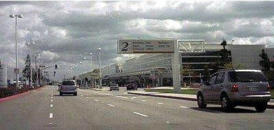
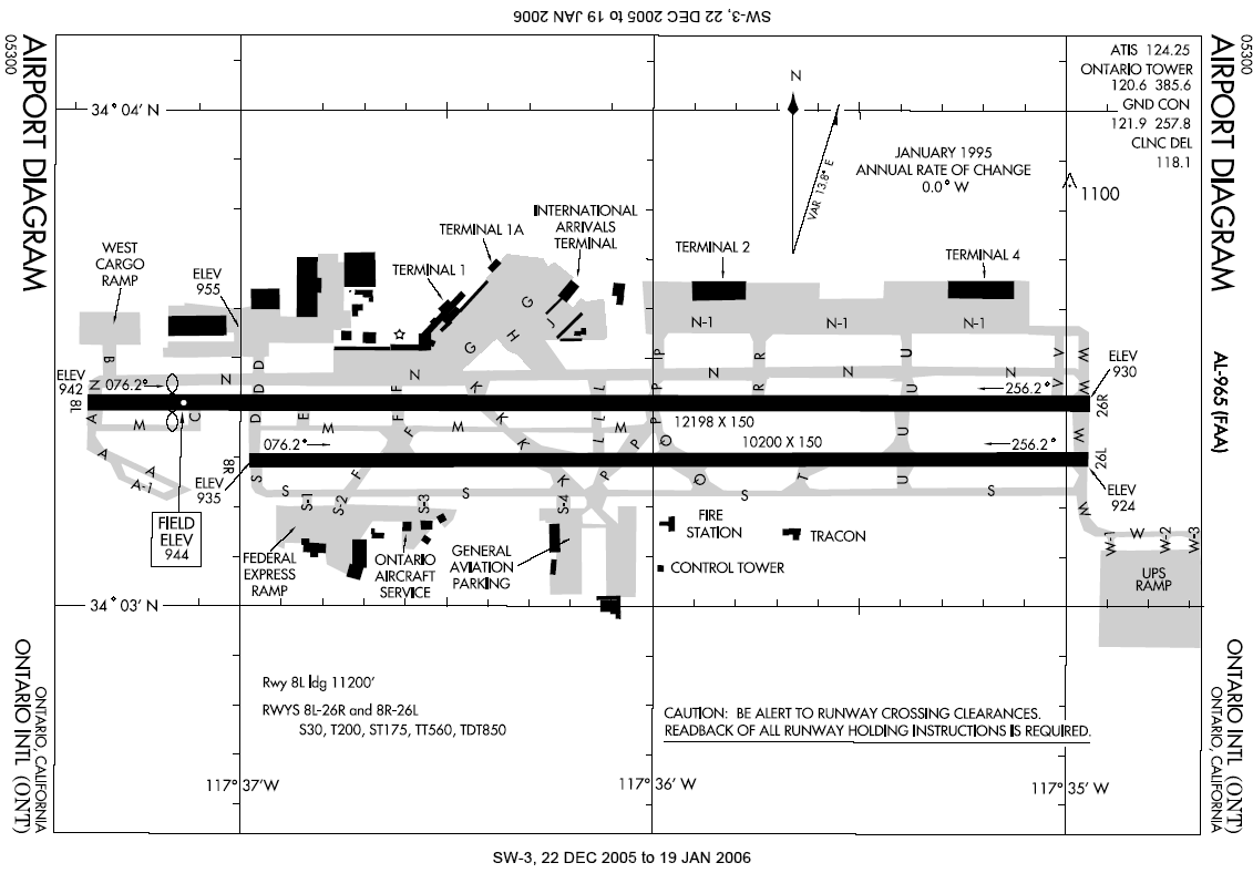
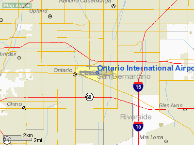
The airport covers 1,700 acres (690 ha) and has two runways. It is the third major airport in the area after Los Angeles International Airport (LAX) and John Wayne Airport (SNA). LA/Ontario International Airport is typically less crowded than LAX; according to Forbes.com it is one of the five best alternate airports in America. It is the West Coast air and truck hub for UPS and is a major distribution point for FedEx Express. LA/Ontario International Airport was a hub for the independent operations of ExpressJet Airlines, which began service to 14 destinations in April 2007. This service ended on September 2, 2008. Thanks to Ontario's long runways (runway 8L/26R is longer than any of those at LAX), it is often used as an alternate landing site for large aircraft when LAX is inaccessible due to weather conditions or other reasons. It is a particularly important alternate airport since there are many trans-Pacific flights headed to LAX which may not have enough fuel left after the long journey to reach other major airports. However, due to Ontario's relatively small customs facilities and limited options for connecting flights, such rerouted flights typically do not disembark passengers in Ontario. Instead, the airport is usually used to refuel the aircraft, which then take off again for a short flight to LAX once landing conditions there have improved. The airport is located approximately 38 miles (61 km) east of downtown Los Angeles, 18 miles (29 km) west of downtown San Bernardino and 14 miles (23 km) northwest of downtown Riverside. Motorists can either use the San Bernardino Freeway (Interstate 10), Ontario Freeway (Interstate 15), or the Pomona Freeway (State Route 60) to access the airport. It is also served by Omnitrans bus route 61, and by private shuttles, though most passengers drive or are picked up at the airport. By the end of 2006 Ontario International Airport was renamed to LA/Ontario International Airport in order to entice travelers from the already over-trafficked Los Angeles International Airport and also to reduce confusion with Ontario, Canada. LA/Ontario Airport is owned by the city of Los Angeles (LA World Airports) ONT currently has more then 70 daily departures and arrivals Noise restrictionsLA/Ontario has few noise restrictions/abatement rules unlike other Southern California airports such as John Wayne Airport, Bob Hope Airport, and Long Beach Airport which all have very strict policies. The airport is allowed to operate 24/7 but during the hours of 10pm through 7am all aircraft must arrive from the east on runway 26L and take-off to the east on runway 8L unless the weather has heavy winds blowing in the opposite direction or there is construction occurring that results in one runway not being able to be used. All aircraft must also depart from the very ends of the runway allowing aircraft to fly higher over neighborhoods. TerminalsLA/Ontario International Airport has three terminals. The terminal numbering scheme is designed to accommodate future growth. The airport's master plan calls for five terminals to be spaced adjacent to and in between the existing Terminals 2 and 4. The "international terminal" (which is a small building designed primarily to segregate arriving international passengers to clear customs) would be razed and be part of the new Terminal 1. One terminal would be dedicated exclusively to Southwest Airlines and the other to United Airlines, while the other airlines would share the remaining terminals. Terminal 2 has 265,000 square feet (24,600 m) and 12 gates (201 - 212). Terminal 4 has 265,000 square feet (24,600 m) and 14 gates (401 - 414). The International terminal has 2 gates. The old Ontario Airport had two terminals: the main terminal and a small terminal for Delta Air Lines and SkyWest Airlines. The old terminals are west of the current terminals and are visible when landing. The old flight control tower is still used as an auxiliary tower. The previous design was of the traditional walk-up type with only one jetway gate; the new terminals use the more modern jetway system. The old terminals currently house the administration and the USO, and are currently used to shoot airport scenes in movies and on television. They were used as an interior stand-in for the Los Angeles airport on the LAX TV series, and used for a key plot development on the fifth season of the series 24. The interior and exterior of Terminal 1 and the adjacent parking lot were used to portray a 1960s version of Miami International Airport in Catch Me If You Can. Other film productions utilizing the original airport buildings and locations include The Best Years of Our Lives (1946), Back Street (1961), The Counterfeit Killer (1968), Blow (2001), and Zodiac (2007). The old terminals will be torn down when the new Terminal 1 is constructed. Remote parking is located on the east end of the airport (moved from its previous location at the west end near the old terminals). Also on the east end, a ground transportation center is provided that consolidates all the rental car companies serving the airport in one central location. A circulator bus circles the airport and provides connections to each of the other terminals, rental car and remote parking lots, and the public transit stops. General aviation is located at the south side of the airport, although most general aviation pilots tend to use a number of nearby airports: Redlands Airport, Chino Airport, Cable Airport in Upland, or Rialto Municipal Airport. Airlines and destinations
Cargo OperationsThe airport caters to four cargo airlines, UPS Airlines, FedEx Express, Ameriflight, and ABX Air. Ontario is a major southwestern gateway hub for UPS.LA/ONT is the United Parcel Service's (UPS) Western Region hub for both air and trucking operations within a 13-state region. In addition to serving intra-regional traffic, the hub links to UPS's global hub in Louisville and serves as in international gateway for UPS' cargo flights to and from China. Popular culture
the airport as been used for numerous commericials The above content comes from Wikipedia and is published under free licenses – click here to read more.
Runway InformationRunway 08L/26R
Runway 08R/26L
Radio Navigation Aids
Remarks
Based Aircraft
Major Carriers Serving This Airport
Most Popular Destinations
Most Popular Aircraft
Operational Statistics
Ontario International Airport Address: San Bernardino County, CA Tel: 310-646-6250, 909-975-5300 Images
and information placed above are from We thank them for the data!
We don't guarantee the information is fresh and accurate. The data may
be wrong or outdated. |
|||||||||||||||||||||||||||||||||||||||||||||||||||||||||||||||||||||||||||||||||||||||||||||||||||||||||||||||||||||||||||||||||||||||||||||||||||||||||||||||||||||||||||||||||||||||||||||||||||||||||||||||||||||||||||||||||||||||||||||||||||||||||||||||||||||||||||||||||||||||||||||||||||||||||||||||||||||||||||||||||||||||||||||||||||||||||||||||||||||||||||||||||||||||||||||||||||||||||||||||||||||||||||||||||||||||||||||||||||||||||||||||||||||||||||||||||||||||||||||||||||||||||||||||||||||||||||||||||||||||||||||||||||||||||||||||||||||||||||||||||||||||||||||||||||||||||||||||||||

 |
|
Copyright 2004-2024 © by Airports-Worldwide.com, Vyshenskoho st. 36, Lviv 79010, Ukraine Legal Disclaimer |