 |
|
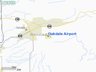
| Oakdale Airport |
| IATA: none – ICAO: none – FAA LID: O27 |
| Summary |
| Airport type |
Public |
| Operator |
City of Oakdale |
| Location |
Oakdale, California |
| Elevation AMSL |
234 ft / 71.3 m |
| Coordinates |
37°45′23″N 120°48′01″W / 37.75639°N 120.80028°W / 37.75639; -120.80028Coordinates: 37°45′23″N 120°48′01″W / 37.75639°N 120.80028°W / 37.75639; -120.80028 |
| Runways |
| Direction |
Length |
Surface |
| ft |
m |
| 10/28 |
3,020 |
920 |
Asphalt |
Oakdale Airport (FAA LID: O27) is a public airport located three miles (5 km) southeast of the central business district (CBD) of Oakdale, a city in Stanislaus County, California, USA. The airport covers 117 acres (47 ha) and has one runway. It is mostly used for general aviation.
The above content comes from Wikipedia and is published under free licenses – click here to read more.
Location
& QuickFacts
|
FAA
Information Effective: |
2006-09-28 |
|
Airport
Identifier: |
O27 |
|
Longitude/Latitude: |
120-48-00.7520W/37-45-22.8410N
-120.800209/37.756345 (Estimated) |
|
Elevation: |
234 ft / 71.32 m (Surveyed) |
|
Land: |
117 acres |
|
From
nearest city: |
3 nautical miles SE of Oakdale, CA |
|
Location: |
Stanislaus County, CA |
|
Magnetic Variation: |
15E (2000) |
Owner
& Manager
|
Ownership: |
Publicly owned |
|
Owner: |
City Of Oakdale |
|
Address: |
280 North 3rd Ave
Oakdale, CA 95361 |
|
Phone
number: |
209-847-3031 |
|
Manager: |
Steve Kyte
PUBLIC WORKS MAINTENANCE CONTACT: MARK KING (209)847-4245;
CELL (209) 505-5473 |
|
Address: |
8195 Laughlin Road
Oakdale, CA 95361 |
|
Phone number: |
209-845-3572 |
Airport
Operations and Facilities
|
Airport
Use: |
Open to public |
|
Wind
indicator: |
Yes |
|
Segmented
Circle: |
Yes |
|
Control
Tower: |
No |
|
Attendance
Schedule: |
ALL/ALL/DALGT
NIGHTS ON CALL. |
|
Lighting
Schedule: |
DUSK-DAWN
ACTVT MIRL RY 10/28 - CTAF. |
|
Beacon
Color: |
Clear-Green (lighted land airport) |
|
Landing
fee charge: |
No |
|
Sectional
chart: |
San Francisco |
|
Region: |
AWP - Western-Pacific |
|
Traffic
Pattern Alt: |
1000 ft |
|
Boundary
ARTCC: |
ZOA - Oakland |
|
Tie-in
FSS: |
RIU - Rancho Murieta |
|
FSS
on Airport: |
No |
|
FSS
Phone: |
916-354-0161 |
|
FSS
Toll Free: |
1-800-WX-BRIEF |
|
NOTAMs
Facility: |
RIU (NOTAM-d service avaliable) |
|
Federal Agreements: |
NGY |
Airport
Communications
|
CTAF: |
122.800 |
|
Unicom: |
122.800 |
Airport
Services
|
Fuel
available: |
100LL |
|
Airframe
Repair: |
MAJOR |
|
Power
Plant Repair: |
MAJOR |
|
Bottled
Oxygen: |
HIGH |
|
Bulk
Oxygen: |
HIGH |
|
Runway Information
Runway 10/28
|
Dimension: |
3020 x 66 ft / 920.5 x 20.1 m |
|
Surface: |
ASPH, Good Condition |
|
Weight
Limit: |
Single wheel: 20000 lbs. |
|
Edge
Lights: |
Medium |
|
|
Runway 10 |
Runway 28 |
|
Longitude: |
120-48-18.1870W |
120-47-43.2410W |
|
Latitude: |
37-45-28.3140N |
37-45-17.4270N |
|
Elevation: |
221.00 ft |
234.00 ft |
|
Alignment: |
111 |
127 |
|
Traffic
Pattern: |
Left |
Left |
|
Markings: |
Non-precision instrument, Good Condition |
Non-precision instrument, Good Condition |
|
Crossing
Height: |
22.00
ft |
0.00
ft |
|
VASI: |
2-box on left side |
|
|
Visual
Glide Angle: |
2.50� |
0.00� |
|
Runway
End Identifier: |
No |
No |
|
Centerline
Lights: |
No |
No |
|
Touchdown
Lights: |
No |
No |
|
Radio Navigation
Aids
|
ID |
Type |
Name |
Ch |
Freq |
Var |
Dist |
|
TCY |
NDB |
Tracy |
|
203.00 |
15E |
30.9 nm |
|
LV |
NDB |
Reiga |
|
374.00 |
16E |
42.2 nm |
|
MOD |
VOR/DME |
Modesto |
093X |
114.60 |
17E |
10.8 nm |
|
HYP |
VOR/DME |
El Nido |
089X |
114.20 |
15E |
37.5 nm |
|
ECA |
VORTAC |
Manteca |
107X |
116.00 |
17E |
18.2 nm |
|
LIN |
VORTAC |
Linden |
095X |
114.80 |
17E |
21.4 nm |
Remarks
- APRON
ON SOUTH SIDE OF RY DAMAGED & UNUSABLE.
- PREDATES
THE FAA ACT.
Based Aircraft
|
Aircraft
based on field: |
96 |
|
Single
Engine Airplanes: |
86 |
|
Multi
Engine Airplanes: |
10 |
Operational Statistics
|
Aircraft
Operations: |
49/Day |
|
Air Taxi: |
4.1% |
|
General
Aviation Local: |
51.0% |
|
General
Aviation Itinerant: |
44.9% |
Oakdale Airport
Address:
Stanislaus County, CA
Tel:
209-847-3031,
209-845-3572
Images
and information placed above are from
http://www.airport-data.com/airport/O27/
We
thank them for the data!
| General
Info |
| Country |
United
States |
| State |
CALIFORNIA
|
| FAA ID |
O27
|
| Latitude |
37-45-22.841N
|
| Longitude |
120-48-00.752W
|
| Elevation |
234 feet
|
| Near City |
OAKDALE
|
We don't guarantee the information is fresh and accurate. The data may
be wrong or outdated.
For more up-to-date information please refer to other sources.
|
|


