 |
|
| Nut Tree Airport |
| IATA: none – ICAO: KVCB – FAA LID: VCB |
| Summary |
| Airport type |
Public |
| Owner/Operator |
County of Solano |
| Serves |
Vacaville, California |
| Elevation AMSL |
117 ft / 36 m |
| Coordinates |
38°22′40″N 121°57′42″W / 38.37778°N 121.96167°W / 38.37778; -121.96167 |
| Website |
www.co.solano.ca.us/... |
| Runways |
| Direction |
Length |
Surface |
| ft |
m |
| 2/20 |
4,700 |
1,433 |
Asphalt |
| Statistics (1995) |
| Aircraft operations |
101,500 |
| Based aircraft |
180 |
| Source: Federal Aviation Administration |
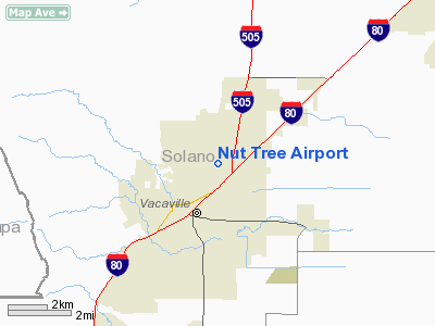
Nut Tree Airport (ICAO: KVCB, FAA LID: VCB) is a county-owned public-use airport located two nautical miles (3.7 km) northeast of the central business district of Vacaville, in Solano County, California, United States.
The airport is near the junction of Interstates 80 and 505. It is adjacent to the Nut Tree retail/commercial development, which replaced an historic US 40 highway stop from which both derive their name.
Facilities and aircraft
Nut Tree Airport covers an area of 262 acres (106 ha) at an elevation of 117 feet (36 m) above mean sea level. It has one runway designated 2/20 with an asphalt surface measuring 4,700 by 75 feet (1,433 x 23 m).
For the 12-month period ending March 3, 1995, the airport had 101,500 aircraft operations, an average of 278 per day: 98.5% general aviation and 1.5% air taxi. At that time there were 180 aircraft based at this airport: 90% single-engine, 8% multi-engine and 2% jet.
The above content comes from Wikipedia and is published under free licenses – click here to read more.
Location
& QuickFacts
|
FAA
Information Effective: |
2006-09-28 |
|
Airport
Identifier: |
VCB |
|
Longitude/Latitude: |
121-57-41.7000W/38-22-40.0000N
-121.961583/38.377778 (Estimated) |
|
Elevation: |
117 ft / 35.66 m (Surveyed) |
|
Land: |
262 acres |
|
From
nearest city: |
2 nautical miles NE of Vacaville, CA |
|
Location: |
Solano County, CA |
|
Magnetic Variation: |
15E (2005) |
Owner
& Manager
|
Ownership: |
Publicly owned |
|
Owner: |
Court House |
|
Address: |
580 Texas St
Fairfield, CA 94533 |
|
Phone
number: |
707-421-6100 |
|
Manager: |
John Swizer |
|
Address: |
301 County Airport Road
Vacaville, CA 95688 |
|
Phone number: |
707-446-0322 |
Airport
Operations and Facilities
|
Airport
Use: |
Open to public |
|
Wind
indicator: |
Yes |
|
Segmented
Circle: |
Yes |
|
Control
Tower: |
No |
|
Attendance
Schedule: |
MAY-OCT/ALL/0730-1930,NOV-APR/ALL/0800-1700 |
|
Lighting
Schedule: |
DUSK-DAWN
AFT 2200 ACTVT MIRL & PARALLEL TWY LGTS RY 02/20; PAPI
& REIL RYS 02 & 20 - CTAF. |
|
Beacon
Color: |
Clear-Green (lighted land airport) |
|
Landing
fee charge: |
No |
|
Sectional
chart: |
San Francisco |
|
Region: |
AWP - Western-Pacific |
|
Traffic
Pattern Alt: |
1000 ft |
|
Boundary
ARTCC: |
ZOA - Oakland |
|
Tie-in
FSS: |
RIU - Rancho Murieta |
|
FSS
on Airport: |
No |
|
FSS
Phone: |
916-354-0161 |
|
FSS
Toll Free: |
1-800-WX-BRIEF |
|
NOTAMs
Facility: |
VCB (NOTAM-d service avaliable) |
|
Federal Agreements: |
NGY |
Airport
Communications
|
CTAF: |
122.700 |
|
Unicom: |
122.700 |
Airport
Services
|
Fuel
available: |
100LLA |
|
Airframe
Repair: |
MAJOR |
|
Power
Plant Repair: |
MAJOR |
|
Bottled
Oxygen: |
NONE |
|
Bulk
Oxygen: |
NONE |
|
Runway Information
Runway 02/20
|
Dimension: |
4700 x 75 ft / 1432.6 x 22.9 m |
|
Surface: |
ASPH, Good Condition |
|
Weight
Limit: |
Single wheel: 30000 lbs. |
|
Edge
Lights: |
Medium |
|
|
Runway 02 |
Runway 20 |
|
Longitude: |
121-57-58.0161W |
121-57-25.3345W |
|
Latitude: |
38-22-20.6814N |
38-22-59.3174N |
|
Elevation: |
116.00 ft |
113.00 ft |
|
Alignment: |
34 |
127 |
|
Traffic
Pattern: |
Left |
Right |
|
Markings: |
Basic, Good Condition |
Basic, Good Condition |
|
VASI: |
2-light PAPI on left side |
2-light PAPI on left side |
|
Runway
End Identifier: |
Yes |
Yes |
|
Centerline
Lights: |
No |
No |
|
Touchdown
Lights: |
No |
No |
|
Obstruction: |
42 ft poles, 1250.0 ft from runway, 200 ft
left of centerline, 25:1 slope to clear |
, 50:1 slope to clear |
|
Radio Navigation
Aids
|
ID |
Type |
Name |
Ch |
Freq |
Var |
Dist |
|
LV |
NDB |
Reiga |
|
374.00 |
16E |
43.3 nm |
|
TCY |
NDB |
Tracy |
|
203.00 |
15E |
47.9 nm |
|
SUU |
TACAN |
Travis |
113X |
|
17E |
8.0 nm |
|
TZZ |
VOR |
Travis |
|
116.40 |
17E |
7.4 nm |
|
CCR |
VOR/DME |
Concord |
117X |
117.00 |
17E |
20.4 nm |
|
MCC |
VOR/DME |
Mc Clellan |
029X |
109.20 |
17E |
31.5 nm |
|
STS |
VOR/DME |
Santa Rosa |
077X |
113.00 |
16E |
40.7 nm |
|
MYV |
VOR/DME |
Marysville |
045X |
110.80 |
16E |
47.0 nm |
|
SFO |
VOR/DME |
San Francisco |
105X |
115.80 |
17E |
49.6 nm |
|
SAC |
VORTAC |
Sacramento |
099X |
115.20 |
17E |
19.7 nm |
|
SGD |
VORTAC |
Scaggs Island |
058X |
112.10 |
17E |
22.8 nm |
|
OAK |
VORTAC |
Oakland |
115X |
116.80 |
17E |
41.1 nm |
|
SAU |
VORTAC |
Sausalito |
109X |
116.20 |
17E |
41.1 nm |
|
ILA |
VORTAC |
Williams |
091X |
114.40 |
18E |
41.8 nm |
|
PYE |
VORTAC |
Point Reyes |
084X |
113.70 |
17E |
46.4 nm |
|
LIN |
VORTAC |
Linden |
095X |
114.80 |
17E |
48.8 nm |
|
ECA |
VORTAC |
Manteca |
107X |
116.00 |
17E |
49.7 nm |
|
SAC |
VOT |
Sacramento Executive |
|
111.40 |
|
23.3 nm |
|
SMF |
VOT |
Sacramento Metropolitan |
|
111.40 |
|
25.6 nm |
|
SFO |
VOT |
San Francisco Intl |
|
111.00 |
|
49.6 nm |
Remarks
- NO
TURNS TO CROSSWIND BLO 800 FT MSL; NOISE SENSITIVE AREA WEST OF AIRPORT.
Based Aircraft
|
Aircraft
based on field: |
247 |
|
Single
Engine Airplanes: |
204
INCLUDES 4 GYROPLANES. |
|
Multi
Engine Airplanes: |
40 |
|
Jet Engine
Airplanes: |
1 |
|
Helicopters: |
2 |
Operational Statistics
|
Aircraft
Operations: |
279/Day |
|
Air Taxi: |
1.5% |
|
General
Aviation Local: |
39.4% |
|
General
Aviation Itinerant: |
59.1% |
Nut Tree Airport
Address:
Solano County, CA
Tel:
707-421-6100,
707-446-0322
Images
and information placed above are from
http://www.airport-data.com/airport/VCB/
We
thank them for the data!
| General
Info |
| Country |
United
States |
| State |
CALIFORNIA
|
| FAA ID |
VCB
|
| Latitude |
38-22-36.306N
|
| Longitude |
121-57-44.838W
|
| Elevation |
114 feet
|
| Near City |
VACAVILLE
|
We don't guarantee the information is fresh and accurate. The data may
be wrong or outdated.
For more up-to-date information please refer to other sources.
|
|


