|
 |
|
||||
|
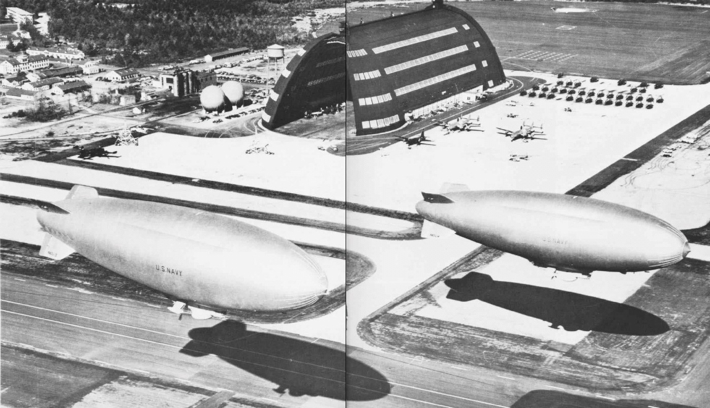
Naval Air Station South Weymouth, or SOWEY as it is sometimes known, was an operational United States Navy airfield from 1942 to 1997. It was first established as a regular Navy blimp base during World War II. During the postwar era the base became an important component of the Naval Air Reserve Training Command, hosting a diverse and changing variety of Navy and Marine Corps reserve aircraft squadrons and other types of reserve units throughout the years. It is located in South Weymouth, Rockland, and Abington, Massachusetts. World War IIIn 1938, the site was surveyed as a possible location for a municipal airport, which was never built. Construction work on the base began in September 1941 and the base was commissioned as the United States Naval Air Station South Weymouth on March 1, 1942. During WWII the base's primary mission was to provide support for anti-submarine blimp operations. In its original as-built format South Weymouth's main facilities consisted of two gigantic blimp hangars, the earlier (LTA Hangar One or "The Big Hangar") of steel construction and the second (LTA Hangar Two) of the more common World War II wood frame construction. The base also had a 2,000-foot-diameter (610 m) Macadamized blimp landing mat, six mooring circles, and a 4,500-foot-long (1,400 m) turf runway. Throughout the war with Germany NAS South Weymouth served as the home base of airship patrol squadron ZP-11, which operated up to twelve K class blimps employed on ASW patrols and convoy escort missions in and around Massachusetts Bay and the Gulf of Maine. Some historians and former Navy personnel allege that a ZP-11 blimp, the K-14, which crashed with loss of life off the coast of Bar Harbor, Maine on July 2, 1944 was actually shot down by a German submarine. In addition to ZP-11, NAS South Weymouth also hosted wartime detachments of airship patrol squadron ZP-12 based at NAS Lakehurst, New Jersey and airship utility squadron ZJ-1 based at Meacham Field in Key West, Florida. ZJ-1 was unique, being the only airship utility squadron in the Navy. ZJ-1's South Weymouth detachment flew K and G class airships in support of electronics research projects conducted by the Massachusetts Institute of Technology, performed aerial photography missions, and helped to recover test torpedoes for the Navy torpedo station in Newport, Rhode Island. In 1944, NAS South Weymouth was the starting point for the first transatlantic crossings of non-rigid airships. United States Navy K-ships (blimps) K-123 and K-130 from Blimp Squadron 14 (also known as ZP-14, Blimpron 14, or "The Africa Squadron") left South Weymouth on May 28, 1944 and landed at Argentia, Newfoundland about 16 hours later. The two K-ships then flew approximately 22 hours to Lagens Field on Terceira Island in the Azores. The last leg of the flight was a ~20 hour flight to their destination with Fleet Air Wing (FAW) 15 at Port Lyautey, French Morocco (now Kenitra, Morocco). Blimps K-123 & K-130 were followed by K-109 & K-134 and K-112 & K-101 which left South Weymouth on June 11 and 27, respectively, in 1944. These six blimps initially conducted nighttime anti-submarine warfare operations to complement the daytime missions flown by FAW-15 aircraft (PBYs and B-24s) using magnetic anomaly detection to locate U-boats in the relatively shallow waters around the Straits of Gibraltar. Later, ZP-14 K-ships conducted minespotting and minesweeping operations in key Mediterranean ports and various escort missions including that of the convoy carrying Franklin Roosevelt and Winston Churchill to the Yalta Conference in early 1945. Post-war demobilization and Cold War useSouth Weymouth was downgraded from a naval air station to a naval air facility after Germany surrendered, thus ending the U-Boat threat to the east coast, and was thereafter used to store surplus naval aircraft that were awaiting final disposition. Many of these aircraft, especially Eastern/Grumman TBM/TBF Avengers, were subjected to elaborate cocooning and preservation methods in the two huge blimp hangars. During this period of South Weymouth's history the base was known as a naval aircraft parking station or "NAPS". Naval Air Facility South Weymouth was placed into caretaker status in 1949 and downgraded again to a naval auxiliary aviation facility or NAAF. In 1950 the Navy decided to close Squantum Naval Air Station, traditionally the focus of Navy and Marine Corps reserve aviation training in New England, and move the reserve program to NAAF South Weymouth. The decision to close NAS Squantum resulted from increasing incidents of airspace conflicts with Boston's commercial airport (modern-day Logan International Airport) in nearby East Boston and due to the fact that Squantum's relatively short and landlocked (waterlocked?) runways were not capable of supporting high-performance jet aircraft. Between 1952 and 1953 NAAF South Weymouth was rebuilt to make it more suitable for supporting conventional aircraft operations. In its original WWII format, the base was not really intended for regular use by heavier-than-air aircraft. Its turf runways were only intended for transient aircraft and the station's light Beech GB Traveler. During the 1952–1953 reconstruction effort LTA Hangar Two (the wooden blimp hangar) was torn down, three new paved runways (7,000-foot (2,100 m) north–south runway 17/35, 2,000-foot (610 m) east–west runway 08/26, and 5,000-foot (1,500 m) diagonally aligned runway 02/20) were built, and a CPN-4 ground-controlled-approach facility and modern control tower (the wartime base's control towers were located on top of LTA Hangar One) were established. South Weymouth was reactivated as a reserve training base and fully-fledged naval air station on December 4, 1953. Though officially a reserve base, NAS South Weymouth hosted an unusual regular Navy unit between 1953 and 1961. This was a secretive research and development outfit called the Naval Air Development Unit, known as "NADU" for short. The NADU, which derived in a way from Special Project Unit (SPU) CAST based at Squantum Naval Air Station during WWII, was tasked with providing flight testing support for research projects associated with the MIT Lincoln Laboratories and other defense contractors. Mainly, these research projects involved experimental electronic equipment such as radars associated with air defense and anti-submarine warfare systems. The NADU operated a very diverse aircraft fleet over the years that included among other things Lockheed WV-2 Warning Stars, Douglas F4D Skyrays, Douglas F3D Skyknights, Lockheed P2V Neptunes, and the ZPG-2W, which were the world's largest blimps.
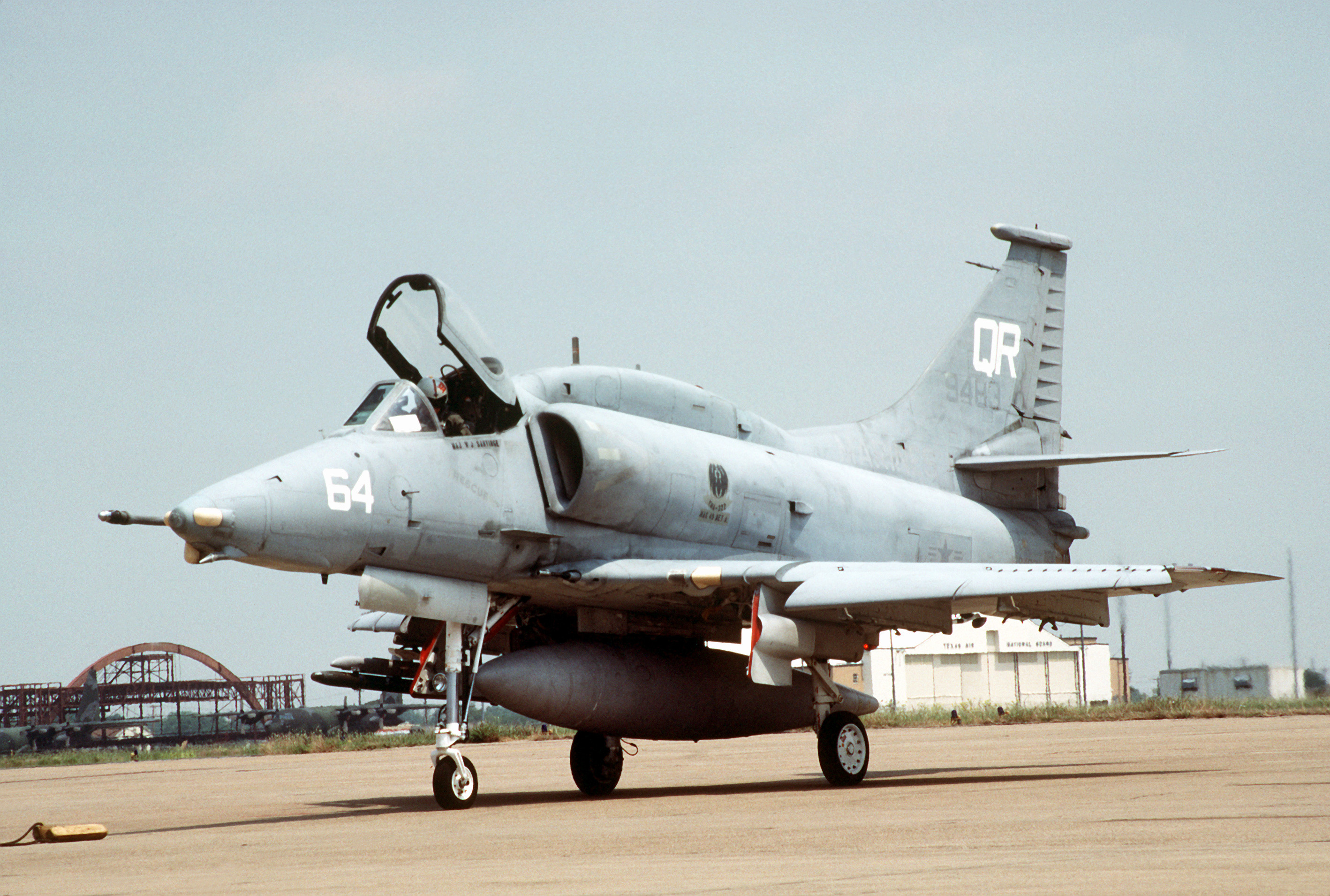
In 1957 a new hangar, Hangar #2, was built adjacent to runway 17/35 to support the fixed-wing ASW and attack squadrons. Runway 08/26 was lengthened to 6,000 feet during 1959. The construction work required on the eastern end of this runway permanently severed Union Street, which had served as a major thoroughfare connecting the towns of Rockland and Weymouth. Blimp operations were discontinued at NAS South Weymouth in October 1961 when the Naval Air Development Unit was disestablished. During the 1960s the station hosted a pair of unique Anti-Submarine Warfare Operational Flight Trainers. These consisted of two retired aircraft fuselages, a Grumman S-2 Tracker (crash damaged) and a Lockheed SP-2E Neptune (fire damaged), that were placed on the flat roof of the so-called "lean-to" on the southern side of LTA Hangar One. The radar scopes and other ASW sensors positioned at the tactical crew positions in these two aircraft fuselages were connected to signal generating devices located in the ASW Training Department spaces in the hangar, allowing them to serve as fixed tactical training simulators for reserve aircrewmen. Steel blimp hangar LTA Hangar One, a local landmark, was torn down during late 1966 and replaced with a much smaller concrete arch hangar (Hangar #1). The base had target ranges at the nearby Nomans Land Island and the Liberty Ship SS James Longstreet. The base hosted the Navy Weymouth Aero Club from around 1977 until the club's closure in 1984. Base Realignment and Closure CommissionBRAC 1991The Base Realignment and Closure Commission decided to close the base in its recommendations. It was decided against because of the community's objections. BRAC 1993The Base Realignment and Closure Commission decided to close the base in its recommendations. The community argued that it was important and was ranked higher than other bases scheduled for realignment. This argument was acknowledged as well as the fact that the commission did not include demographics in its decision. The base remained open for the time being. BRAC 1995The Base Realignment and Closure Commission of 1995 recommended that South Weymouth close in 1997 and its last remaining squadrons be realigned. VP-92, which flew P-3 Orions and VR-62, which flew C-130 Hercules transports, went to Brunswick NAS before the base was officially deactivated and closed by order of the 1995 BRAC. RedevelopmentFile:Retail USES-big.gif There are currently plans to put movie studios, shops, housing, a wildlife park, and a golf course at the site of the former air station. The U.S. Coast Guard also maintains a buoy maintenance facility near the old railroad spur to the station. An A-4 Skyhawk jet mounted on a pedestal in a small park called the "Shea Memorial Grove", named for Squantum reservist CDR John "Jack" Shea who was killed in action when the aircraft carrier USS Wasp was sunk during WWII, remains as a perpetual reminder of the site's naval heritage. The jet, the park, and a small Navy museum located in the former base gymnasium building are maintained by a local veteran's organization called the Association of Naval Aviation Patriot Squadron [1]. In December 2008, a deal was reached to build a movie studio complex on the site. The $100 million complex, to be called SouthField Studios, is planned to include 11 sound stages, production offices and other office space. Construction was set to begin in August 2009, but has been stalled due to financing difficulties. The base also features a planned condominium community development called 'SouthField' [2]. Units Hosted
GalleryThe above content comes from Wikipedia and is published under free licenses – click here to read more.
Runway InformationRunway 11/29
Runway 18/36
Radio Navigation Aids
Remarks
North Island Nas /halsey Field/ Airport Address: San Diego County, CA Tel: Images
and information placed above are from We thank them for the data!
We don't guarantee the information is fresh and accurate. The data may
be wrong or outdated. |
||||||||||||||||||||||||||||||||||||||||||||||||||||||||||||||||||||||||||||||||||||||||||||||||||||||||||||||||||||||||||||||||||||||||||||||||||||||||||||||||||||||||||||||||||||||||||||||||||||||||||||||||||||||||||||||||||||||||||||||||||||||||||||||||||||||||||||||||||||||||||||||||||||||||||||||||||||||||||||||||||||||||||||||||||||||||||||||||

 |
|
Copyright 2004-2024 © by Airports-Worldwide.com, Vyshenskoho st. 36, Lviv 79010, Ukraine Legal Disclaimer |