 |
|
New Coalinga Municipal Airport |
| New Coalinga Municipal Airport |
| IATA: CLG – ICAO: none – FAA LID: C80 |
| Summary |
| Airport type |
Public |
| Owner |
City of Coalinga |
| Location |
Coalinga, California |
| Elevation AMSL |
622 ft / 190 m |
| Coordinates |
36°09′47″N 120°17′38″W / 36.16306°N 120.29389°W / 36.16306; -120.29389 |
| Runways |
| Direction |
Length |
Surface |
| ft |
m |
| 1/19 |
2,500 |
762 |
Asphalt/Gravel |
| 12/30 |
5,000 |
1,524 |
Asphalt |
| Helipads |
| Number |
Length |
Surface |
| ft |
m |
| H1 |
50 |
15 |
Asphalt |
| Statistics (2003) |
| Aircraft operations |
2,400 |
| Source: Federal Aviation Administration |
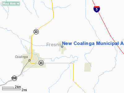
New Coalinga Municipal Airport (IATA: CLG, FAA LID: C80) is a public airport located three miles (5 km) east of the central business district of Coalinga, in Fresno County, California, United States. It is owned by the City of Coalinga.
Facilities and aircraft
New Coalinga Municipal Airport covers an area of 1,002 acres (405 ha) which contains two runways (1/19: 2,500 x 60 ft (18 m), 12/30: 5,000 x 100 ft) and one helipad (H1: 50 x 50 ft). For the 12-month period ending May 9, 2003, the airport had 2,400 aircraft operations, all of which were general aviation.
The above content comes from Wikipedia and is published under free licenses – click here to read more.
Location
& QuickFacts
|
FAA
Information Effective: |
2006-09-28 |
|
Airport
Identifier: |
C80 |
|
Longitude/Latitude: |
120-17-37.7300W/36-09-47.3000N
-120.293814/36.163139 (Estimated) |
|
Elevation: |
622 ft / 189.59 m (Estimated) |
|
Land: |
1002 acres |
|
From
nearest city: |
3 nautical miles E of Coalinga, CA |
|
Location: |
Fresno County, CA |
|
Magnetic Variation: |
15E (1995) |
Owner
& Manager
|
Ownership: |
Publicly owned |
|
Owner: |
City Of Coalinga |
|
Address: |
City Hall 155 W Durian
Coalinga, CA 93210 |
|
Phone
number: |
290-935-1534 |
|
Manager: |
Karen L. Mattice |
|
Address: |
The City Of Coalinga, 155 West Durian
Coalinga, CA 93210 |
|
Phone number: |
559-935-1533 |
Airport
Operations and Facilities
|
Airport
Use: |
Open to public |
|
Wind
indicator: |
Yes |
|
Segmented
Circle: |
Yes |
|
Control
Tower: |
No |
|
Attendance
Schedule: |
IREG |
|
Lighting
Schedule: |
DUSK-DAWN
MIRL RY 12/30; PERIMETER LGTS RY H1; PAPI RYS 12 & 30;
REIL RYS 12 & 30 ON DUSK-0000; AFTER 0000 ACTVT - CTAF. |
|
Beacon
Color: |
Clear-Green (lighted land airport) |
|
Landing
fee charge: |
No |
|
Sectional
chart: |
San Francisco |
|
Region: |
AWP - Western-Pacific |
|
Traffic
Pattern Alt: |
1000 ft |
|
Boundary
ARTCC: |
ZOA - Oakland |
|
Tie-in
FSS: |
RIU - Rancho Murieta |
|
FSS
on Airport: |
No |
|
FSS
Phone: |
916-354-0161 |
|
FSS
Toll Free: |
1-800-WX-BRIEF |
|
NOTAMs
Facility: |
RIU (NOTAM-d service avaliable) |
|
Federal Agreements: |
NGY |
Airport
Communications
|
CTAF: |
122.700 |
|
Unicom: |
122.700 |
Airport
Services
|
Runway Information
Runway 01/19
|
Dimension: |
2500 x 60 ft / 762.0 x 18.3 m |
|
Surface: |
ASPH-GRVL, Poor Condition
RY 01/19 IS IN POOR CONDITION; ASPHALT-GRVL CRACKED IN PLACES WITH
SMALL POTHOLES, ROCKS AND LOOSE GRAVEL.
OIL
TREATED. |
|
Weight
Limit: |
Single wheel: 12500 lbs.
RY 01/19 RESTRICTED BY AIRPORT MGT TO ACFT UNDER 6,000 LBS SINGLE
WHEEL. |
|
|
Runway 01 |
Runway 19 |
|
Traffic
Pattern: |
Left |
Right |
|
Markings: |
, |
Basic, Good Condition |
|
Runway 12/30
|
Dimension: |
5000 x 100 ft / 1524.0 x 30.5 m |
|
Surface: |
ASPH, Good Condition
RY 01/19 IS IN POOR CONDITION; ASPHALT-GRVL CRACKED IN PLACES WITH
SMALL POTHOLES, ROCKS AND LOOSE GRAVEL.
OIL
TREATED. |
|
Weight
Limit: |
Single wheel: 30000 lbs.
RY 01/19 RESTRICTED BY AIRPORT MGT TO ACFT UNDER 6,000 LBS SINGLE
WHEEL. |
|
Edge
Lights: |
Medium
PERIMETER LGTS. |
|
|
Runway 12 |
Runway 30 |
|
Traffic
Pattern: |
Left |
Right |
|
Markings: |
Basic, Good Condition |
Basic, Good Condition |
|
Crossing
Height: |
40.00 ft |
40.00 ft |
|
VASI: |
2-light PAPI on left side |
2-light PAPI on left side |
|
Visual
Glide Angle: |
3.00� |
3.00� |
|
Runway
End Identifier: |
Yes |
Yes |
|
Helipad H1
|
Dimension: |
50 x 50 ft / 15.2 x 15.2 m |
|
Surface: |
ASPH, Good Condition
RY 01/19 IS IN POOR CONDITION; ASPHALT-GRVL CRACKED IN PLACES WITH
SMALL POTHOLES, ROCKS AND LOOSE GRAVEL.
OIL
TREATED. |
|
|
Runway H1 |
Runway |
|
Traffic
Pattern: |
Left |
Left |
|
Markings: |
Basic, Good Condition |
, |
|
Radio Navigation
Aids
|
ID |
Type |
Name |
Ch |
Freq |
Var |
Dist |
|
COR |
NDB |
Salyer Farms |
|
205.00 |
16E |
37.2 nm |
|
FCH |
NDB |
Chandler |
|
344.00 |
15E |
40.4 nm |
|
HGT |
NDB |
Hunter Liggett |
|
209.00 |
15E |
45.2 nm |
|
CUK |
NDB |
Academy |
|
266.00 |
14E |
46.6 nm |
|
NLC |
TACAN |
Lemoore |
080X |
|
16E |
19.2 nm |
|
ROM |
VOR |
Priest |
|
110.00 |
16E |
18.1 nm |
|
VIS |
VOR/DME |
Visalia |
031X |
109.40 |
16E |
41.2 nm |
|
PRB |
VORTAC |
Paso Robles |
090X |
114.30 |
16E |
33.7 nm |
|
AVE |
VORTAC |
Avenal |
118X |
117.10 |
16E |
34.6 nm |
|
PXN |
VORTAC |
Panoche |
073X |
112.60 |
16E |
40.6 nm |
|
CZQ |
VORTAC |
Clovis |
076X |
112.90 |
15E |
49.1 nm |
Remarks
- RY
01/19 AVBL FOR DAYTIME USE ONLY.
Based Aircraft
|
Aircraft
based on field: |
10 |
|
Single
Engine Airplanes: |
10 |
Operational Statistics
|
Aircraft
Operations: |
47/Week |
|
General
Aviation Itinerant: |
100.0% |
New Coalinga Municipal Airport
Address:
Fresno County, CA
Tel:
290-935-1534,
559-935-1533
Images
and information placed above are from
http://www.airport-data.com/airport/C80/
We
thank them for the data!
| General
Info |
| Country |
United
States |
| State |
CALIFORNIA
|
| FAA ID |
C80
|
| Latitude |
36-09-47.300N
|
| Longitude |
120-17-37.730W
|
| Elevation |
622 feet
|
| Near City |
COALINGA
|
We don't guarantee the information is fresh and accurate. The data may
be wrong or outdated.
For more up-to-date information please refer to other sources.
|
|


