 |
|
| Mountain Valley Airport |
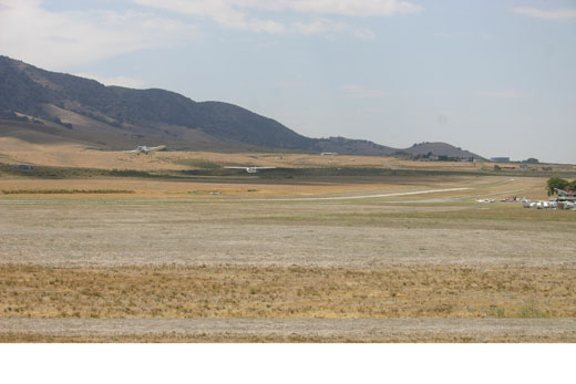 |
| tow plane and glider taking off at Mountain Valley Airport |
| IATA: none – ICAO: none – FAA LID: L94 |
| Summary |
| Airport type |
Public |
| Owner/Operator |
Larry G Barrett |
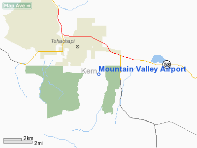
| Location |
Tehachapi, California |
| Elevation AMSL |
4220 ft / 1826 m |
| Coordinates |
35°06′03.8800″N 118°25′23.3010″W / 35.1010778°N 118.42313917°W / 35.1010778; -118.42313917Coordinates: 35°06′03.8800″N 118°25′23.3010″W / 35.1010778°N 118.42313917°W / 35.1010778; -118.42313917 |
| Website |
http://www.tehachapi.com/glider/home.htm |
| Runways |
| Direction |
Length |
Surface |
| ft |
m |
| 9L/27R |
4890 |
1490 |
asphalt/dirt |
| 9R/27L |
4890 |
1490 |
asphalt/dirt |
| runway 9L/27R for sailplane use only |
Mountain Valley Airport (FAA LID: L94) is an airport used for glider operations and training located in Tehachapi, California. The airport was established for its close proximity to various advantageous lift effects for soaring where the Sierra Nevada Mountains, Tehachapi Mountains and the Mojave Desert meet.
The Skylark North Glider School performs glider flight training for civilians as well as for the US Air Force Test Pilot School (from Edwards AFB), the National Test Pilot School (from the Mojave Air & Space Port), NASA and others. Due to the ongoing training contract with the US Air Force Test Pilot School, probably most or nearly all NASA Space Shuttle pilots who came from the Air Force have received glider training at Mountain Valley Airport.
There are a sandwich shop and an RV park & campground on field. The nearest fuel sales are at Tehachapi Municipal Airport 2 miles to the north.
The above content comes from Wikipedia and is published under free licenses – click here to read more.
Location
& QuickFacts
|
FAA
Information Effective: |
2006-09-28 |
|
Airport
Identifier: |
L94 |
|
Longitude/Latitude: |
118-25-23.3010W/35-06-03.8800N
-118.423139/35.101078 (Estimated) |
|
Elevation: |
4220 ft / 1286.26 m (Estimated) |
|
Land: |
170 acres |
|
From
nearest city: |
2 nautical miles SE of Tehachapi, CA |
|
Location: |
Kern County, CA |
|
Magnetic Variation: |
14E (1985) |
Owner
& Manager
|
Ownership: |
Privately owned |
|
Owner: |
Larry G Barrett |
|
Address: |
Po Box 100
Tehachapi, CA 93581 |
|
Phone
number: |
661-822-5267 |
|
Manager: |
Larry G Barrett
ALTERNATE CONTACT: MRS. JANE BARRETT |
|
Address: |
16334 Harris Road
Tehachapi, CA 93561 |
|
Phone number: |
661-822-5267 |
Airport
Operations and Facilities
|
Airport
Use: |
Open to public |
|
Wind
indicator: |
Yes |
|
Segmented
Circle: |
Yes |
|
Control
Tower: |
No |
|
Attendance
Schedule: |
ALL/ALL/DAWN-DUSK |
|
Landing
fee charge: |
No |
|
Sectional
chart: |
Los Angeles |
|
Region: |
AWP - Western-Pacific |
|
Traffic
Pattern Alt: |
1000 ft |
|
Boundary
ARTCC: |
ZLA - Los Angeles |
|
Tie-in
FSS: |
RIU - Rancho Murieta |
|
FSS
on Airport: |
No |
|
FSS
Phone: |
916-354-0161 |
|
FSS
Toll Free: |
1-800-WX-BRIEF |
|
NOTAMs
Facility: |
RIU (NOTAM-d service avaliable) |
Airport
Communications
|
CTAF: |
123.000 |
|
Unicom: |
123.000 |
Airport
Services
|
Airframe
Repair: |
MAJOR |
|
Power
Plant Repair: |
MAJOR |
|
Bottled
Oxygen: |
LOW |
|
Bulk
Oxygen: |
LOW |
|
Runway Information
Runway 09L/27R
|
Dimension: |
4890
x 36 ft / 1490.5 x 11.0 m
RY END 09L FIRST 1,200 FT X 36 FT DIRT; RY END 27R REMAINING 3,690
FT ASPHALT OF VARYING WIDTHS.
RY END 09R FIRST 1,200 FT X 36 FT DIRT; RY END 27L REMAINING 3,690
FT X 36 FT ASPHALT.
PARTIALLY
PAVED PORTIONS OF THE RUNWAY 20 FEET WIDE |
|
Surface: |
ASPH-DIRT, Fair Condition |
|
|
Runway 09L |
Runway 27R |
|
Traffic
Pattern: |
Left |
Right |
|
Markings: |
Nonstandard,
NON STANDARD THRESHOLD MARKING ONLY |
Nonstandard,
NON STANDARD THRESHOLD MARKING ONLY |
|
Runway
End Identifier: |
No |
No |
|
Centerline
Lights: |
No |
No |
|
Touchdown
Lights: |
No |
No |
|
Obstruction: |
37 ft road, 1240.0 ft from runway, 250 ft left
of centerline, 33:1 slope to clear |
18 ft berm, 510.0 ft from runway, 155 ft right
of centerline, 17:1 slope to clear |
|
Runway 09R/27L
|
Dimension: |
4890
x 36 ft / 1490.5 x 11.0 m
RY END 09L FIRST 1,200 FT X 36 FT DIRT; RY END 27R REMAINING 3,690
FT ASPHALT OF VARYING WIDTHS.
RY END 09R FIRST 1,200 FT X 36 FT DIRT; RY END 27L REMAINING 3,690
FT X 36 FT ASPHALT.
PARTIALLY
PAVED PORTIONS OF THE RUNWAY 20 FEET WIDE |
|
Surface: |
ASPH-DIRT, Fair Condition |
|
|
Runway 09R |
Runway 27L |
|
Traffic
Pattern: |
Right |
Left |
|
Markings: |
Nonstandard, Fair Condition |
Nonstandard, Good Condition |
|
Runway
End Identifier: |
No |
No |
|
Centerline
Lights: |
No |
No |
|
Touchdown
Lights: |
No |
No |
|
Obstruction: |
79 ft tree, 2140.0 ft from runway, 120 ft right
of centerline, 27:1 slope to clear |
18 ft berm, 560.0 ft from runway, 160 ft right
of centerline, 20:1 slope to clear |
|
Radio Navigation
Aids
|
ID |
Type |
Name |
Ch |
Freq |
Var |
Dist |
|
GWF |
NDB |
Gen William J Fox |
|
282.00 |
15E |
24.0 nm |
|
LHS |
VORTAC |
Lake Hughes |
021X |
108.40 |
15E |
26.3 nm |
|
GMN |
VORTAC |
Gorman |
108X |
116.10 |
16E |
28.0 nm |
|
PMD |
VORTAC |
Palmdale |
092X |
114.50 |
15E |
33.3 nm |
|
EDW |
VORTAC |
Edwards |
111X |
116.40 |
15E |
34.7 nm |
|
EHF |
VORTAC |
Shafter |
101X |
115.40 |
14E |
40.3 nm |
|
BFL |
VOT |
Bakersfield |
|
111.20 |
|
36.3 nm |
Remarks
-
< 9R
RWY USE S, FM APCH ACFT PWR 27R; 9L N,>
- RY
09R/27L MARKED WITH NSTD THLD BARS EACH END; NO NUMBERS NO CNTRLN.
Based Aircraft
|
Aircraft
based on field: |
90 |
|
Single
Engine Airplanes: |
10 |
|
Gliders: |
80 |
Operational Statistics
|
Aircraft
Operations: |
137/Day |
|
General
Aviation Local: |
86.0% |
|
General
Aviation Itinerant: |
11.6% |
|
Military: |
2.4% |
Mountain Valley Airport
Address:
Kern County, CA
Tel:
661-822-5267
Images
and information placed above are from
http://www.airport-data.com/airport/L94/
We
thank them for the data!
| General
Info |
| Country |
United
States |
| State |
CALIFORNIA
|
| FAA ID |
L94
|
| Latitude |
35-06-03.880N
|
| Longitude |
118-25-23.301W
|
| Elevation |
4220 feet
|
| Near City |
TEHACHAPI
|
We don't guarantee the information is fresh and accurate. The data may
be wrong or outdated.
For more up-to-date information please refer to other sources.
|
|


